Home > Blog > Weather
Anatomy of a Typhoon
Each generation has its share of mind-blowing disasters. For our generation, one of the worst devastations ever to hit our country was caused by Typhoon Yolanda. Today, we remember the wrath of this ferocious typhoon that greatly affected the Visayas area exactly three years ago.
Based on the climatological records of PAGASA, tropical cyclones that enter the Philippine Area of Responsibility (PAR) during the month of November have a higher chance of hitting the landmass. Proof of this wasYolanda, which originated from the Pacific Ocean, gaining much strength as it headed towards the Philippines.
With the international name Haiyan, Yolanda became one of the world’s most disastrous typhoons, packing winds of up to 235 kilometers per hour and with a gustiness reaching 270 kilometers per hour.
Within a day, six landfall activities were recorded by the Philippine Atmospheric Geophysical and Astronomical Services Administration (PAGASA). On November 8, 2013, Yolanda hit the following areas:
– Guiuan, Eastern Samar
– Tolosa, Leyte
– Daanbantayan, Cebu
– Bantayan Island, Cebu
– Concepcion, IloIlo
– Busuanga, Palawan
Yolanda exited the PAR on November 9, 2013, leaving a horrific view of Leyte and Samar. Aside from flash floods and landslides, the intense winds of the typhoon triggered storm surges that devoured Leyte, particularly the city of Tacloban. Many Taclobanons said it was like the entire sea had crawled over the land.
At least 6,000 people were reported dead while more than a thousand are still missing. Thousands of families were affected in Regions IV, V, VI, VII, VIII, X, XI and CARAGA. The combined power of water and winds smashed almost 1.2 million houses.
“Super Typhoon”
Days before the first anniversary of Yolanda in 2014, the Typhoon Committee of PAGASA decided to revise the classification of tropical cyclones, adding the category “Super Typhoon” to the list.
PAGASA explained that the revision aims to emphasize the intensity of a tropical cyclone and the threat of its impacts. Using the term “Super Typhoon” will also escalate the sense of urgency and community response in times of an approaching storm.
In October this year, “Lawin” became the first tropical cyclone to be classified as a super typhoon— the first time that PAGASA issued Signal Number 5 as well.
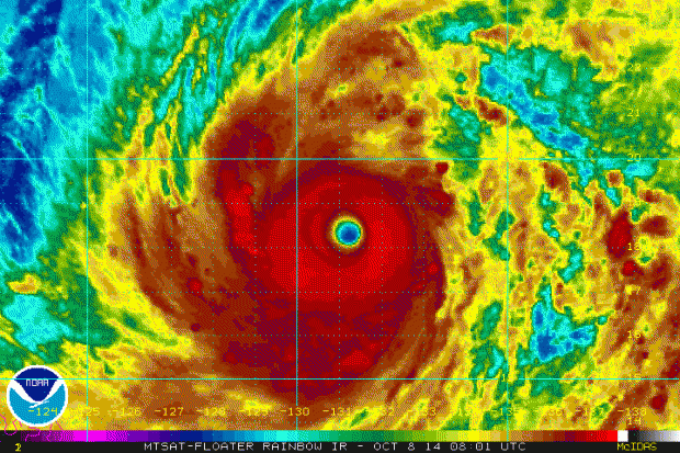
Dissecting Typhoons
Being one of the most vulnerable countries to extreme weather events, we are also in the frontline when it comes to destructive typhoons. To understand this natural hazard, let us familiarize ourselves with the different parts of a typhoon.
Eye
The eye of a typhoon is an area with the lowest air pressure, which can be as much as 15% lower than the pressure outside it. It may vary in shape, which can sometimes be a circle, an ellipse or oval. Its diameter also changes in time, but usually shrinks as a typhoon intensifies.
While many people think the eye is the deadliest part of a typhoon, it is the calmest. In strong tropical cyclones, this area is characterized by light winds and clear skies. For weaker cyclones, the eye is less defined and is usually covered by dense, high and thick clouds.
The eye or the center is helpful for weather forecasters and meteorologists because it serves as the reference point in plotting the typhoon’s location. The formation of an eye is also used as an indicator of the increasing strength of a tropical cyclone.

Eye wall
Surrounding the eye is the eye wall, where the severe weather occurs. It is the innermost ring of convection near the center of the typhoon, packing the fiercest rains and most intense winds.
The National Oceanic and Atmospheric Administration (NOAA) says this is the zone where surface winds reach their highest speed, bringing the strongest thunderstorm activity.
According to the State Climate Office of North Carolina, the contraction or expansion of the eye wall can cause changes in wind speed and storm strength. As a typhoon grows and changes, it can build concentric eye walls that replace the original eye wall.
Eye Wall Replacement
While most typhoons have a single eye wall, powerful and mature typhoons acquire double eye wall structures. Typhoons with double eye walls often undergo a process called “eye wall replacement cycle”. This occurs when a new eye wall develops and replaces an existing one.
According to the Hong Kong Observatory, this cycle begins with a concentrated ring of convection that develops outside the eye wall. It will then circulate inward, leading to a double-eye wall structure. The inner eye wall dissipates while the other intensifies and moves inward.

Spiral Rain Bands
Spiral rain bands are found outside the eye wall. NOAA defines rain bands as long, arching bands of clouds and thunderstorms that spiral out of the eye wall. Dense bursts of rain and winds are often associated with these bands. Also referred to as “buntot ng bagyo”, rain bands form the outermost fringes of the typhoon structure.
Sources:
PAGASA
NOAA
NCSU
Hong Kong Observatory
American Meteorological Society
World Meteorological Organization
Latest Advisories
