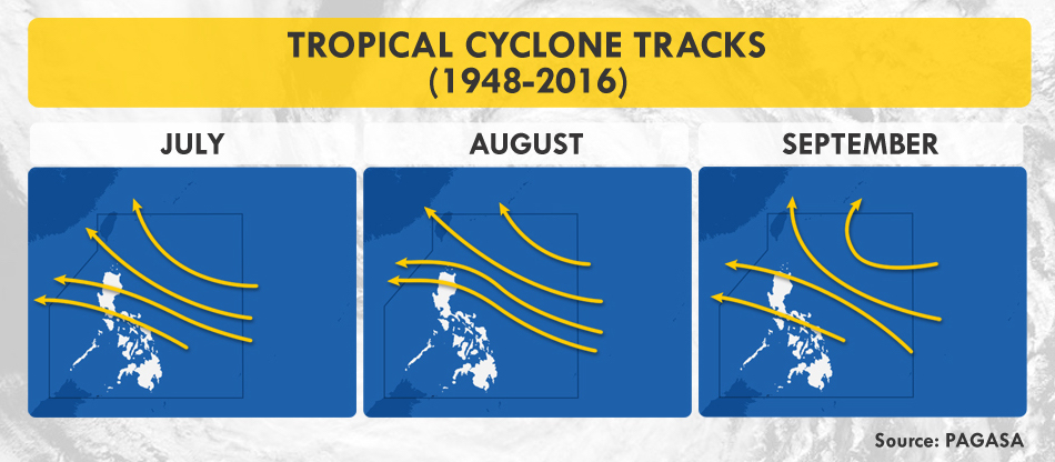
Managing the rainy season this year is vastly different from the previous ones as the Coronavirus Disease 2019 (COVID-19) continues to pose threats on the country’s public health, economy, and environment. During this time, tropical cyclones, combined with the enhanced southwest monsoon (habagat), are expected to bring floods, storm surges, destructive winds, and landslides which may hamper efforts in curtailing the spread of the virus. According to the Philippine Atmospheric, Geophysical and Astronomical Services Administration (PAGASA), 6 to 10 cyclones may enter the Philippine Area of Responsibility (PAR) from July to August. Additionally, there is a 50% chance that La Niña may develop in the last quarter of the year, bringing wetter conditions in the eastern section of the country.
 Typhoon Season. Two tropical cyclones have traversed the PAR since the first COVID-19 case in Manila on January 30. Typhoon Ambo, internationally known as Vongfong, made landfall six times on May 14 and 15, while Tropical Depression Butchoy hit the landmass twice on June 11. Both pummeled the coronavirus-stricken Luzon.
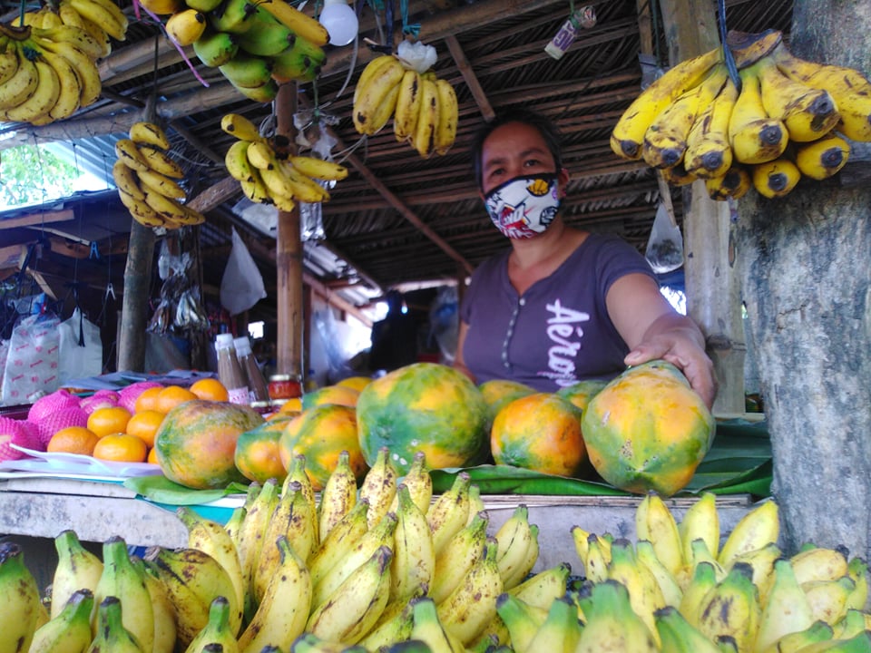
Aylen Labiano, who has been selling agricultural products beside an ecotourism road in Lucena, Quezon for nearly a year now, recounts in Filipino how Bagyong Ambo impacted her livelihood. “The recent cyclone devastated vegetation and banana trees, which prompted suppliers and sellers to raise prices. But people want low-cost food since a lot of them lost their jobs, and the situation has not yet normalized. If typhoons continue to ravage our livelihood, we will not be able to make ends meet.”
 Agricultural Uncertainty. Agricultural loss due to Typhoon Ambo is estimated at Php1.37B.
19-year old Carl Ian Pedregosa from San Francisco, Quezon shares how his family monitored the news to prepare for the typhoon. “But when the rains arrived, we experienced power outage, which lasted for more than a week. Some coconuts, which were supposed to be extracted for oil, also fell during the storm. We fed them to the hogs instead.” Pedregosa also worries about how power interruptions can not only make it difficult for his family to stay updated, but also disrupt his education in the coming school year, especially with academic institutions planning to utilize online learning.
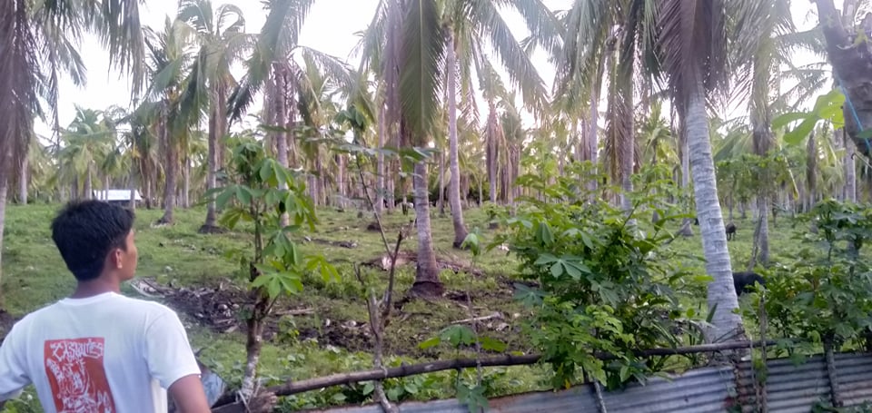 Felled coconut trees in Quezon Province, one of the top agricultural producers of copra in the country.
 PAGASA Cyclone Forecast
Overwhelming Complications
While studies say that rain may help dilute the virus on contaminated surfaces, it also favors other diseases that may strain our healthcare system.
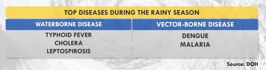 Monsoon Diseases. With the rains comes a downpour of diseases, ranging from the easily curable, such as diarrhea and cough, to the downright deadly, including leptospirosis and typhoid fever. Meanwhile, the World Health Organization (WHO) clarifies that there is still no evidence supporting the possible transmission of COVID-19 through mosquitos and houseflies. To date, no peer-reviewed studies have proven that the ongoing seasonal change has weakened the potency of the virus, and if it can interact with other viruses to develop worse symptoms.
But the real problem lies with how symptoms of monsoon diseases are almost similar to those of COVID-19’s. “Whether people tested positive or negative for COVID-19, we will need to test them for other possible diseases which will make the process longer,” states Dr. Generoso Roberto of the Philippine Society of Public Health Physicians (PSPHP).
The Department of Health (DOH) targets to license 65 COVID-19 testing laboratories by the end of July to test 1.5 to 2% of the population. To date, there are 62 accredited labs with a rated testing capacity of 50,000 daily, prioritizing suspect cases, individuals with travel history, and healthcare workers with possible exposure, whether they are symptomatic or asymptomatic. However, there is still a gap between rated and actual capacity with 12,000 to 16,000 people tested a day due to manpower and supply chain issues— problems that arise globally.
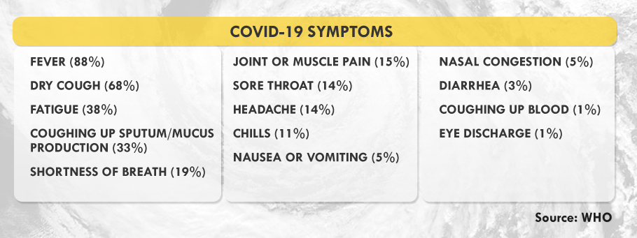 Confirmed Symptoms. The United Kingdom has included anosmia, or loss of taste or smell, as a predictor for COVID-19. Experts say that patients infected with COVID-19 usually transmit the disease before their symptoms manifest, their ability to infect peaking until the third day after symptoms start showing.
“We also need to plan where we’ll be admitting patients diagnosed with other diseases if certain hospitals are designated as COVID-19 treatment sites,” Dr. Roberto explained. Meanwhile, people living in rural areas, especially in remote islands, will face the challenge of transporting patients and doctors to the barrios during the typhoon season. “This means that patients can develop severe symptoms by the time they’re brought to healthcare facilities,” Dr. Roberto explained.
Though virtual healthcare seeks to keep patients at home, the system is not inclusive of, and accessible among the marginalized. According to the Speedtest Global Index, upload and download speeds for mobile and fixed broadband in the country are still below the global average. The Social Weather Stations (SWS) also shows that only 22.4% of Filipino families in the country owns a personal computer at home.
Rising Tide of Vulnerabilities
The country is still on its first wave of COVID-19 cases when the government gradually eased quarantine measures, allowing some businesses to reopen. Though this move aims to save the economy from socioeconomic impacts, such as unemployment and hunger, it may also worsen, not only the health crisis, but also disaster risks.
“We need to do scenario building or disaster imagination so we can prepare for complex emergencies,” says Science and Technology Undersecretary Renato Solidum, Jr. in Filipino. Government and private sectors should have continuity plans for their public service and businesses since the pandemic may coincide with hazards that often transpire in the country, such as earthquakes, tsunamis, and volcanic eruptions.
On March 11, days before the Enhanced Community Quarantine (ECQ) in Luzon, volcanologists placed Mount Kanlaon in Negros Island under Alert Level 1, prohibiting people around its 4-kilometer-radius danger zone for possible sudden phreatic eruptions. A series of volcano-tectonic quakes has been observed since June 21. Meanwhile, Mayon Volcano has been under Alert Level 2 since March 2018.
Urbanized cities are highly exposed both to the pandemic and the negative impacts of natural hazards due to their dense structures and population. According to Solidum, the government’s Balik-Probinsya program may be a good solution to decongest cities as long as comprehensive safety protocols are strictly employed. This program, institutionalized through Executive Order No. 114, seeks to encourage people, especially the informal settlers, to return to their home provinces.
Metro Manila, considered as the seat of government, is no exception to looming catastrophe. Here lies the biggest portion of the West Valley Fault (WVF), an active earthquake generator traversing Bulacan, Quezon City, Marikina, Pasig, Taguig, Muntinlupa, Rizal, Laguna, and Cavite. These areas are part of the Greater Metro Manila Area (GMMA), a megacity with an estimated population of 20 million. About 35% of its populace are informal settlers, many of them living below poverty line.
WVF’s massive earthquakes occur every 400 to 600 years. Its last movement that caused a magnitude 5.7 quake was in 1658 or 362 years ago. According to a joint study by Australia and the Philippines, the fault’s next movement may produce a magnitude 7.2 earthquake, resulting in 34,000 deaths due to collapsed buildings—and an additional 18,000 fire-related fatalities in the metropolis. Furthermore, infrastructures, lifelines, and about 40% of residential buildings are likely to be heavily or partially damaged, causing 2.3 trillion pesos worth of damage. The management of such a huge disaster requires close coordination, which the current pandemic hampers.
If protocols are not properly implemented and followed, evacuation centers during disasters coupled with monsoon diseases may be a breeding ground for more health risks. A person with COVID-19 may infect dozens of people, including Disaster Risk Reduction and Management (DRRM) officers who are on the frontline during rescue and relief operations.
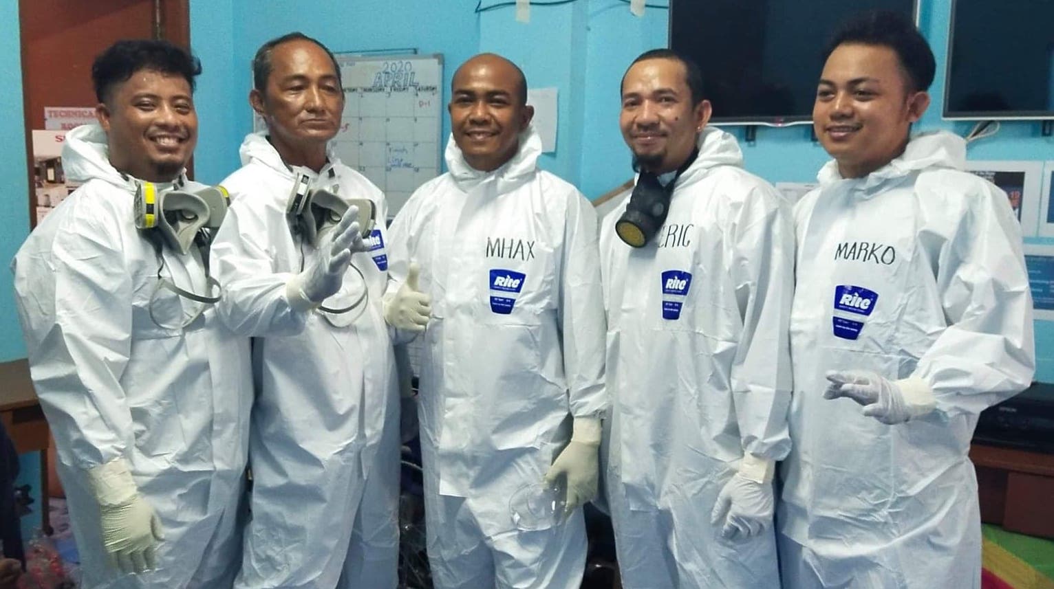
One of which is Alex Pimentel, a DRRM officer in Batangas City, who tested positive for the disease in April. “Parang nandidiri ang ibang tao sa community, lalo na when I tested positive,” he shares. (When I tested positive, people in the community avoided me like the plague.)
DRRM offices help by providing transportation for COVID-19-related patients, manning centers for Persons Under Monitoring (PUM), and disinfecting public spaces, among others. But if a natural disaster strikes, people like Alex will even have a more difficult time doing their duty. “It will be hard for the DRRM frontliners responding with merged Search and Rescue and COVID-19 personal protective equipment. We also worry about funds because we’ve already spent so much during the Taal eruption, assisting 11,000 evacuees, followed by the pandemic response.“
 Nasugbu, Batangas LDRRMO
The Need for Disaster Imagination
Solidum explains that disaster imagination means preparing for worst-case scenarios and their possible impacts. “People and the Local Government Units (LGUs) should know the hazards in their areas so they can plan appropriately. What if an earthquake transpires? What are its impacts? Have we identified the vulnerable population? Where are we bringing them?”
A study conducted by the International Organization for Migration (IOM) in 2014 exposed that more than 90% of evacuation sites in Eastern Samar were partially or completely devastated during the onslaught of Typhoon Haiyan, locally known as Yolanda. These were churches, schools, and community centers, which were identified by LGUs as safe.
On June 13, the Office of Civil Defense (OCD) provided LGUs with guidelines so they can meet the health standards of the COVID-19 National Task Force in conducting online Pre-Disaster Risk Assessment. This allows LGUs to prepare their inventory of resources, logistical requirements, relief packs, and evacuation centers. “If we conduct pre-emptive evacuation, we see to it that everybody is protected. We should be observing social distancing and we limit the number of people in the evacuation centers. We also see to it that our responders are protected,“ says OCD’s Operations Service Director Harold Cabreros.
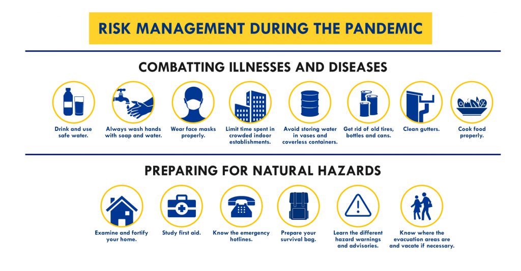
Risk Management during the Pandemic
The Philippine Institute of Volcanology and Seismology (PHIVOLCS), PAGASA, and the Mines and Geosciences Bureau (MGB) have developed Hazard Hunter, a tool that Filipinos can use to assess seismic, volcanic, hydrometeorological, and climatological hazards in their locations. It is free and readily- available online, especially useful for property owners, buyers, land developers, planners, and other stakeholders.
It is also important to know what to do before, during, and after several natural hazards.
 Graphics by Jearom Andre Martinez
This global crisis is not just about adapting to changes, but also preparing for complex emergencies. With inclusive, sustainable solutions, everyone—even the weakest—can be empowered to rise up to the challenges.
Assistance and additional reports from: Fritzjay Labiano, Relly Bernardo (Antipolo PIO), Vic Simoun Montoso, Mark Cashean Timbal (OCD), Lilia Malabuyoc (OCD)
It happened on a Saturday morning. Heavy rains continued to pour as a number of cars were already floating in water. A few hours later, people were soaked in neck-deep floods, while some were stranded on roads, bridges and roofs. Rich and poor alike, survivors cried for help as they witnessed their prized belongings swept away by raging floods. Such was the scene that unfolded at the height of “Ondoy,” the worst storm to hit Metro Manila in almost four decades.
BACKGROUND
On September 24, 2009, a low-pressure area inside the Philippine boundary developed into a tropical depression and was named “Ondoy,” with the international name Ketsana. Two days later, it intensified into a tropical storm, which made landfall in the boundary of Aurora and Quezon, and crossed Central Luzon for 12 hours. On the same day, it enhanced the habagat, which brought rains concentrated in Metro Manila, Central and Southern Luzon, and some parts of Visayas and Mindanao.

source: PAGASA
At 455 millimeters, the amount of rain accumulated in Metro Manila within 24 hours surpassed the normal monthly amount in the metropolis, according to PAGASA.
IN THE WAKE OF ONDOY
“Ondoy” exited the Philippine boundary on September 27, 2009 leaving a wake of devastation

source: NDRRMC
Based on the final report of the National Disaster Risk Reduction and Management Council (then the National Disaster Coordinating Council), Tropical Storm Ondoy affected 4.9 million people in the country. The enhancement of the habagat resulted to floods in 1,786 barangays in 26 provinces, and landslides in some parts of Cagayan, Pampanga and Camarines Sur. The catastrophic storm also took 464 lives, injured 529 and caused 37 unaccounted for. Damage to infrastructure and agriculture amounted to P11 billion.

LESSONS
On the seventh anniversary of the disastrous storm, we visited Marikina, one of Metro Manila’s hardest-hit areas. We asked survivors to share with us some of the lessons that the Ondoy tragedy has taught them. Here are some of their answers:
1) Preparedness is a must.

“Sobrang takot. Kapag may nagbabaha na ngayon, nagre-ready na kami. Nag-aabang na kami, baka sakaling bumaha, ay lumikas na tayo sa matataas na lugar. Alam na namin ang gagawin namin kapag andiyan na eh. Hinahanda namin ‘yung mga gamit namin. May plano na. ‘Yung kahandaan na kasi noong una, biglaan yun. Natakot din kami. Hindi namin alam ang gagawin namin.”
(It was frightening. Now, when flood occurs, we start to prepare. We monitor updates, while planning our evacuation to higher grounds. We were afraid before but now, we already know what to do.)
– REY BAYAOA, a 52-year-old shoemaker in Tumana who saved his family of six during Ondoy

“Kasi dati ang ugali namin, pateka-teka kami. Once na nagkakaroon ng bagyo, kampante ‘yung mga tao na hindi tataas ‘yung tubig o kaya, kakayanin ng bahay nila. Pero ngayon, kapag sinabing may bagyo at nag-signal number three na sa Metro Manila, automatic, ‘yung mga gamit na kayang iakyat, tinataas na,”
(We were complacent before. We were confident that our homes could protect us from flood. But now, we automatically move our things to higher ground, especially when signal number 3 is raised in Metro Manila.)
– KATRIN ABELLA, 24-year-old employee who recalled losing four neighbors due to leptospirosis that became rampant after Ondoy.
2) Be familiar with warning systems.

“Mahalaga, para makapaghanda ang mga tao. Meron na rin dati, nag-a-alarm. Kapag 15, alert ‘yun. May maiksi, may mahabang tunog. Kapag mas mahaba, malapit na sa critical ‘yun, mga 17 na yun. Tsaka kapag matagal ang ulan, nakabantay na kami. Ang alam ko, kapag hindi malakas ang hangin, habagat yun. Kapag may ulan at hampas ng hangin, bagyo. Okay naman ang PAGASA, maganda ngayon. High-tech na.”
(It is important that we know various alarms from the river warning system; a shorter siren means alert level or a river height of 15 meters. A longer siren means an almost critical level, close to 17 meters. When the rains are prolonged, we are already on the lookout. As far as I know, habagat has weaker winds while a tropical cyclone has stronger ones. PAGASA is instrumental since they have more advanced technology now.)
– ROMEO BUENAVENTURA, 58-year-old resident of Barangay Barangka who recalled how they witnessed the sudden rise of Marikina River in September 2009
3) Never be complacent.
“’Yung bahay namin, wala pang one kilometer away from the Marikina River… Sina mama, naging kampante sila na hindi kami aabutin ng baha. ‘Yung bahay kasi namin hanggang third floor, maliban dun, first experience naming ‘yun na sobrang baha. Sa mga dati naming bahay, kapag sinabing baha, hanggang tuhod, hanggang bewang, hindi naming in-expect na kapag sa Marikina pala, floor by floor ng bahay ang pinag-uusapan. So hindi sila lumikas… may dumating na chopper mula sa LGU tapos iniligtas sila.”
(My mom lives one kilometer away from the Marikina River. My mother was confident since our house had three floors. Before, floods only reached up to our knees and waists. We were not used to the kind of massive flood Ondoy brought so they did not evacuate. Fortunately, a chopper came to rescue them.) – KATRIN ABELLLA
4) We must care for the environment.

“Yung mga ilog, ginagawa ng ibang tapunan. Kalinisan dapat. Dapat tinatapon sa lagayan ng mga basura. Hindi sa mga ilog.”
(Some people throw garbage into the rivers. We must observe cleanliness. We should manage wastes properly.)
– GENARD GUEVARRA, 21 years old and lives just a few meters away from the Marikina River
“Kailangan talaga may pagmamahal sa kalikasan. ‘Wag babuyin. ‘Wag lagyan ng basura. Dito ang takbuhan ng ulan eh, mula sa Quezon City at Montalban. ‘Yung mga basura, inaagos.”
(We should love our environment. We shouldn’t degrade it. Rubbish from Quezon City and Montalban are brought here to our city through the river.) – ROMEO BUENAVENTURA

5) Cooperation matters.
“Gan’un na lang kaimportante ang kooperasyon ng mga LGUs sa mga kalamidad na kagaya ng Ondoy kasi nga sila ‘yung may kontrol. Kumbaga, sila ‘yung medium ng mga tao para malaman kung gaano na ba kataas ‘yung tubig sa ilog o kung kailangan na ba talaga lumikas. Nakadepende rin sa kanila ‘yung safety ng mga tao, halimbawa, mali sila ng information na ibinigay… mas maraming mamamatay.”
(Cooperation among local government units is important during calamities since they have control. They also inform us how high the river is, or if we already need to evacuate. Our safety depends on them. If they give us wrong information, lives will suffer.) – KATRIN ABELLA
6) There is hope after a tragedy.
“Yung mga gamit, kahit paano, unti-unti namin na-recover. Syempre, hindi naman mabibigla na bibili ulit. Ang mahalaga, unti-unting bumabangaon.”
(We cannot easily replace our lost possessions, but we are trying to recover, little by little. What matters is that we will stand up again.) – REY BAYAOA

7) Keep the faith.
“Anim kami. Wala namang napahamak sa amin. Awa ng Diyos, nailigitas ko lahat ng pamilya ko. Kumpleto pa rin kaya ngayon. Kapag umuulan, nakahanda na kami bilang mag-anak.”
(There are six of us in the family. No one was hurt. By the grace of God, I was able to save my family members. Now, when it rains, our family automatically prepares.) – REY BAYAOA


More than half a decade has passed, and still, memories from the Ondoy calamity burn clear in people’s minds. But more important than the tragedy are the valuable lessons we’ve learned to make sure that we don’t suffer such great devastation and loss ever again.


As we begin the countdown to ending another year, we take a look at the weather events that made 2014 memorable, weather-wise.
Situation: Tropical Cyclones
This year, a total of 19 tropical cyclones entered the PAR (Philippine Area of Responsibility).
The first was Agaton, which made its entry last January 17. Though it was identified as a Tropical Depression, the lowest category for cyclones, Agaton caused severe flooding in Eastern Visayas, Northern Mindanao and the CARAGA region.
According to the National Disaster Risk Reduction Management Council (NDRRMC), 244,344 families were affected in more than a thousand villages in 16 provinces. There were at least 1,147 houses destroyed and more than one thousand partially damaged. All in all, damages in infrastructure and agriculture were estimated at more than 500 million pesos.
Trending Typhoons
From the 19 tropical cyclones that entered PAR, 10 were under the Typhoon category with wind speeds of 118 to 220 kilometers per hour.
1. Domeng
2. Florita
3. Glenda
4. Henry
5. Jose
6. Luis
7. Paeng
8. Neneng
9. 0mpong
10. Ruby
From these 10 typhoons, Ompong and Ruby could be categorized as Super Typhoons.
Entering PAR on October 7 and making its exit on October 11, Ompong, with international name Vongfong, was classified by the U.S Joint Typhoon Warning Center as a Category 5 Super Typhoon.
Packing maximum sustained winds of 215 kilometers per hour and gustiness of 250 kilometers per hour, Ompong—thankfully— did not hit the country as it re-curved towards Mainland Japan.
Related articles: Gazing into the Eye of 2014’s Strongest Typhoon
Strongest Typhoon for 2014 still inside PH

But Typhoon Ruby was totally different story. With the fitting “Hagupit” as its international name, Ruby entered the country’s boundary on December 3 and made its way out on December 11. With maximum sustained winds of 215 kilometers per hour and gustiness of 250 kilometers per hour, Ompong made five landfalls.

First landfall: Dolores, Eastern Samar
Second landfall: Cataingan, Masbate
Third landfall: Torrijos, Masbate
Fourth landfall: Laiya, Batangas
Fifth landfall: Lubang, Island
The NDRRMC filed a total of more than four million residents affected in Regions III, IV-A, IV-B, V, VI, VII, VIII, CARAGA and the National Capital Region. 18 deaths were recorded while injured persons reached up to 916. Ruby damaged mostly infrastructure and agriculture—the total cost amounting to more than 5 billion peos.
Due to its devastating impact, a state of calamity was declared in San Pablo City in Laguna, Batangas, Albay, Camarines Sur, Catanduanes, Masbate, Naga City, Juaban and Gubat in Sorsogon, Sorsogon City, Aklan; Maayon, Dumalag and Panay in Capiz; and Northern and Eastern Samar.
Because fatal storm surges brought by Typhoon Yolanda in 2013 made the public more aware of this weather phenomenon, Ruby kept Filipinos on their toes.
Coincidentally, while Ruby was inside PAR, an astronomical event happened. This was the Full Moon phase, which caused higher tidal variations due to our satellite’s strong gravitational pull.
Weather forecaster Chris Perez explained that higher waves were expected due to the combination of storm surge and the effects of the Full Moon.
Watch the Interview: Storm Tide
Scorching Season

PAGASA officially announced the start of the Hot and Dry season last March 26. Easterlies, the prevailing wind system during this time, brought hot and humid weather to the country.
Aside from the easterlies, this season’s indicators included the presence of the High Pressure Area (HPA), which brings good weather conditions, the termination of the northeast monsoon, and the increase in temperatures.

Upon the onset of the Hot and Dry season, the country undeniably experienced a number of scorching days that were especially evident in the Luzon area.
In March, Tuguegarao recorded a maximum temperature of 37.9 degrees Celsius. But its days got hotter in April and May, which brought in temperatures of 39 degrees and 39.8 degrees consecutively.
Meanwhile, the Science Garden in Quezon City documented a high of 36.7 degrees Celsius in May.
The Unpredictable El Niño

Within this year, the El Niño phenomenon became a hot topic during the hot season as PAGASA continued to monitor the ups and down of sea surface temperature.
From April 21 to 28, PAGASA recorded a substantial increase in the sea surface temperature anomaly from 0.2 to 0.4 degree Celsius. It was then forecast that El Niño might reach its peak in the last quarter of 2014.
But with the recent report from the International Research Institute for Climate and Society, only weak El Nino conditions were observed in November and December.
Here comes the rain!

The rainy season in the country officially started in June 10. Before declaring the onset of this season, PAGASA first made sure that the following requirements were met:
• Daily thunderstorm activity
• Prevailing southwest monsoon
• 5-day period with a total rainfall of 25 millimeters or more in three consecutive days.
Come on, Amihan!

The Amihan season was officially declared by PAGASA on October 16. The northeast monsoon or amihan is the prevailing wind system, bringing light rains to its affected areas. It also has cold and dry characteristics, resulting to colder mornings.
At this time of the year, a gradual decrease in temperatures was observed in different parts of the country.

Winter Solstice
Winter season in the northern hemisphere officially started on December 22 this year. This also signaled the start of experiencing longer nights and shorter days in the Philippines.
During the winter solstice, the northern hemisphere leans the farthest distance from the Sun, causing longer nights and lower temperatures for those in the northern hemisphere. The opposite happens in the southern hemisphere where people experience the longest day.
Related article: Winter has arrived
Although a lot has happened this year, there’s more to come this 2015. So brace yourself for those inevitable storms, but remember to keep to the sunny side of the street. With all the changes the weather brings, one thing stays the same: the Filipino brand of resilience that knows no bounds.
Christmas is about gift-giving and celebrating with families and friends. This year, aside from the parties and presents, we must also prepare our emergency kit and rainy day essentials as #NinaPH threatens to affect the country.
According to the Philippine Atmospheric Geophysical and Astronomical Services Administration (PAGASA), an average number of 1 or 2 tropical cyclones enter the PAR during the month of December. PAGASA added that these cyclones have a higher chance of hitting the landmass during ber months due to the effect of the northeast monsoon or amihan that directs the cyclones towards the country–which means that our holidays may be as merry as they are stormy. Take a look at some of the tropical cyclones that dropped by our country during the holiday season in the last few decades.

DINANG
This tropical cyclone started as a cloud cluster spotted in Guam, which later developed into a tropical cyclone on the 22nd of December, 1981. From a tropical depression, it was named “Dinang” as it intensified into a tropical storm. Dinang initially moved west-northwest but changed its course to a westward direction due to the influence of a ridge of a high pressure area.
Dinang gained strength and intensified into a typhoon with maximum sustained winds that reached 185 kilometers per hour. It lashed the northern tip of Samar on Christmas Eve. It crossed the southern portion of Bicol Region, through the Bondoc peninsula, Marinduque and Mindoro. Dinang was located at 120 kilometers south of Metro Manila on December 26, which, according to PAGASA was its closest distance from the country’s capital.
It then moved towards the South China Sea, and after 48 hours of reaching its peak intensity, it weakened and dissipated.
By virtue of the Proclamation No. 2150, a state of public calamity in the provinces of Northern Samar, Masbate, Oriental Mindoro and Romblon was declared due to the damage brought by Dinang.
APIANG
Apiang became a tropical storm in the afternoon of December 23, 1988. It threatened Bicol, Quezon, Aurora, Quirino, Isabela and Cagayan. However, other weather systems weakend and slowed it down. PAGASA noted its clockwise loop on December 25, and was downgraded into a tropical depression. By the morning of December 26, Apiang already dissipated.
PURING
This cyclone crossed the PAR from the 23rd up to the 29th of December in 1993. Moving west-northwest, it made its way towards the Surigao-Leyte Area and passed through Bohol, Cebu, Negros, Panay and the Calamian Group of Islands.
Signal 3 was hoisted over Surigao Provinces, Dinagat Island, Agusan Del Norte, Camiguin Island, Southern Leyte, Bohol, Cebu, Siquijor, Negros, Panay and Northern Palawan. Signal Number 2 was raised over Agusan Del Sur, Masbate, Misamis Provinces, Albay, Romblon, Sorsogon, Burias Island, Lanao Provinces, Davao Del Norte, Davao Oriental, Bukidnon, Zamboanga Del Norte, the rest of Palawan, Mindoro and the rest of Visayas. Metro Manila, Bataan, the rest of Southern Luzon, Lubang Island and the rest of Mindanao were put under Signal Number 1.
157 people were recorded dead while 276 were injured.

Typhoon Puring was the 32nd tropical storm that hit the country in 1993. This was a record-breaking season because normally, an average of only 19 to 20 tropical cyclones enters the PAR each year.
TRINING
On December 25, 1995, Trining formed into a tropical depression in the South Philippine Sea. It moved eastward close to the Southern Leyte – Surigao del Norte area but later changed course. Moving northeast, it exited the PAR through the northern part of the Philippine Sea.
ZIGZAG
From an active low pressure area (LPA) spotted east of Bicol, Zigzag developed into a tropical depression on Christmas morning in 2003. While moving westward, it slowed down in the evening of the 26th. Public Storm Warning Signal Number 1 was raised over the Bicol Region, Samar, Leyte, Biliran, Bohol, Cebu, Negros Oriental, Siquijor, Surigao Provinces, Agusan del Norte and Camiguin. Zigzag moved towards Visayas, crossing the southern part of Samar and Leyte. After hitting the land, it weakened into a low pressure area in the morning of December 28.
QUINTA
As a low pressure area, this weather disturbance moved over the east of Northern Mindanao where it developed into a tropical depression on December 25, 2012. Quinta intensified into a Tropical Storm and was given an international name Wukong, which means a famous hero in a Chinese Story.
Nearing the landmass, Signal number 2 was declared over Eastern Samar, Leyte, Southern Leyte, Dinagat Province, Siargao Island, Western Samar, Cebu, Camotes Island, Bohol, Biliran, Surigao del Norte, Dinagat Island, Sorsogon, Masbate, Ticao and the northern part of Negros Oriental.
Meanwhile, Signal number 1 was raised over Occidental & Oriental Mindoro, Northern Palawan, Calamian Group of Islands, Cuyo Island, Marinduque, Romblon, Lubang Island, Aklan, Capiz, Antique, Iloilo, the rest of Negros Oriental, Guimaras, Camiguin, Siquijor, Burias Island, Camarines Sur, Catanduanes, Agusan del Norte, Agusan del Sur and Misamis Oriental.
Quinta crossed the region of Visayas where it made its landfall 7 times.
1st landfall: Eastern Samar
2nd landfall: Albuyog, Leyte
3rd – 5th landfall: Poro Island, Pacijan and Catmon (all in Cebu Province)
6th landfall: Northern part of Roxas
7th landfall: Coron, Palawan
After its series of landfalls, Quinta finally weakened into a tropical depression before it headed to Palawan. It moved towards the West Philippine Sea and further weakened due to the cold air intrusion from the amihan over the west of Palawan.
In a Situational Report of the NDRRMC dated on December 31, 2012, 44 incidents were monitored: two maritime incidents in Regions IV-A, IV-B, V and VIII; one drowing incident in Region V; one missing person and two falling tree incidents in Region VIII; one capsized banca in CARAGA; and thirty-three flooding incidents in Regions V, VI and VIII.
More than 50 thousand families were affected in Regions IV-B, V, VI, VII and VIII. Twenty people were reported dead, three were injured and four were missing. Quinta damaged more than 5 thousand houses in Regions VI, VII and VIII. Cost of damage amounted to more than 200 million pesos in infrastructure and agriculture.
Quinta’s intensity has brought storm surge over Cebu, Borongan City and Merida, Leyte on December 26, 2012 in which 2 casualties were recorded by the Nationwide Operational Assessment of Hazards (NOAH).
Preparation in the midst of Celebration
The tropical cyclones mentioned above are proof that the Yuletide Season does not equate to fair weather— so preparation should always be a part of any celebration. This way, even if Christmas comes in a stormy package, you’ll still be able to enjoy it by staying safe and secure.
Sources:
PAGASA-DOST | NDRRMC | http://blog.noah.dost.gov.ph/2014/02/04/compilation-of-storm-surge-occurrences-in-the-philippines/ | http://www.gov.ph/1981/12/29/proclamation-no-2150-s-1981/
The National Disaster Risk Reduction and Management Council (NDRRMC) and PAGASA released a list of areas deemed critical as Typhoon Hagupit threatens the Philippines.
As the typhoon approaches, 44 provinces has been put under Alert Level C. These areas may experience 10 to 20 millimeters per hour of rainfall, which translates to heavy to intense rains, bringing heavy damage to agriculture, disruption of electrical power, and threat to travel.
Meanwhile, 6 provinces are expected to experience moderate to heavy rainfall at 5 to 10 millimeters per hour categorized under Alert Level B. Moderate damage to agriculture and risky travel are possible due to wind strength of 30 to 60 kilometers per hour, which is enough to uproot a few large trees and dislodge iron roofing.
Meanwhile, Metro Manila is put under Alert Level A, along with five more provinces. 5 to 10 millimeters per hour or moderate to heavy rainfall is expected with winds reaching up to 30 to 45 kilometers per hour.
Check the complete list below:
