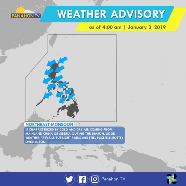
Northeast Monsoon affecting Luzon and Visayas. This weather system will bring cloudy skies with light to moderate rains over Cagayan Valley, Aurora, Quezon, Bicol Region and Eastern Visayas. Partly cloudy to cloudy skies with isolated light rains is expected today over Metro Manila, the rest of Luzon and of Visayas. In Mindanao, partly cloudy to cloudy skies with isolated rainshowers will be experienced which is caused by the Localized Thunderstorms.

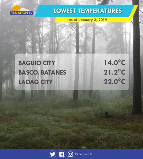
The Northeast Monsoon directly affects the Northern part of Luzon. Aside from the light rains, it also brings cold air which is why some areas in Luzon have been listed as the areas with the lowest temperature as of January 3, 2019.
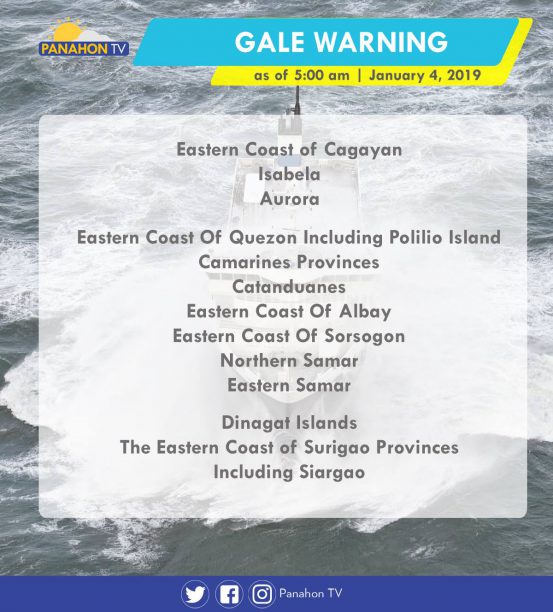
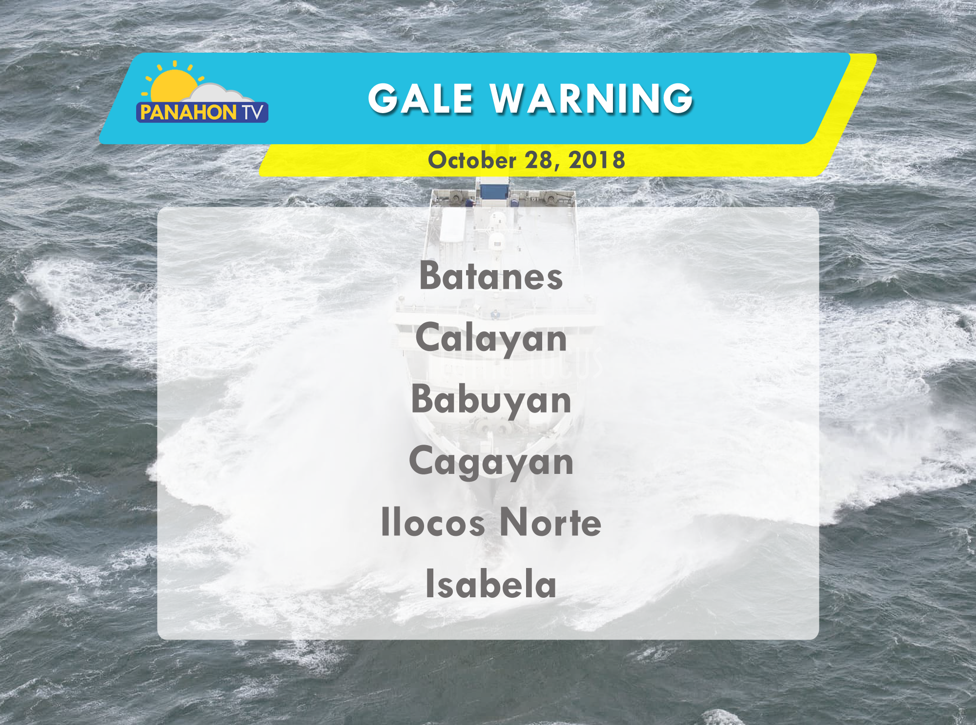
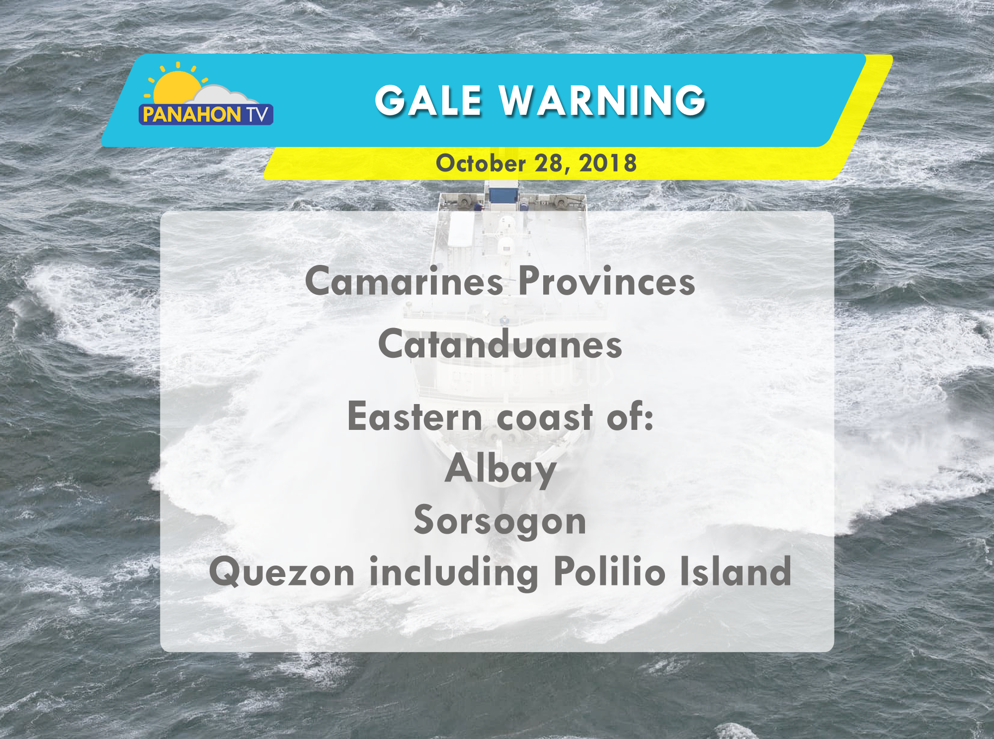
Due to the effects of Northeast Monsoon, gale warning is raised over the Eastern seaboards of Luzon, Visayas and Mindanao. Sea travellers with small sea-crafts are not allowed to travel to the sea due to the rough sea condition.
According to PAGASA Weather Forecaster Cris Perez, there is no weather disturbance being monitored outside the Philippine Area of Responsibility (PAR) within 3 to 5 days. As the start of this year, PAGASA released the list of Tropical Cyclone names for 2019. Mr. Perez says, once a storm enters PAR, it will be given its local name which has an alphabetical order.
Northeast Monsoon affecting Luzon and Visayas. This weather system will bring cloudy skies with only light rains over Cagayan Valley, Cordillera Administrative Region, Aurora and Quezon. Generally fair weather with only partly cloudy to cloudy skies and isolated light rains is expected over Metro Manila, Visayas, and the rest of Luzon. Meanwhile, fair weather condition with only partly cloudy to cloudy skies with isolated rain showers will be experienced over Mindanao.
As the Norhteast Monsoon strengthens and affects the whole area of Luzon and Visayas, sea condition is also affected from this weather system. With this, gale warning is raised over the Easter seaboards of Northern and Central Luzon, Eastern seaboards of Southern Luzon and of Visayas, and Eastern seaboard of Mindanao. Fishing boats and other small seacrafts are advised not to venture out into the sea due to the rough up to very rough sea condition.

According to PAGASA Weather Forecaster Ariel Rojas, there is no weather disturbance being monitored outside the Philippine Area of Responsibility (PAR). But this January there is 0 to 1 possible number of tropical cyclone that may enter PAR or develop into a Typhoon.
The Low Pressure Area (Formerly “Tomas”) is still inside the Philippine Area of Responsibility. At 3:00 a.m. today, it was last spotted at 1,335 km East Northeast of Basco, Batanes. Meanwhile, Northeast Monsoon affecting Northern and Central Luzon. This weather system will bring isolated light rains over Ilocos Region, Cordillera Administrative Region, Cagayan Valley and Central Luzon. The rest of the country including Metro Manila, expect a fair weather condition with only isolated rain showers caused by Localized Thunderstorms.
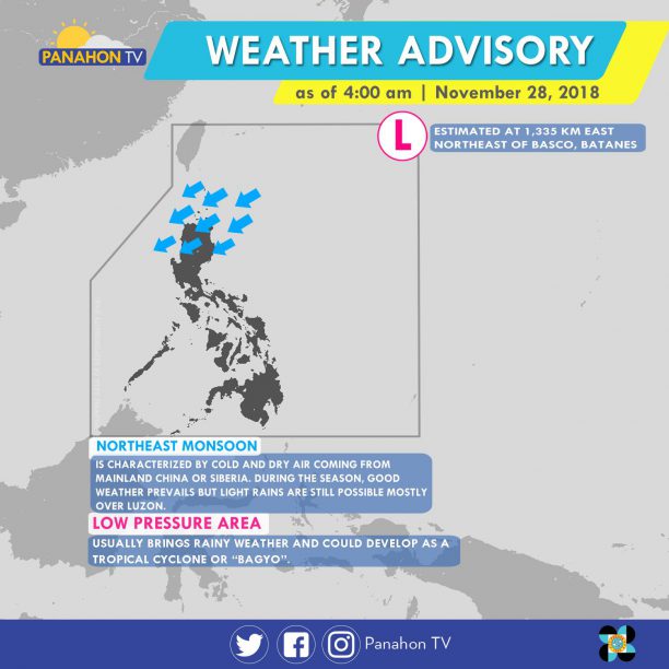
According to PAGASA Weather Forecaster Cris Perez, the LPA is expected to exit PAR anytime today and may dissipate before its exit. He also added that the LPA has no effect on any parts of the country and there are also no weather disturbances being monitored within 3 to 5 days.
At 3:00 a.m. today, the Tropical Storm “Usagi” (Formerly “Samuel”) was last spotted at 795 km West of Southern Luzon. It has maximum sustained winds of 65 kph, gustiness of up to 80 kph and it is moving West at 20 kph. The Tropical Storm has no effect on any parts of the country.
At 3:00 a.m. today, another Typhoon with an international name “Manyi” was located at 1,400 km East of Southern Luzon. It has no effect yet on any parts of the country and it has maximum sustained winds of 15 kph, gustiness of up to 180 kph and it is moving West Northwest at 25 kph. According to PAGASA, it is expected to enter PAR tomorrow evening (November 24) or Sunday early morning (November 25) and once it enters PAR, it will be named on its local name “Thomas”. PAGASA added that base on it’s current track it is not expected to make landfall, but since the distance of the storm is still quite far, there might be some changes on its track.
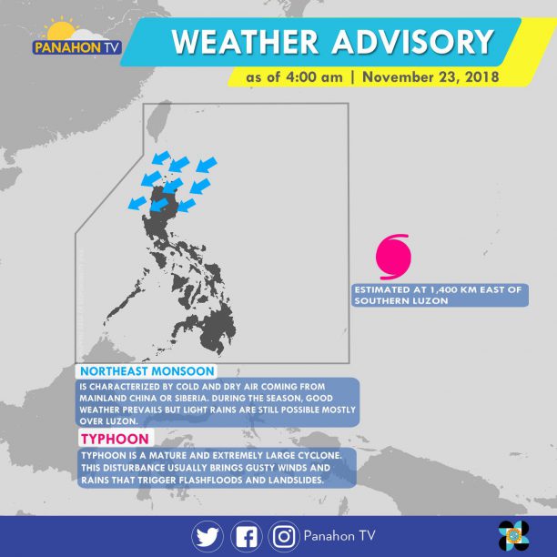
Meanwhile, Northeast Monsoon affecting Northern Luzon and will bring light rains over Cagayan Valley Region and the provinces of Ilocos Norte and Apayao. The rest of Cordillera Administrative Region and of Ilocos, expect a partly cloudy to cloudy skies with isolated rains due to the Northeast Monsoon. In Metro Manila and the rest of Luzon, fair weather condition will be experienced with chances of isolated rains caused by Localized Thunderstorm.
As of 3:00 a.m. today, aLow Pressure Area (LPA) was spotted at 405 km east of Hinatuan, Surigao del Sur. Due to the Trough of the LPA, Eastern Visayas and Mindanao will experience scattered rain showers and thunderstorms. Meanwhile, the Tail-end of a Cold Front affecting Southern Luzon will bring scattered rain showers and thunderstorms in the Bicol Region and Palawan. In Metro Manila and the rest of Luzon, the Northeast Monsoon prevails, bringing isolated light rains. The rest of Visayas will experience isolated rain showers caused by the localized thunderstorms.
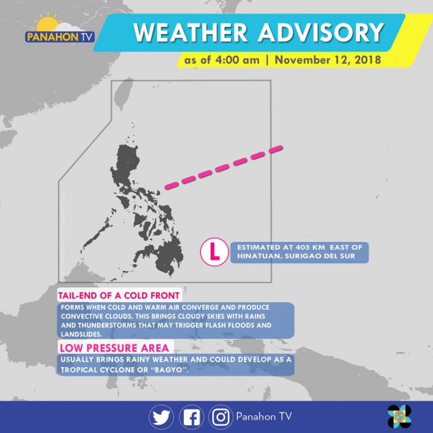
According to PAGASA Weather Forecaster Ariel Rojas, the LPA is expected to hit the landmass of Mindanao tomorrow before exiting Sulu sea. As it crosses the ocean, the LPA is expected to develop into a Tropical Depression and will be named Samuel.
No gale warning is hoisted in any seaboards of the country.
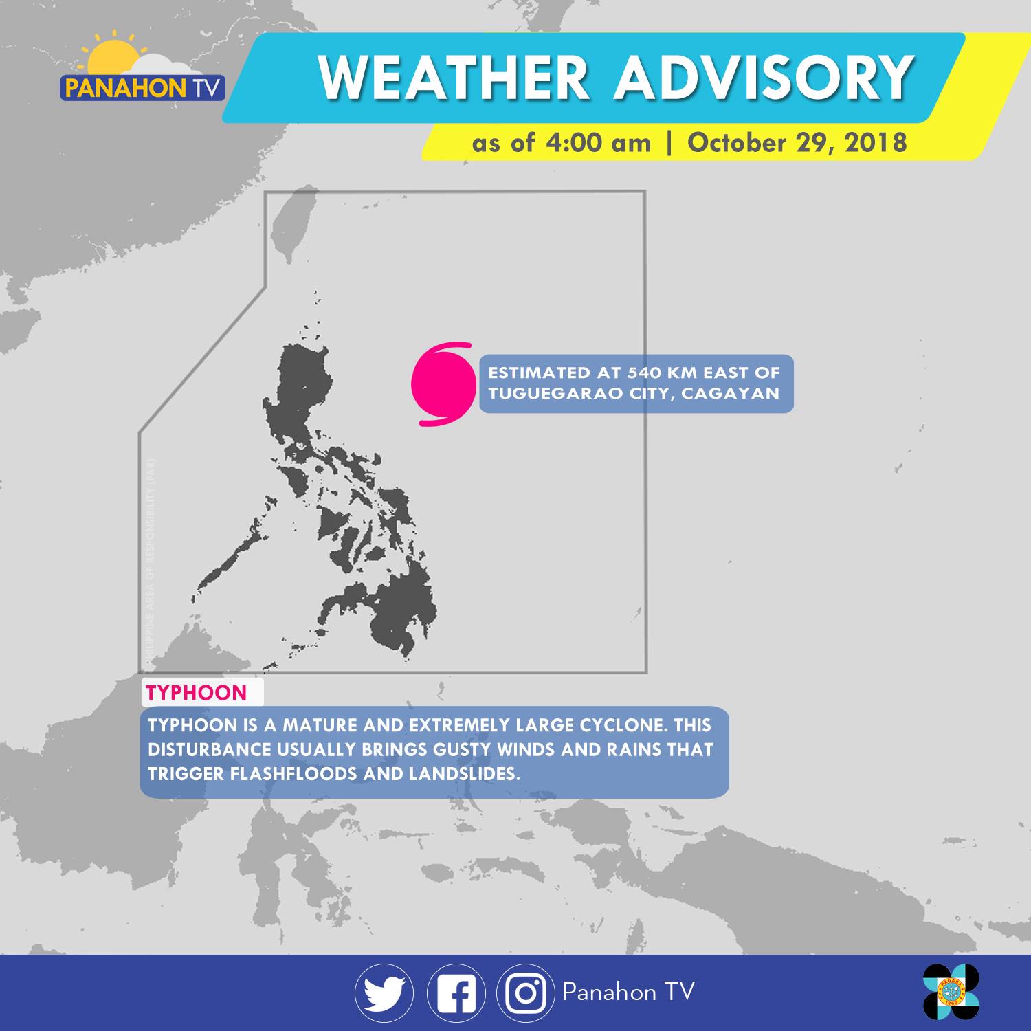
As of 5:00 a.m., Typhoon Rosita was spotted 540 kilometers (km) east of Tuguegarao City, Cagayan. It has maximum sustained winds of 170 kilometers per hour (kph) and gustiness of up to 210 kph. The Typhoon has slightly weakened as it moves westward at 15 kph. It will bring stormy weather or heavy rains with strong winds in Cagayan, Isabela, Quirino, Aurora and Polilio Island. Meanwhile, rains with gusty winds are expected in the Cordillera Administrative Region, Ilocos Region, the rest of Cagayan Valley and Central Luzon, and the provinces of Rizal and Camarines Norte. Due to its trough or extension, Metro Manila, the rest of CALABARZON and of Bicol Region will have cloudy skies with scattered rain showers and thunderstorms. Meanwhile, partly cloudy to cloudy skies with isolated rain showers will prevail in the rest of the country.
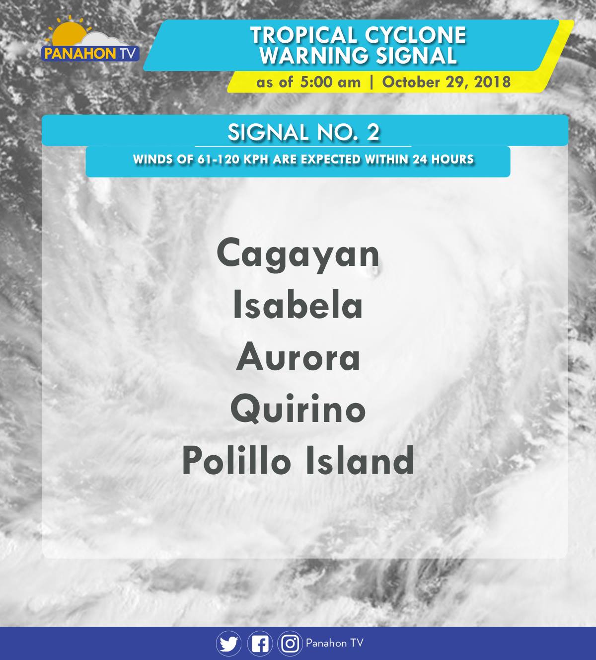
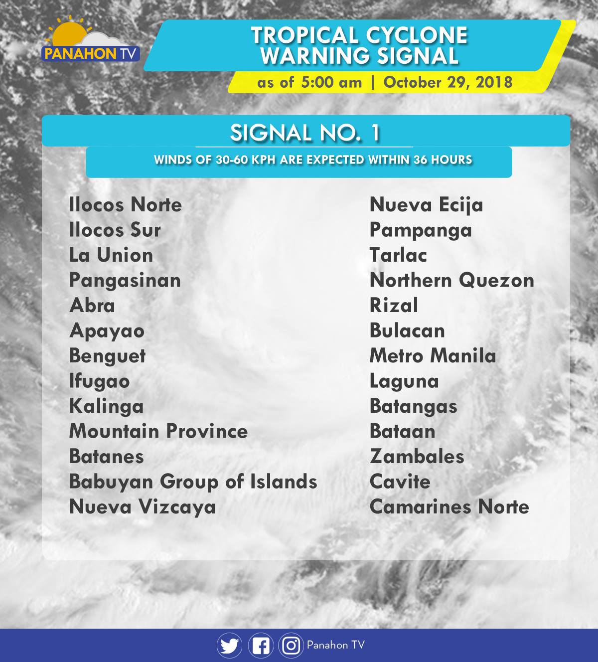
As Typhoon Rosita approaches the eastern section of Northern Luzon, Tropical Cyclone Warning Signals (TCWS) are raised by PAGASA in the following areas in preparation for incoming Typhoon.
In an Interview with PAGASA Weather Forecaster Ezra Bulquerin, he mentioned that the Typhoon may slightly weaken as it traverses the landmass of Northern Luzon. Although some parts of the country are already experiencing stormy weather, the Typhoon is expected to hit the landmass of Isabela-Cagayan later this evening. He also added that the Northeast Monsoon will not strengthen the Typhoon, but will only steer it toward Northern Luzon.
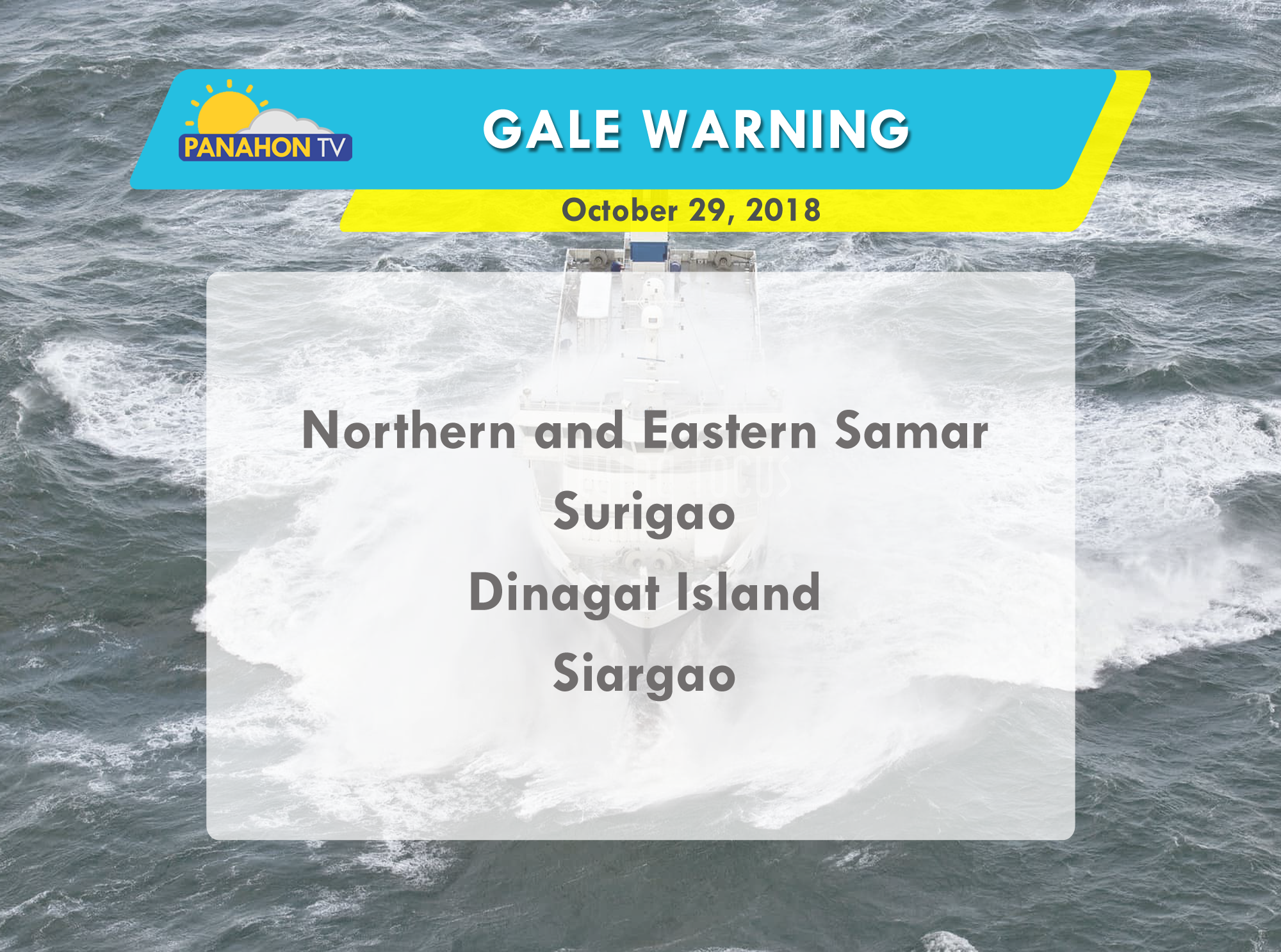
Due to strong waves brought by the Typhoon, gale warning is issued in the following areas:

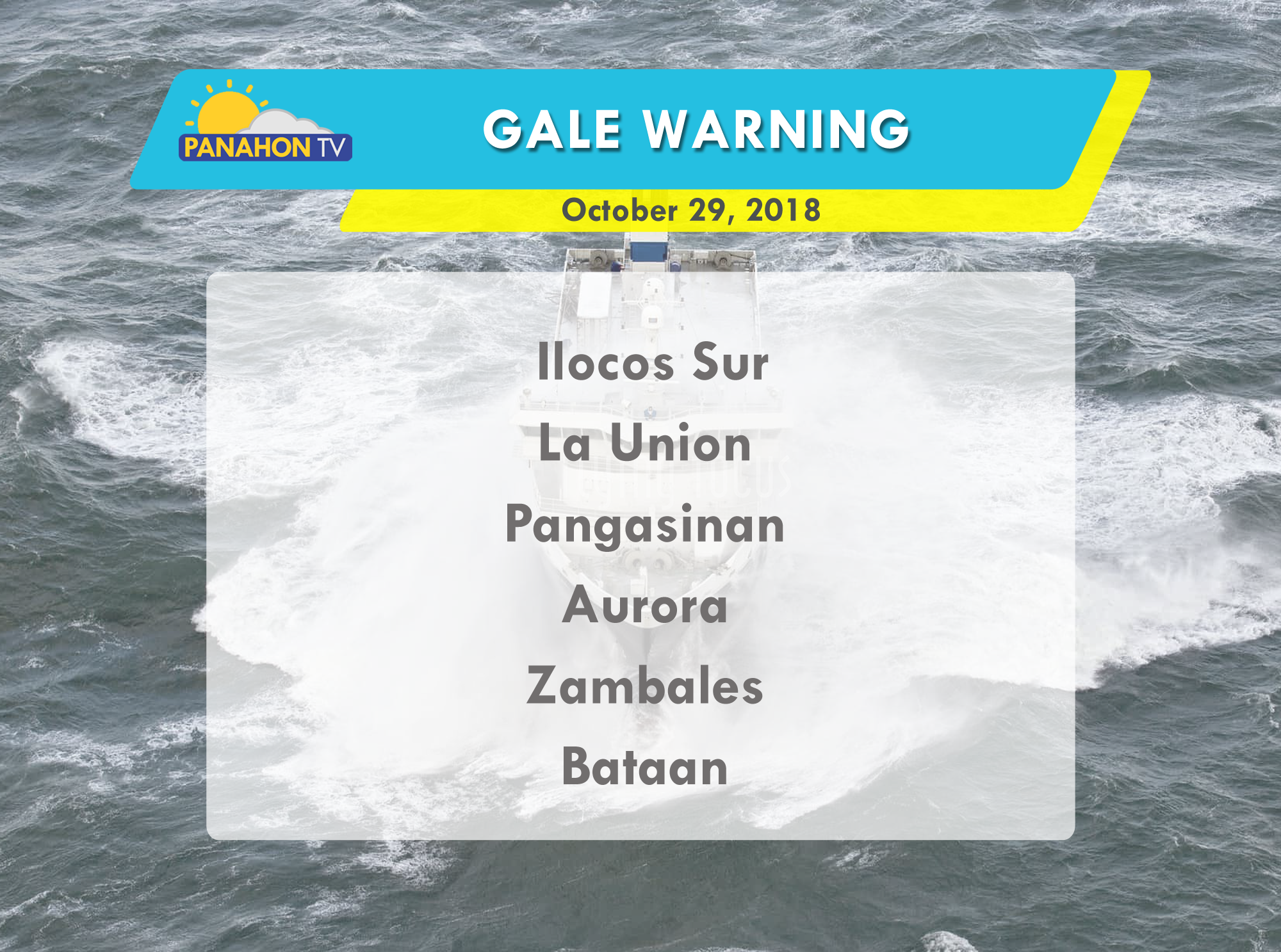

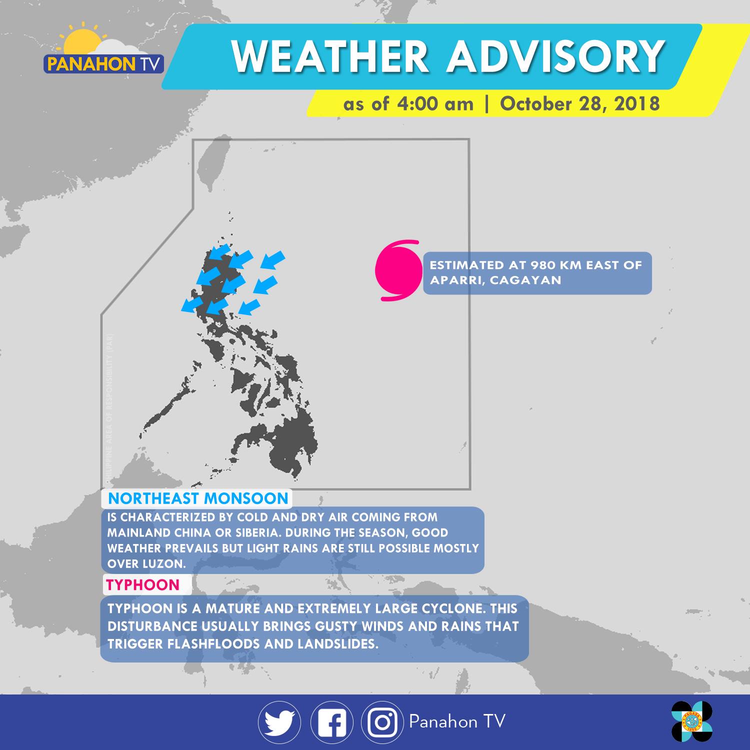
As of 4:00 a.m., Typhoon Rosita was last spotted 980 kilometers (km) east of Appari, Cagayan. With maximum sustained winds of 200 kilometers per hour (kph) and gustiness of up to 245 kph, it moves 20 kph westward. Meanwhile, the Northeast Monsoon or dry and cold winds coming from Siberia affects Northern and Central Luzon. It will bring cloudy skies with light rains in the Cagayan Administrative Region and Cagayan Valley. Meanwhile, partly cloudy to cloudy skies with isolated light rains are expected in Ilocos Region and Central Luzon. Metro Manila and the rest of the country will have partly cloudy to cloudy skies with isolated rain showers caused by localized thunderstorms.
According to PAGASA Weather Forecaster Meno Mendoza, Typhoon Rosita is expected to hit the landmass of Cagayan-Isabela by Wednesday afternoon. By Monday Tropical Cyclone Warning Signals (TCWS) are expected to be raised in Metro Manila and other parts of the country due to rains caused by the approaching Typhoon.

Due to strong waves brought by the Typhoon, gale warning is issued in the following areas.


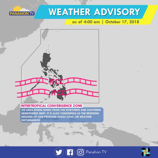
Intertropical Convergence Zone (ITCZ) affecting Mindanao which brings scattered rains and thunderstorms over ARMM, SOCCSKSARGEN and Zamboanga Peninsula. Meanwhile, Northeasterly Surface Wind Flow affecting Northern Luzon and causes light rains over the provinces of Cagayan, Batanes, Isabela and Apayao. Metro Manila and the rest of the country, fair weather condition prevails except for some isolated rain showers caused by the localized thunderstorms.
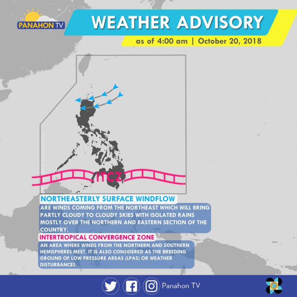
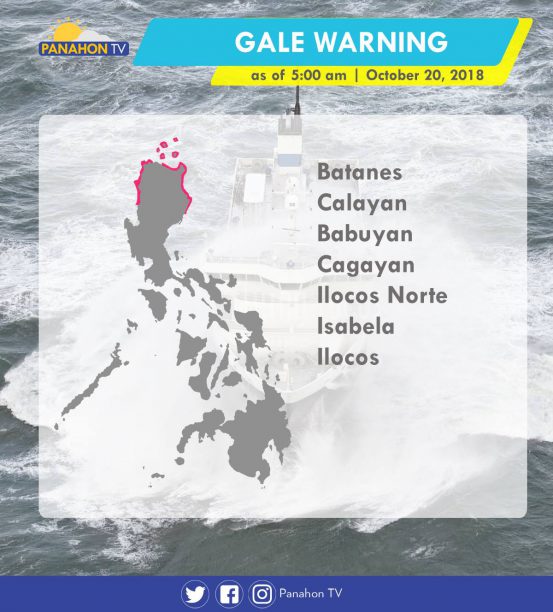
Gale warning is issued over the Northern Seaboard of Northern Luzon due to the strong gale force associated with the Northeasterly Surface Wind Flow.
The Intertropical Convergence Zone (ITCZ), the imaginary line where winds from the Northern and Southern hemispheres meet, brings cloudy skies with scattered rain showers and thunderstorms in Palawan, Visayas and Mindanao. Meanwhile, partly cloudy to cloudy skies with isolated rain showers will prevail in Metro Manila and the rest of the country.
According to PAGASA Weather Forecaster Gener Quitlong, two shallow Low-Pressure Areas were spotted east of Visayas and west of Palawan. But these will have no direct effect on the nearby landmasses and are expected to dissipate in the following days.
Although no Gale Warning was issued today, expect moderate to strong waves in the northern coastal areas due to winds brought by the Northeast Monsoon.