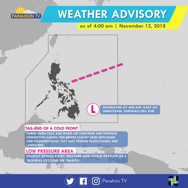
As of 3:00 a.m. today, aLow Pressure Area (LPA) was spotted at 405 km east of Hinatuan, Surigao del Sur. Due to the Trough of the LPA, Eastern Visayas and Mindanao will experience scattered rain showers and thunderstorms. Meanwhile, the Tail-end of a Cold Front affecting Southern Luzon will bring scattered rain showers and thunderstorms in the Bicol Region and Palawan. In Metro Manila and the rest of Luzon, the Northeast Monsoon prevails, bringing isolated light rains. The rest of Visayas will experience isolated rain showers caused by the localized thunderstorms.
According to PAGASA Weather Forecaster Ariel Rojas, the LPA is expected to hit the landmass of Mindanao tomorrow before exiting Sulu sea. As it crosses the ocean, the LPA is expected to develop into a Tropical Depression and will be named Samuel.
No gale warning is hoisted in any seaboards of the country.

The trough or extension of a new weather disturbance is affecting the country. Aside from this, Tail-end of a Cold Front and the Northeast Monsoon are also dominant.
In an interview with Panahon TV, PAGASA Weather Forecaster Meno Mendoza said that the Low Pressure Area (LPA) in Mindanao has dissipated but a new weather disturbance is being monitored outside PAR.
Due to the new LPA’s trough or extension, Visayas and Mindanao will have cloudy skies with scattered rain showers and thunderstorms will make flash floods and landslides possible. For Metro Manila, Central Luzon, CALABARZON, MIMAROPA, and Bicol Region, cloudy skies will be experienced with scattered rain showers and thunderstorms. Over Cagayan Valley Region, residents can expect cloudy skies with scattered rains. In Ilocos Region and Cordillera Administrative Region partly cloudy to cloudy skies can be enjoyed only with isolated rains.
Two weather systems will continue to bring lights rains to Northern and Central Luzon today.
According to PAGASA, the Northeast Monsoon or Amihan has intensified, bringing cloudy skies with light rains in Cordillera, Batanes, Babuyan, Cagayan and Isabela. In Eastern and Central Visayas, Bicol Region, Aurora and Quezon, cloudy skies with scattered rain showers and isolated thunderstorms will be experienced due to the Tail-End of a Cold Front. In Metro Manila, Ilocos Region and the rest of Central Luzon and Cagayan Valley, partly cloudy to cloudy skies will be experienced with light rains. In the remaining parts of the country, generally fair weather will be experienced only with isolated rain showers or thunderstorms.
Because of the surge of Amihan, gale warning is still in effect in the seaboards of Northern Luzon where wave height may reach up to 3.4 to 4.5 meters. Fishing boats and other small seacraft are advised not to venture out into the sea, while larger sea vessels are alerted against big waves in Batanes, Babuyan Group of Islands, Cagayan, the northern and western coasts of Ilocos Norte, the northern coast of Isabela, Ilocos Sur, La Union, Pangasinan, Aurora, and the eastern coast of Quezon including Polilio Island.
In an interview with PAGASA Weather Forecaster Mendoza, he said that the country is expected to remain storm-free in the next two to three days.
After a short break last week, the Northeast Monsoon is back and has further intensified.
Today, the Northeast Monsoon or Amihan brings cool breezes and rains in Northern and Central Luzon. Meanwhile, the Intertropical Convergence Zone (ITCZ) and Easterlies dampen Mindanao, and the eastern sections Southern Luzon and Visayas, respectively.
Today, Quezon, the Bicol Region, Eastern Visayas and Mindanao will have cloudy skies with scattered rain showers and thunderstorms. In Metro Manila, Ilocos Region, Cordillera, Cagayan Valley, and Central Luzon, partly cloudy to cloudy skies will be experienced with isolated light rains. In the rest of the country, partly cloudy to cloudy skies with isolated rain showers will prevail.
Gale warning is still raised in the northern seaboards of Northern Luzon. These include Batanes, Calayan, Babuyan, and the northern coasts of Cagayan and Ilocos Norte. Due to rough to very rough seas, fishing boats and other small seacraft are advised not to venture out while larger vessels are alerted against big waves.
Cooler Days Ahead
Temperatures continue to dip as the Northeast Monsoon, the cold and dry air from Siberia, intensifies. Yesterday, a chilling 16.6 degrees Celsius was recorded in Baguio City. In Tanay, Rizal 17 degrees Celsius was recorded, while the temperature dropped to 21 degrees Celsius in Infanta, Quezon. The surge of Amihan is expected in January and February.