Home > Blog > Weather
Top 3 Things You Need to Know about November Weather
Last October, we met Neneng, Ompong and Paeng but thankfully, none of these tropical cyclones hit Philippine landmass. The previous month also marked the onset of the northeast monsoon or amihan, bringing chillier early mornings.
Now that we have entered a new month, here are some important things to know about November weather:
1. The rainy season will continue.
Many have wondered if the official rainy season ended now that the amihan has started to affect the country. According to PAGASA Weather Forecaster Jori Loiz, the rainy season is almost over only in the western section including Zambales, Bataan and Metro Manila (areas under Climate Type I). These areas have received rains brought by the southwest monsoon or habagat that prevailed during the past few months.
Due to the northeast monsoon or amihan, rainfall this month will be concentrated mostly over the eastern section of the country. However, PAGASA Weather Forecaster Manny Mendoza said that most areas of Mindanao will also experience rainy weather brought by the Intertropical Convergence Zone.
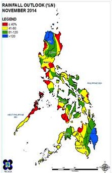
According to PAGASA, most areas in Luzon and Visayas will receive a generally below-normal rainfall while near-normal rainfall conditions will be experienced in Cagayan, Camarines Norte, Albay, Eastern and Central Visayas, and Mindanao.

2. Tropical cyclones will have a higher chance of hitting landmass.
An average of two or three tropical cyclones normally enter the Philippine Area of Responsibility (PAR) during the month of November. A higher chance of landfall is expected due to the effect of the amihan.
According to PAGASA Weather Forecaster Aldczar Aurelio, Visayas provinces are usually hit by tropical cyclones at this time because the amihan tends to drive the tropical cyclones towards the landmass.

3. Various weather systems will take center stage.
The dominant weather systems that will prevail within PAR are the Intertropical Convergence Zone (ITCZ), tail end of a cold front, amihan, possible low pressure area and tropical cyclones.
ITCZ is an area where air masses from the northern and southern hemispheres meet while the tail end of a cold front is the convergence of cold and warm air masses. Since converging winds result to cloudiness, both weather systems are expected to bring rain showers and thunderstorms over the affected areas.
Northeast Monsoon, on the other hand, is cold and dry air coming from the mainland China, responsible for the “malamig na simoy ng hangin” as the Christmas Season approaches.
Meanwhile, a possible formation of low pressure area could occur due to the active ITCZ. Once an LPA develops, it could intensify as a tropical cyclone or ”bagyo”.

Latest Advisories
