Home > Blog > Weather Today
Weather Today – August 4, 2015 | “Soudelor” to enter PAR on Wednesday
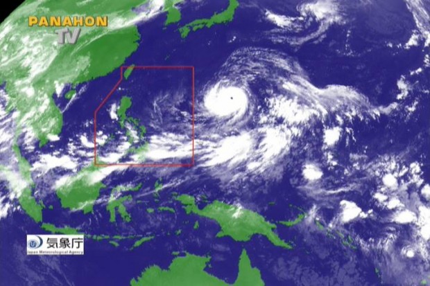

It seems like we are going to welcome the first week of August with rainy weather. “Soudelor” continues to intensify, now with maximum sustained winds of 210 kilometers per hour and gustiness of up to 245 kilometers per hour. PAGASA Weather Forecaster Glaiza Escullar says that as it traverses the ocean, it is likely to intensify and fall under super typhoon category due to the ocean heat and moisture content.
The eye of Soudelor was last spotted at approximately 1,995 kilometers east of Luzon. Moving in a west-northwest direction, it will possibly enter the Philippine Area of Responsibility (PAR) tomorrow, Wednesday. Once it enters the boundary, it will be given its local name, “Hanna”.
Escullar also mentioned that there is a slim chance for Soudelor (Hanna) to make a landfall. However, it can indirectly affect the Philippines by enhancing the southwest monsoon or “hanging habagat”. The surge of habagat could bring rains over some parts of the country. Meanwhile, she added that public storm warning signals will possibly be raised over extreme Northern Luzon as Soudelor heads towards Taiwan.
Today, the Intertropical Convergence Zone (ITCZ) prevails as the dominant weather system affecting Palawan and Mindanao. The entire Mindanao, Western and Central Visayas along with the province of Palawan will experience cloudy skies with light to moderate rains and isolated thunderstorms. Metro Manila and the rest of the archipelago will have generally fair weather aside from isolated thunderstorms.

Latest Advisories
