Home > Blog > Weather Today
Weather Today – September 23, 2018

As of 3:00 a.m., Severe Tropical Storm Trami was last spotted 1,580 kilometers east of Central Luzon (outside PAR). With maximum sustained winds of 100 kph (kilometers per hour) and gustiness of up to 120 kph, it moves west-northwest at 20 kph. Later this afternoon, it is expected to enter the Philippine Area of Responsibility (PAR).
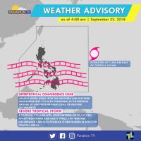
Meanwhile, the Intertropical Convergence Zone (ITCZ) still affects Southern Luzon, Visayas and Mindanao. It brings cloudy skies with scattered rain showers and thunderstorms in Visayas, Mindanao and Palawan. Meanwhile, partly cloudy to cloudy skies with isolated rain showers are expected in Metro Manila and the rest of Luzon.
According to PAGASA Weather Forecaster Meno Mendoza, the Severe Tropical Storm is expected to enter PAR later this afternoon, making it the country’s 16thTropical Cyclone of the year. Once this happens, it will be named Typhoon Paeng. If it remains its track, it will affect the northern and eastern sections of Northern Luzon.
No gale warning was issued today.
Patrick
Patrick Obsuna is an Astronomy graduate from Rizal Technological University. He did his internship in Panahon TV as a student correspondent reporting on Astronomy related segments and was later on hired as a reporter. He likes to promote Astronomy as a course to be studied and learned. He enjoys playing the violin in his free time.
Latest Advisories
