Home > Blog > Weather Today
Weather Today – September 25, 2018 #PAENGPH
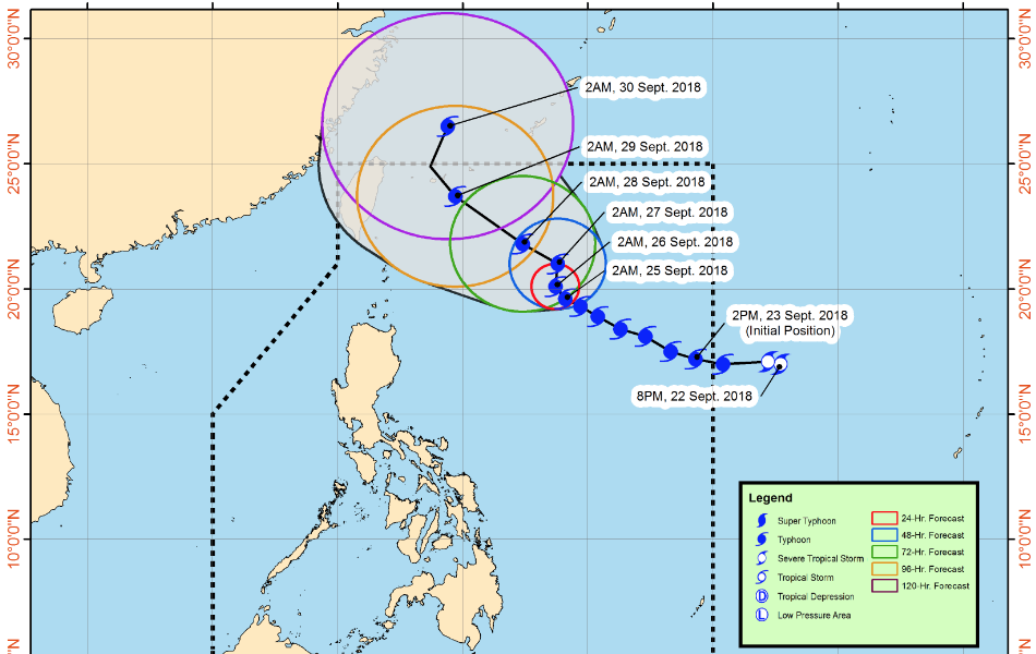
Northern Luzon should brace for rains induced by Typhoon Paeng.
At 3:00 a.m., the eye of the typhoon was spotted 740 kilometers east of Basco, Batanes. It has slightly intensified with maximum sustained winds of 200 kilometers per hour (kph), gustiness of up to 240 kph, moving west-northwest at 10 kph. According to PAGASA Weather Forecaster Ariel Rojas, light to moderate rains will prevail in Northern Luzon starting Friday. Tropical Cyclone Warning Signals may also be hoisted. The typhoon is expected to exit the Philippine Area of Responsibility on Saturday.
Today, the trough or extension of the typhoon will bring cloudy skies with scattered rain showers in Western Visayas, Zamboanga Peninsula, ARMM and Soccsksargen. Elsewhere, partly cloudy to cloudy skies prevail, but isolated rain showers are still possible due to localized thunderstorms.
PAGASA raised a gale warning off the northern seaboards of Northern Luzon and eastern seaboards of Luzon. Fisherfolk and those with small seacraft are advised not to venture out, while larger vessels are advised to take precautionary measures against rough to very rough sea conditions.
Latest Advisories
