Home > Blog > Weather Today
Weather Today – April 2, 2015 | #CHEDENGPH moving closer to Isabela-Aurora area
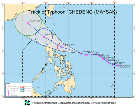
Typhoon “Chedeng” maintained its strength with maximum sustained winds of 130 kilometers per hour and gustiness of up to 160 kilometers per hour. At 8:00AM today, it was located at 500 km East Southeast of Casiguran, Aurora or at 265 km Northeast of Virac Radar, Bato, Catanduanes.
Moving west northwest at 19 kilometers per hour, Chedeng is expected to make landfall over the coast of Aurora-Isabela area tomorrow morning. It will then exit the landmass through Ilocos Sur by Sunday evening and will exit the Philippine Area of Responsibility (PAR) on Monday morning.

Public storm warning signal number 2 is up over Catanduanes where winds of up to 61-100 kilometers per hour in at least 24 hours. Meanwhile, Signal number 1 includes Camarines Sur, Camarines Norte, Quezon including Polillo Ilsand, Rizal, Bulacan, Pampanga, Tarlac, Nueva Ecija, Pangasinan, La Union, Ilocos Norte, Ilocos Sur, Abra, Apayao, Cagayan, Benguet, Kalinga, Aurora, Quirino, Nueva Vizcaya, Ifugao, Isabela and Mountain province. These areas will experience winds of up to 30-60 kilometers per hour in at least 36 hours.
Potential impacts of the winds:
PSWS #2
Moderate damage to agriculture
Rice and corn adversely affected
Few large trees uprooted
Large number of nipa and cogon houses partially or totally unroofed
Some old galvanized iron roofing may roll off.
Travel by all types of sea vessels and aircrafts is risky.
PSWS #1
Twigs and branches of trees may be broken .
Some banana trees may tilt or land flat on the ground.
Rice in flowering stage may suffer significant damage.
Some nipa and cogon houses may be partially unroofed.
Sea travel of small seacraft and fishing boats is risky.
PSWS serve as warnings and should not be taken as an indication of the present situation. Because preparedness is the key to any disaster, PAGASA provides these storm warning signals ahead of time.
Holy Week Weather: Black Saturday
According to PAGASA, stormy weather is expected over the regions of Cagayan Valley, Cordillera and the provinces of Aurora, Quezon and Catanduanes. Partly cloudy to cloudy skies with isolated rain showers or thunderstorms will prevail over Metro Manila and the rest of the country.
Fishing boats and other small sea craft are prohibited from sailing as gale warning is still up over the northern seaboard of Luzon and the eastern seaboard of Bicol Region and Visayas. These areas will experience wind force of 52 to 63 kilometers per hour and wave height ranging from 3.4 to 4.5 meters.
Meanwhile, another tropical cylone is now being monitored outside the PAR. However, PAGASA Weather Forecaster Samuel Duran said it is at approximately 2, 000 kilometers east of our boundary and is still too far to affect the country. As of now, our weather men are focusing on Chedeng as it moves closer to landmass but once the tropical depression outside the PAR shows development, PAGASA will also provide updates.

Latest Advisories
