Home > Blog > Weather Today
Weather Today – August 8, 2015 | #HANNAHPH weakens; another cyclone intensifies
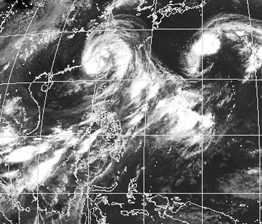

As Typhoon Hanna crosses Taiwan, it slightly weakens. Now, with maximum sustained winds of 150 kilometers per hour (kph) and gustiness of up to 185 kph, it is expected to move northwest at 20 kph.
Based on the latest data of PAGASA, Hanna was located at 415 kilometers north-northwest of Itbayat, Batanes. PAGASA Weather Forecaster Aldczar Aurelio says that if it maintains speed and direction, it is expected to leave the Philippine Area of Responsibility (PAR) this afternoon, between 3:00 to 5:00 PM. Once it exits our boundary, it will head towards the southern part of China.
Though Hanna gradually makes its path away from the country, storm signals are still up over the extreme Northern Luzon.

Areas under storm signals are still alerted against stormy weather brought by the typhoon. Meanwhile, Hanna continues to enhance the southwest monsoon or “habagat,” which will dump rains over Western Visayas, Mindoro, Ilocos Norte and Apayao. Cloudy skies with light to moderate rains and isolated thunderstorms are expected over Zamboanga Peninsula, Metro Manila and the rest of Luzon and Visayas. The rest of Mindanao will have a generally fair weather aside from possible isolated thunderstorms.
Due to habagat, sea conditions remain rough to very rough over the seaboards of Luzon, Panay Island, and Visayas and Mindanao. All fishing boats and other small seacraft are still prohibited to travel as wave height could reach 4.5 meters.
Aurelio says that in the coming days, the effect of habagat will be concentrated over Luzon, while areas in Visayas and Mindanao will experience improved weather conditions.
On the other hand, the tropical cyclone outside the Philippine Area of Responsibility (PAR) intensifies into a tropical storm, now being called “Molave.” According to Aurelio, it is expected to move north, thus, has a slim chance of entering our boundary.
This August, 2 to 4 tropical cyclones are expected to prevail in the PAR.
Latest Advisories
