Home > Blog > Weather Today
Weather Today – May 4, 2015 | Tropical Storm being monitored
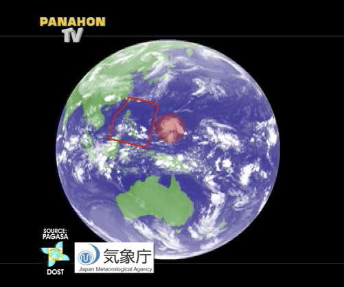

After monitoring the fight of the century, Filipinos must now monitor a tropical storm (TS) outside the Philippine Area of Responsibility (PAR). As of 4:00AM today, TS “Noul” was estimated at 1,555 kilometers east of Mindanao with maximum sustained winds of up to 65 kilometers per hour and gustiness of up to 80 kilometers per hour.
Moving in a west- northwest direction at 9 kilometers per hour, PAGASA Weather Forecaster Jori Loiz said it is expected to enter the PAR by Wednesday or Thursday. Once it enters the boundary, it will be given a local name “Dodong”.
To give us an overview on how tropical cyclones behave during the month of May, here are the possible scenarios based on the climatological records of PAGASA:

Scenario 1: A cyclone will move closer to landmass but will then recurve northward, moving farther away from the country.
Scenario 2: A cyclone will possibly make landfall before recurving northward as it moves away from the country.
Noul is still too far to directly affect any part of the country. However, easterlies remain dominant, affecting the eastern section of Luzon, Visayas and Mindanao. The whole archipelago will still experience partly cloudy to cloudy skies with isolated rain showers or thunderstorms.
As some parts of the country start to feel the warm weather, some areas experienced rains early this morning. PAGASA issued several thunderstorm and rainfall advisories as early as 4:44AM.
#VIS_PRSD 4:44AM, 04May’15 Light to moderate rains affecting #SouthernLeyte (Anahawan, Hinunangan, Hinundayan,… http://t.co/Qn13gXGXbx
— PAGASA-DOST (@dost_pagasa) May 3, 2015
#MIN_PRSD 5:15 AM, 04 May 2015 Light to moderate #rains affecting portions of #ZamboangaPeninsula,… http://t.co/KRGyIhpjnu
— PAGASA-DOST (@dost_pagasa) May 3, 2015
THUNDERSTORM ADVISORY NO.4 #VIS_PRSD Issued at 5:32AM, 04 May 2015 Thunderstorm is affecting #Cebu (Lapu-Lapu)… http://t.co/gjIKTAfyyY
— PAGASA-DOST (@dost_pagasa) May 3, 2015
Latest Advisories
