Just after midnight on August 17, 1976, a magnitude 8 earthquake shook the areas around Moro Gulf in Mindanao, including Cotabato City. But the disaster did not stop there; less than 5 minutes later, a tsunami as high as 9 meters roared and swallowed 700 kilometers of coastline. When the sea ebbed to its peaceful state, around 8,000 had died from the combined effects of the earthquake and tsunami, with the latter accounting for 85% of deaths and 95% of those missing and never found. The event, now known as the 1976 Moro Gulf Earthquake, is recognized as the deadliest earthquake that ever hit the country.
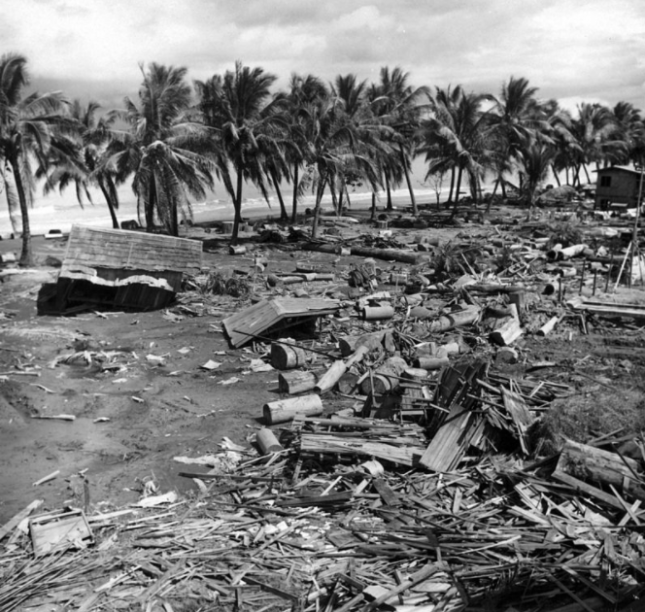 Devastation of the 1976 tsunami at Barangay Tibpuan in Lebak, Mindanao (Photo from Wikimedia Commons)
Almost two decades later on November 15, 1994, Mindoro was rocked by a magnitude 7.1 earthquake. Like what happened in Mindanao, majority of the 78 casualties of the Mindoro earthquake was due to the 8-meter high tsunami that occurred 5 minutes after the quake.
The truth is, though Filipinos are aware of devastating tsunami happening in other countries like Japan and Indonesia, they do not often associate these natural disasters in their homeland. But as past events indicate, deadly tsunami can occur locally. As Undersecretary of the Department of Science and Technology (DOST) for Disaster Risk Reduction-Climate Change Adaptation (DRR-CCA) and Officer-In-Charge of the Philippine Institute of Volcanology and Seismology (PHIVOLCS) put it, “Tsunami are very fast in the Philippines and we need to prepare for them.”
Tsunami 101
In observance of World Tsunami Awareness Day last November 5, PHIVOLCS organized an online press conference to spread the word about tsunami. Mostly generated by under-the-sea earthquakes, tsunami are characterized by a series of waves with heights of more than 5 meters. According to Solidum, such earthquakes can be triggered by underwater landslides, volcanic eruptions, and the more unlikely meteor impacts. These cause the seafloor to lift, causing the water it carries to rise.
There are two types of tsunami—the distant and local. Distant or far-field tsunami is generated outside the Philippines, mainly from countries bordering the Pacific Ocean like Chile, Alaska (U.S.) and Japan. With these events being monitored by The Pacific Tsunami Warning Center (PTWC), the Philippines has 1 to 24 hours of preparation before the tsunami’s arrival, depending on its origin.
But with local tsunami, lead time is cut down to a mere 2 to 10 minutes after the earthquake. “Preparedness is very important because rapid response is needed for locally-generated tsunami. The trenches are where the large earthquakes and tsunami can be generated, and we are only the country wherein trenches can be found on both sides. Hence, both sides of the country need to prepare for tsunami. Aside from that, the eastern side of the country faces the Pacific Ocean or the Pacific Ring of Fire where earthquakes and tsunami can also be generated,” said Solidum.
What PHIVOLCS is doing
Part of the Tsunami Risk Reduction Program of PHIVOLCS are the Tsunami Hazard Mapping and Modeling, and the Tsunami Hazard Risk Assessment, both of which aim to understand tsunami, manage their hazards and risks, and identify priority actions for response and recovery. To detect possible tsunami, PHIVOLCS set up its Monitoring and Detection Networks Development.
Aside from the 107 seismic stations that receive data for earthquakes and tsunami, there are also 29 real-time tide gauges all over the country. Through the hazards and risk-assessment software code REDAS, PHIVOLCS can evaluate potential earthquake hazards, create tsunami simulations, and predicting the number of affected people. “The total population exposed to tsunami would be close to 14 million,” said Solidum. “But they will not be affected at the same time. It would depend on where the tsunami would occur. In NCR, for example, the prone population would be around 2.4 million. And the next highest would be 1.6 million in Region VII, 1.2 million in Region VI— and in Region IXA, around 1 million.”
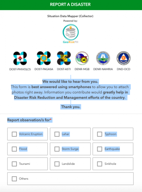
Meanwhile, HazardHunter Philippines, which is open for public use, can assess hazards depending on the user’s specific location. “HazardHunter can also give you a more detailed tsunami hazards assessment because it can provide you a map showing the different areas that will be affected by different tsunami heights. It is color coded, indicating areas prone to various tsunami heights.” Solidum appealed to the public to take advantage of the “Report a Disaster” website. Here, people can post pictures and videos of current risks and hazards in their areas, and describe disasters impacts, which can help the government’s risk and impact assessments.
 Screencap of “Report a Disaster” website
“In the Philippines, we use a simple tsunami information or warning scheme,” explained Solidum. “We will evacuate once the tsunami information is categorized as a tsunami warning. We expect a destructive tsunami of more than 1 meter and this would need immediate evacuation of coastal areas. Boats at sea are advised to say offshore — in deep waters.”
Shake, drop and roar
Because local tsunami can be very fast, people need to know its natural signs:
Shake – refers to a strong earthquake.
Drop – refers to the sea level receding fast.
Roar – refers to the unusual sound of the returning wave, which indicates a tsunami.
After an earthquake, Solidum recommends for people near the shore to immediately move to elevated ground inland, or take refuge in tall and strong buildings. “If they have not moved at all, once they hear the tsunami and there are unusual sounds, there might not be enough time. They really need to respond immediately,” warned Solidum.
PHIVOLCS also released tsunami safety and preparedness measures on their website:
- Do not stay in low-lying coastal areas after a felt earthquake. Move to higher grounds immediately.
2. If unusual sea conditions like rapid lowering of sea level are observed, immediately move toward high grounds.
3. Never go down the beach to watch for a tsunami. When you see the wave, you are too close to escape it.
4. During the retreat of sea level, interesting sights are often revealed. Fishes may be stranded on dry land thereby attracting people to collect them. Also sandbars and coral flats may be exposed. These scenes tempt people to flock to the shoreline thereby increasing the number of people at risk.
Solidum stressed the importance of community-based preparedness, built on planning and drills to create the following output:
- development of evacuation plans based on the hazard maps
- installation of different types of signage (signage for hazards, signage for the evacuation area, signage for the directions to go to the evacuation area)
- conducting of seminars and lectures
- drills
Tsunami preparedness during COVID-19
The devastation of several typhoons this year, coupled with the country’s location in the Pacific Ring of Fire, are proof that the Philippines is prone to various hazards. Because of the
COVID-19 pandemic, Solidum admitted that PHIVOLCS had to rethink their training methods. “Before, we actually go down to various coastal communities and conduct lectures in the evening, so that people who worked in the daytime can also attend. But the pandemic has enabled more people to listen because of the social media platform and our webinars. We’ve reached more people in terms of information campaign. But we hope that local government disaster managers will do the actual preparedness at the community level.”
Solidum noted that though COVID-19 continues to cause loss of lives and the disruption of public services, mobility and economic development, tsunami can create far more devastating impacts. “We will see the physical impacts through buildings, infrastructures, property, water supply pipes, electrical supply, communication system, roads, bridges, and ports. This is in addition to the physical impact on people because of the collapsing houses or the impact of the large volume of water. We have science, technology, and innovation from DOST that can help in preparedness and disaster risk reduction. We need to use it, but we need to share this information to the communities and the public,” he ended.
Watch the full press conference from PHIVOLCS.
Watch Panahon TV’s primer on tsunami.
Agay Llanera
An hour before midnight on October 26, 1978, Super Typhoon Kading was at its peak in the country, bringing torrential rains that caused the water level at Angat Dam to swell. Because stored water, when reaching a critical high level, might cause dam structures to break, the National Power Corporation (NPC) opened all its three floodgates to 8 meters. As the rains continued to pound, adding to the dam’s water level, NPC decided to further open the floodgates to its maximum height of 14 meters by 6 a.m. the next day.
This result was a catastrophe. With the sudden dam release, several towns in Bulacan near Angat Dam was instantly flooded. But the damage in houses, farms and working animals amounting to millions of pesos was not the only tragedy; with the dam’s spillways being opened without prior warning while residents were asleep, almost 200 people died in the sudden floods.
Civil suits were filed against NPC. Complainants all attested that they had not been warned of the maximum water release. Lives could have been saved if the dam release operation was done earlier and more gradually, and if there were proper communication among the sectors involved. In 1993, the suit was won, and NPC settled by giving 5 million pesos to families of those who had died.
But the tragedy was a wake-up a call to the government, which recognized the protocol gaps in dam release. In 1983, it began the Flood Forecasting and Warning System for Dam Operation. Implementation began in 1990, while the system became fully operational in 1992. The project led to the establishment of the PAGASA Data Information Center, flood forecasting and warning systems in both PAGASA and dam offices, hydrological stations, warning posts, and repeater and monitoring stations.
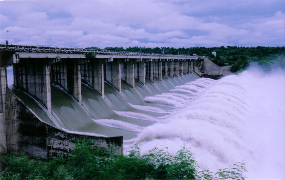
MARIS Dam in Nueva Ecija releases water (photo courtesy of NIA-Magat River Integrated Irrigation System)
Giving a dam(n)
PAGASA aims to manage the flooding risk caused by dams with its daily-updated products and services:
- Basin Daily Hydrological Forecast
- Flood bulletins
- General Flood Advisories (GFA) – Regional
- Status of Monitored Dams
Rosalie Pagulayan, a hydrologist at PAGASA, emphasizes the importance of risk management in harnessing the full potential of our dams. “Major dams are multipurpose,” she says. “They generate power, irrigate farms, provide potable water and controls flooding. During the rainy season, the dam stores excess water, keeping it from inundating the rivers and communities.” Angat Dam, in particular, provides 97% of Metro Manila’s water requirements, and irrigates 31,000 hectares of farmlands in Pampanga and Bulacan.
Though dams are meant to prevent flooding, extreme weather events that bring massive rains can force dam operators to conduct water releases.
But even the frequency of tropical cyclones in our country is a double-edged sword. “Many complain about the inconvenience of the rainy season, but upon studying our climate, a former PAGASA director was able to determine that 50% of our rain comes from tropical cyclones. If we don’t have tropical cyclones, our water supply suffers. Other weather systems are also important; the northwest and southwest monsoons bring 38% of our rain, while the ICTZ [intertropical convergence zone] brings 12%.” She adds that rains are important in crop irrigation and pushing out atmospheric pollution.
Pagulayan, who has been working in PAGASA for 15 years, says that there are protocols before spillways are opened. “Even before a typhoon comes, we predict how much rainfall it will bring. We give the data to the different dam offices, which compute the expected increase in water levels. To accommodate the incoming rain, the dams conduct pre-release—but only according to the river’s capacity to prevent flooding.” She adds that aside from measuring the amount of rain in the watershed, PAGASA also measure the rain’s impact. “There’s a warning post from dam offices before they release water. There’s ample lead time, so for example, if they’re opening the gates at 4 p.m., they warn residents as early as 10 a.m. so they can prepare.”
How flooding risks can be better managed
In other parts of the world, river systems span countries, such as the Brahmaputra River, which comes from India but flows downstream to Bangladesh. The famous Danube River also comes from several European regions. Such a situation calls for strong international coordination when the source of the river swells, and flows down to various countries and territories in low-lying areas.
But Pagulayan says this is not a problem in our country. “We are blessed with big river systems. We manage our own rivers, and solely benefit from them. Our rivers traverse through various municipalities, provinces and even regions.”
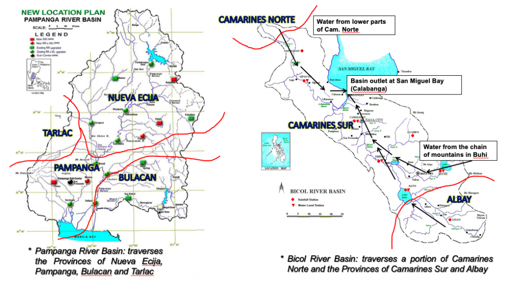
In the left graph above, Pagulayan shows how water from Nueva Ecija flows down to the Pampanga river basin, and contributes to a portion of Tarlac and Bulacan. “Our river systems encompass a lot of areas so disaster managers in these zones should be seamless in their communication and info-sharing.”
Meanwhile, as shown in the right graph above, water from the Bicol river basin comes from Albay, Camarines Norte, and mostly Camarines Sur. “But the Camarines Norte source is very important because rains are strong there, and because of its elevation, water flows down very fast,” shares Pagulayan. “All these rivers are owned by the Philippines. We don’t share them with other countries or regions. We are the only ones who can harness their potential.”
In areas that receive a lot of rain, dams and water reservoirs are built in mountainous areas, which can hold excess water. But watershed deforestation is an issue, leading to its decreased capacity for water storage. This may lead to flooding during the rainy season, and water supply shortage during the hot and dry season.
Risks also increase when people build their homes and livelihoods near waterways and flood plains. “They may find it convenient to set up livelihoods that require water, such as farms, in those areas, but once water is released, their safety is compromised,” explains Pagulayan. “Flooding also negates development efforts, and destroys agricultural products and infrastructure. But the worst risk of all is the loss of lives.”
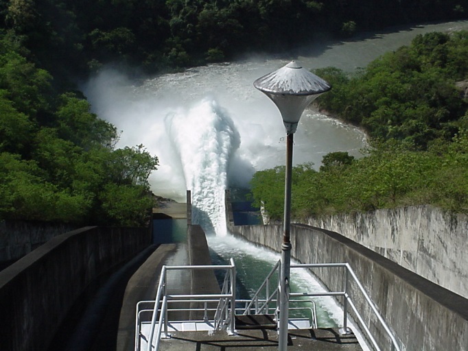
MARIS Dam’s spillway in Nueva Ecija (photo courtesy of NIA-Magat River Integrated Irrigation System)
Moving forward
To foster good relations with dam offices and local government units (LGU), PAGASA regularly conducts information and education campaigns, public information drives, and communication drills. “For every disaster, the challenge, I think, is communication, so this is what we constantly develop. We can’t stop; it has to be continuous so we can improve,” Pagulayan shares.
By practicing and strengthening the information flow from PAGASA down to the regional and municipal levels, data accuracy is ensured, allowing LGUs to map out action plans to lessen flooding impacts. “We learn from every experience how to convey data and information. We are open to change and we adjust our activities, so we can improve both our services and community action,” ends Pagulayan.
Communities can also mitigate risks by knowing what to do before a tropical cyclone arrives and causes flooding.

Mindanao will experience rainy weather due to the prevailing intertropical convergence zone (ITCZ). Light to moderate rain showers are expected over Davao Region, CARAGA and Northern Mindanao. The remaining parts of the country may expect possible thunderstorm formation today.

As the metropolis gears up for the largest earthquake drill to be held in the National Capital Region today, PAGASA forecasts partly cloudy to cloudy skies with isolated thunderstorms in the following hours.
In order to make citizens aware of what to do when a magnitude 7.2 earthquake in Metro Manila occurs, as a result West Valley Fault’s movement, Panahon TV released tips and guidelines.
Know more here:


The Metropolitan Manila Development Authority is in need of 8,000 volunteers for the Metro Manila Rescue Volunteers Corps to be deployed in case of earthquake. The group’s primary commitment is to serve as additional manpower to the existing 6,000 MMDA rescuers.
Eligible volunteers must be 18 years old and above and willing to undergo a three-day earthquake response and rescue training facilitated by the MMDA. Volunteers must be physically fit to fulfill search and rescue duties if and when the West Valley Fault moves. Volunteers will be grouped according to expertise and will be coached by batch of 30s.

Students whose families live in provinces that will not be affected by The Big One and those who live in the University Belt are encouraged to join the corps.
Aspirants will be screened by MMDA upon filling out the form at www.bepreparedmetromanila.com/ .
The Philippines lies in the Pacific Ring of Fire where the most number of volcanic and seismic activities are recorded. Provinces at risk to earthquakes include Surigao Del Sur, La Union, Benguet, Pangasinan, Pampanga, Tarlac, Ifugao, Davao Oriental, Nueva Vizcaya and Nueva Ecija. But the Greater Metro Manila Area (GMMA) is no exemption to tremors due to the Valley Fault System that may generate a quake with a magnitude of 7.2 –as powerful as 63 Hiroshima atomic bombs. To prevent casualties and damage to properties, here is what we need to know.
Being Quake Ready
1. Check your house for hazards for earthquakes and other secondary threats such as landslides, flooding, liquefaction and fires. If your house is erected within the 5-meter buffer zone from each side of the fault line, it is best to transfer to a safer place.
2. Make sure that your house is structurally sound.
3. Assemble your own Bug Out Bag.
4. Have a printed copy of the emergency hotlines.
5. Participate in office, school and community drills.
6. Hold occasional drills at home with the entire family.
7. Cascade emergency plans to your family. It is important to decide how, where and when to meet after an earthquake.
8. Turn off water, electricity and gas when not in use.
9. Know how to give first aid and Cardio Pulmonary Resuscitation (CPR).
Protecting Yourself During a Quake
1. Stay calm but be alert and keep your eyes open.
2. When inside a structure, do the Duck, Cover and Hold.
3. If no sturdy table is around, go against an interior foundation wall and cover your head with your arms. Remember to move away from objects that may fall, break, explode and cause electrocution.
4. If inside a movie house or a stadium, stay in your seat and cover your head with your arms.
5. When in a crowded building, do not rush for exits and stay away from falling debris.
6. When in a wheelchair, stay in it, lock your wheels and protect your head.
7. If you’re outdoors, move to an area away from posts, trees, buildings, electrical wires and poles.
8. When driving, move to the side of the road and stop.
9. If near the shore, go to higher grounds with your bug out bag.

After the Quake
1. If inside a structure, safely and calmly exit to avoid stampede. Use the stairs instead of elevators. Proceed to areas clear of falling and collapsing objects.
2. Do a headcount of your family and check for injuries. If someone has serious injuries, do not attempt to move him and call for medical assistance.
3. If trapped inside a building, wave a handkerchief or any cloth in the window to signal rescue. If you have whistles, use it. If there is no any window, stay in a safe area and do not touch any damaged appliance.
4. If outdoors, do not cross bridges, flyovers and tunnels. Do not enter damaged buildings.
5. When inside a car, park in the nearest place clear of falling debris and tall structures.
6. If it’s already safe, check for fire hazards, damaged utilities, wired telephone lines, and structural aspects in your house. If damages occur, evacuate and do not re-enter until proper repairs are done.
7. Wear gloves, facemask, boots or shoes when cleaning leakages. Stay away from fallen power lines and the possible conductors near them.
Do not walk in barefoot while checking the house.
8. Be prepared for aftershocks by knowing where to duck, cover and hold. Aftershocks may happen hours, days, weeks and even months after the main shock.
9. Get involved in community post-disaster plans and projects.
Because we live in an archipelago often frequented by cyclones and quakes, preparedness should be part of our lifestyle. That’s why it’s wise to devote a few hours of assembling Bug Out Bags with the family on a laidback weekend.
A Bug Out Bag (BOB) is a handy survival kit that contains our necessities in times of emergency. It is also called Go Bag, Grab Bag or Bailout Bag. This usually consists of supplies that will help you survive the first three days when trapped in a building or moved to an evacuation site, especially when problems occur during rescue and relief operations.

Water and Food Supply
Our body and vital organs need hydration to transport nutrients and eliminate waste. Over 72 hours with no water intake may lead to death. Each member of the family should have at least 3 liters of water in their BOB.
When choosing BOB food, go for the non-perishable, lightweight, less salty and ready-to-eat food items. Having a detailed supply list, including their expiration dates, will be helpful as you quarterly check the contents of your BOB.
Important items also include a can opener, Swiss knife, tumbler, plastic container and enough number of sporks.
First Aid and Hygiene
A First Aid Kit is helpful in dealing with minor injuries and illnesses. This should have the following:
- plasters in different sizes and shapes
- sterile gauze dressings
- triangular bandages
- safety pins
- disposable gloves
- tweezers
- scissors
- cleansing wipes
- thermometer
- antiseptic cream
- Povidone iodine
- painkillers
- aspirin
- Ibuprofen
- cough medicines
- antihistamine
- eye wash
- insect repellant
- thermal blanket
It’s best to create a list indicating the product’s use, expiry date, and other necessary instructions. Practicing how to use the bandages and other medical tools is also advisable.
Wet wipes, toilet paper, hand sanitizer, toothpaste and toothbrush, hypoallergenic soap, towels and other bathing needs should be put in a separate pouch.
Clothing
The choice of clothing should be based on the current season.
The basic set of clothing includes long sleeves, pants, shorts, socks, underwear, shirts, handkerchiefs and raincoats. Remember to pack clothes that will suffice for 3 days. Remember to put the clothes in a plastic bag first before packing it in your BOBs.
Other Contents
Other important things to put inside your BOB are flashlights with extra batteries, power bank, whistle, sleeping bag, rope, plastic bags and extra money.
After preparing your BOB, place it in an accessible, cool and dry place at home. You may also put one in the trunk of the car, in your office or school. Reiterate to the entire family that BOBs should only be used during emergency.

In preparation for the possible movement of the Valley Fault System that may jolt the Greater Metro Manila Area (GMMA) within this lifetime, the Metropolitan Manila Development Authority (MMDA) has identified evacuation camps and centers across the metropolis.
Metro Manila is divided into four quadrants for better evacuation and rescue operations among residents. Operation centers and staging areas that will serve as evacuation camps are also pointed out in the contingency plan of MMDA.

Athletic fields, memorial parks, sports arenas, churches and gymnasiums of Local Government Units (LGU’s) will also be used as evacuation centers in the Metro Manila and nearby cities and provinces. Pasig River will also serve as an alternate route for rescue and relief personnel in the event that bridges in the capital city are destroyed by the huge quake.
The earthquake, projected in having a 7.2 magnitude may collapse 500,000 houses and damage over 300 buildings. According to studies done by PHIVOLCS and other agencies, the West Valley Fault’s 100-kilometer length traverses through Rizal, Marikina, Quezon City, Pasig, Makati, Taguig, Muntinlupa and Laguna. Moreover, 35% of the population inhabiting the said areas lives right above this fault line.
Though predictions are alarming, they do not aim to cause panic. The warnings are meant to properly prepare the public in case the earthquake occurs. Though no machine can predict when this hazard will strike, in this lifetime or in the next, it’s still best to be ready than not, because the human cost of this quake is far too heavy to ignore.

On May 18, 2015, the Philippine Institute of Volcanology and Seismology (PHIVOLCS) launched Atlas, the detailed map of the active faults traversing the Greater Metro Manila Area (GMMA) and nearby provinces. This handbook with 33 map sheets was also distributed to city planners and local government officials from cities and towns crossed by the Valley Fault System (VFS) to help them draft more comprehensive emergency plans and proper zoning ordinances.
VFS includes the West and the East Valley Faults. The West Valley Fault is approximately 100 kilometers long and can generate a 7.2 magnitude quake in densely populated cities. This is as catastrophic as the quakes that shook Nepal just a month ago and Bohol in 2013.
The West Valley Fault spans from Bulacan to Cavite. According to studies, it moved four times in the last 1,400 years with an interval of 200 to 400 years. Its last recorded earthquake was in 1658 or 357 years ago, making its next movement possible in this lifetime. And if this happens, over 34,000 people may perish, 100,000 people may be injured, and an additional 18,000 lives will be at risk due to fire incidents. With a projection of P2.3 trillion cost of damage, it is indeed the greatest threat that can paralyze not only our capital city, but also the entire nation.

AREAS TRAVERSED BY THE WEST VALLEY FAULT:
• Bulacan (Doña Remedios, Trinidad, Norzagaray, San Jose del Monte)
• Rodriguez, Rizal
• Marikina
• Quezon City
• Pasig
• Taguig
• Makati
• Muntinlupa
• Laguna (San Pedro, Biñan, Sta. Rosa, Cabuyao, Calamba)
• Cavite (Carmona, General Mariano Alvarez, Silang)
Meanwhile, the East Valley Fault, which transects the municipalities of Rodriguez and San Mateo in Rizal Province, can generate a jolting 6.2 quake.
Metro Manila was divided into 22 scale maps and uses 1:5,000. On the other hand, Laguna and Cavite with 10 map sheets use 1:10,000, while Bulacan with one map sheet uses 1:50,000. These maps pinpoint the location of active faults, fissures, and the overlapping of both, whether or not they are covered by man-made or natural obstructions.
The atlas can be viewed and downloaded from the official website of PHIVOLCS.
Watch the video below to know how we can prepare for major quakes:
Sendai, Japan – After marathon meetings and negotiations at the 3rd United Nations World Conference on Disaster Risk Reduction (DRR), the HFA 2.0 or Hyogo Framework of Action for 2015-2030 was released on March 18, 2015. This is the revised document from the initial HFA that proposed DRR methods on a global scale, originally drafted in 2005.
The 5-day conference, held once every decade, was attended by world leaders from multi-sectors such as governments, non-government organizations, media, women’s groups, people with disabilities, private sectors, children and youth.
The HFA 2.0 addresses 4 priorities:
Priority 1: Understanding disaster risk
Priority 2: Strengthening disaster risk governance to manage disaster risk
Priority 3: Investing in disaster risk reduction for resilience
Priority 4: Enhancing disaster preparedness for effective response, and to “Build Back Better” in recovery, rehabilitation and reconstruction
The HFA has 7 global targets :
1. a substantial reduction in global disaster mortality
2. a substantial reduction in numbers of affected people
3. a reduction in economic losses in relation to global GDP
4. substantial reduction in disaster damage to critical infrastructure and disruption of basic services, including health and education facilities
5. an increase in the number of countries with national and local disaster risk reduction strategies by 2020
6. enhanced international cooperation
7. increased access to multi-hazard early warning systems and disaster risk information and assessments.
Building Resilience
This framework comes four years after the Great East Asia Earthquake in Japan. As one of the hardest hit areas of the tragedy that claimed 20,000 lives, the city of Sendai has shown the world their resilience through recovery efforts. Proof of this is their successful hosting of the conference with over 10,000 attendees.
However, in areas where the tsunami occurred, it would still take years for their complete rehabilitation. With soil drenched by salt water from the sea, agriculture in these areas was not possible at the moment.

Current recovery efforts included building better roads, elevating them by three meters as protection against tsunami.
Affected communities were relocated by their original clusters, which allowed residents to still live in close proximity with neighbors after transferring to safer areas.
Philippine contingents contribute to HFA
With the Philippines being of one the most disaster-prone countries, Filipino representatives at the conference significantly contributed to the drafting of the HFA 2.0.
Their input comprised of the following:
Inclusion of the elderly in policy making. Aside from the fact that the elderly have had years of experience on disasters, their participation will also allow the framework to develop DRR methods that consider their welfare.
Inclusion of the indigenous people. With traditional knowledge built by years of living in close contact with nature, the indigenous sector is a valuable contributor to the development of climate adaptation and disaster resiliency.
Highlighting the role of migrants. Migrants will also assist communities and societies in the structural design and implementation of DRR efforts.
Utilizing the sectors of the academe, science and research. These entities shall be focusing on disaster risk factors and scenarios, as well as emerging hazard risks in medium and long-term periods, in both regional and national levels—a wealth of information that can aid policy-makers.
Linkage with business, professional associations and private sectors. Doing so will be able to sustain DRR efforts. These sectors shall be integrating DRR in their business models to promote resiliency and continuous sustainable development of communities.
The Department of Science and Technology (DOST) also shared their multi-hazard tool called Project NOAH (Nationwide Operational Assessment of Hazards), which highlights maps that identify areas prone to floods and storm surges. Dr. Mahar Lagmay introduced WebSafe, a newly developed tool that provides visualization of the possible extent of a disaster and its impact to the people.
A national framework on Comprehensive School Safety, which incorporated disaster management in the school curriculum, was discussed by Education Assistant Secretary Laguda. The framework includes activities related to the arts, music and play, which students can share with family members.
Climate Change Commissioner Lucille Sering explained the importance of the Eco-town framework being done in the Philippines. This is a local implementation mechanism of the National Climate Change Action Plan (NCCAP) that gives direction to sustainable economic growth from 2011 to 2028. Through Eco-town, municipalities in areas most vulnerable to climate risks are given methods on mitigation and prevention.
Social Welfare and Development Secretary Dinky Soliman, who led the Philippine delegation, said in an exclusive interview with Panahon TV, “Napakahalaga ng conference na ito dahil nangyayari lamang ito every ten years. Yung mapagkakayarian, magiging batayan ng kilos, pagtulong at pakikipagtrabaho para babaan ang risko,” (This conference is really important because it only happens every ten years. And what will be agreed on this will be our new guidelines in implementing the revised framework for reducing risks.)
Children and Youth
As the HFA 2.0 paved the way on how countries could unite in addressing DRR, the children and youth sector also actively participated in the conference through the Children and Youth Forum, where they presented practical and innovative solutions for DRR.
Conference Highlights
During the conference, Cyclone Pam with category-5 strength, devastated the Pacific Island nation, Vanuatu. President Baldwin Lonsdale appealed to the international community for support.
With over a hundred forums in the famed “City of Trees,” the conference also included the private sector, whose resources and expertise were considered crucial to DRR.
Meteorological organizations, headed by the World Meteorological Organization, presented global figures on weather and climate, as well as new policies and technologies. Meanwhile, various sectors also introduced new applications of technologies in the fields of communication, automotive, construction, and health in exhibitions and at the BOSAI Fair.

 Media waiting for HFA 2.0
With reports from Donna Lina-Flavier and George Gamayo
Photos by Garrie David