Storm surges only entered the majority’s consciousness when Typhoon Yolanda devastated most of the Visayas, bringing 7-meter-high surges that claimed over 6,000 lives in Leyte and Samar in November 2013. The point cannot be emphasized enough: Storm surges can be fatal and we need to be prepared for them. Here’s a primer on one of the typhoon’s deadliest effects.
Top 5 Things You Need to Know about Storm Surges
1. A storm surge is not a tsunami. While a tsunami is a series of waves due to underwater seismic activities like earthquakes, a storm surge is the abnormal rise of seawater due to the low atmospheric pressure and strong winds brought about by a severe storm or typhoon. It may inundate low-lying coastal areas, resulting damage to properties, infrastructure and agriculture.
2. Storm surges can get pretty high. According to PAGASA, storm surges in our country may rise from an average of four to seven meters, which is equivalent to a 2-storey house, and may still intensify in the presence of high tide. Storm waves move as fast as seven meters per second, as fast as a golf ball driven off the tee, carrying small and large debris, which make them even more dangerous. When storm waves finally reach the ground, its speed becomes a little slower due to trees and other land structures.
3. Storm surges are deadlier in some areas than others. Studies say that storm surges may transpire in any seaboard affected by a severe storm, but the most devastating ones usually occur in our country’s southern and eastern seaboards. Eastern sections are typically flat and typhoon-frequented, making them prone to the surges.
4. Storm surges reoccur, especially in an archipelagic country like the Philippines. Eastern Visayas has been experiencing catastrophic storm surges for over a hundred years. On October 12, 1897 An Australian newspaper reported about a storm passing over Tacloban, the capital city of Leyte, claiming 7,000 lives. According to the Department of Science and Technology (DOST), the 1897 storm surge reached up to 7 meters, destroying churches and communities. In 1912, the front page of an American broadsheet featured a typhoon that injured and killed 15,000 people in Tacloban and Capiz. The DOST approximated the surge at four to nine meters tall.
5. More and more Filipinos face the risk of storm surges. The World Bank estimates more than 60% of our population live in coastal zones. In fact, the United Nations emphasized the swelling population of people residing in cyclone prone areas from 71.8 million in 1970 to 120.7 million in 2012. According to the National Geographic, the poor populace of the country has gradually moved to coastal islands, making a lot more people prone to the surges.
Now we know what storm surges are, how can we protect ourselves from them?
PREVENTIVE MEASURES AND SAFETY TIPS
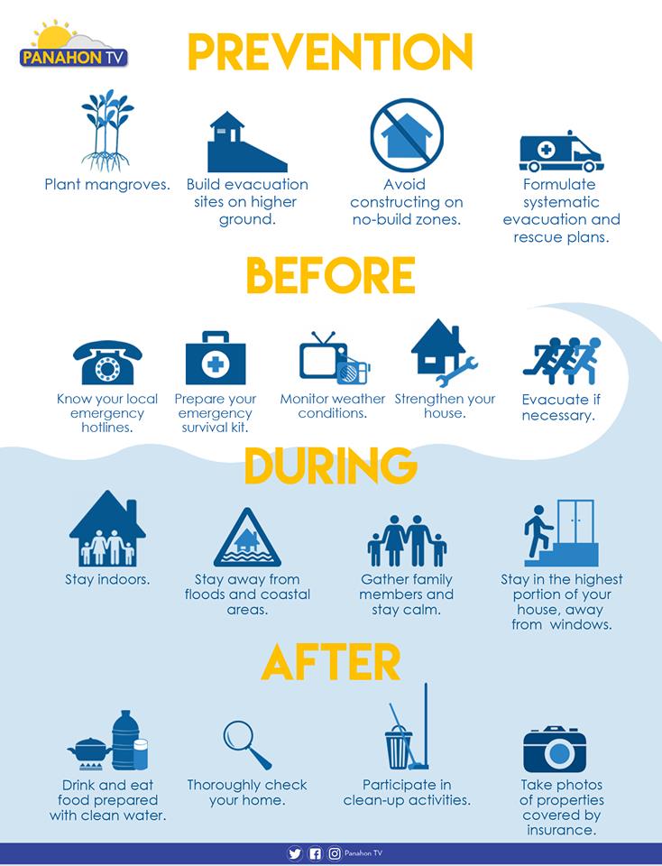
Plant trees. Plant mangroves and coconut trees along the shorelines, which may help shield the community from the waves brought by storm surges.
Avoid constructing on no-build zones. Know where the safe zones are by getting a hazard map from your barangay officers. A 40-kilometer buffer zone from the shore is advised in storm-surge prone areas.
Participate in community drills. Formulate systematic emergency, rehabilitation and relief distribution plans in your community. It is also essential to conduct a quarterly drill involving the children, youth, people with disability and senior citizens.
Plan with your family. Prepare a survival kit and a list of emergency hotlines. Discuss possible evacuation plans with your family and strengthen or fix your house if necessary.
Build evacuation sites on higher ground. Make sure that all evacuation areas are materially safe. Ensure safe routes and build directional signages going to the location.
Monitor weather conditions. Always be updated on news and announcements via radio, television and social media.
Stay Indoors. Stay in the highest portion of the house or building, away from the windows.
Evacuate if advised. Evacuate before the surge transpires, but if some members of the family have not yet arrived, call them or leave a note to inform them of your location. Switch off electricity, the waterline and gas tank. Make sure that all windows, cabinets, doors and gates are closed and locked before leaving.
Stay away from flooded areas and shorelines. Never attempt to pass a swollen river and avoid routes along the sea.
Follow the rules in evacuation sites. Do not litter, vandalize or destroy anything in the area. Observe proper hygiene to avoid illnesses and maintain peace and order in your area.
Here’s what else you need to do in the wake of a storm.
Sources: PAGASA-DOST, PROJECT DINA & Project NOAH
The second half of 2013 was a challenging season for the Philippines. At the heels of the magnitude 7.2 earthquake that shook Bohol on October 15 came Super Typhoon Haiyan, known by Filipinos as “Bagyong Yolanda.” Two years later, we look back at how massively this typhoon affected the country, and how Filipinos united to rise from the disaster.
Not an Ordinary Typhoon
Based on the climatological records of Philippine Atmospheric Geophysical and Astronomical Services Administration (PAGASA), tropical cyclones that enter the Philippine Area of Responsibility (PAR) during the month of November have a higher chance of hitting the landmass. Proof of this is Yolanda, which traversed the country last November 2013. Since the typhoon originated from the Pacific Ocean, Yolanda gained considerable strength as it headed towards the Philippines.
Yolanda became one of the world’s most disastrous typhoons that year. Within a day, six landfall activities were recorded by PAGASA. On November 8, 2013, Yolanda hit the following areas:
– Guiuan, Eastern Samar
– Tolosa, Leyte
– Daanbantayan, Cebu
– Bantayan Island, Cebu
– Concepcion, IloIlo
– Busuanga, Palawan

The Yolanda Aftermath
Yolanda exited the PAR on November 9, 2013, leaving a horrific view of Leyte and Samar. Dead bodies, debris, uprooted trees and displaced electrical posts blanketed the streets after the passage of the powerful typhoon.
Aside from flash floods and landslides, the intense winds of the typhoon triggered storm surges that devoured Leyte, especially the city of Tacloban. Some Taclobanons said it was like the entire sea had crawled over the land.
Based on the final update from the National Disaster Risk Reduction and Management Council (NDRRMC), at least 6,000 people were reported dead, while more than a thousand persons are still missing. More than 3 thousand families were affected in Regions IV, V, VI, VII, VIII, X, XI and CARAGA. The combined power of rains, winds and waves smashed almost 1.2 million houses.
NDRRMC also recorded a total of almost 90 billion pesos worth of damage. By virtue of Proclamation No.682, a state of national calamity was declared on November 11, 2013.

Recovery and Rehabilitation
From the barangay captains to the officers of the Provincial Disaster Risk Reduction and Management Council (PDRRMC), assessment operations and immediate response were done, even while Yolanda raged on.
Thirst and hunger were the primary concerns of the survivors. People were begging for food and water. It seemed that Yolanda left nothing behind but misery.
But as the rain poured, so did aid. Many organizations, both local or international, began to offer help and assistance for the affected families. Relief goods and other necessities gradually relieved the situation.
Meanwhile, the National Economic and Development Authority (NEDA) says we need to take recovery and rehabilitation efforts to the next level. Here are some of the highlights of the press statement released by NEDA on November 5, 2015.
“We are happy to report that we are on track in completing infrastructure projects. Majority of the roads, bridges, ports and telecommunication facilities, which are key in restoring economic activity, have already been reconstructed and even upgraded for resiliency.
…we are pleased to know that education and health services have been restored, now with better facilities such as climate-resilient buildings.”
Tacloban now
As Tacloban commemorates Yolanda’s second anniversary, the city government have set activities for the people to remember their loved ones who suffered from the Super Typhoon. Everyone is encouraged to continue moving forward from the catastrophe.

Climate Change and Typhoons
Scientists and climate experts have observed the link between the continuous rise in ocean temperatures and extreme weather events. Climate change has become an inevitable global concern. In fact, the Philippines is included in the 20 countries vulnerable to Climate Change impacts.
According to Dr. Rosa Perez from the National Panel of Technical Expert of Climate Change Commission, Climate Change is driven by natural and human-induced factors. But the major problem now is the human activities that contribute to higher emission of greenhouse gases (GHGs).
As more GHGs are trapped in the atmosphere, the earth becomes warmer, inducing temperatures to soar. When water is heated, it expands. This is why the sea level has also risen throughout the years. Higher sea level could also bring higher storm surges and may cause flooding in more inland areas.
Warmer oceans also generate intense typhoons, like what happened to Yolanda. From a low pressure area (LPA), it developed into a strong typhoon while traversing the Pacific Ocean – where an ample amount of heat and moisture contributed to the cyclone’s intensification.

Storm Surge Preparedness
The stronger the typhoon, the higher the risk of storm surges. According to the National Oceanic and Atmospheric Administration (NOAA), a storm surge is a rise in the water level above the predicted astronomical tide due to the presence of a storm. It occurs when strong winds associated with the cyclone pushes the ocean water toward the shore.
Certain factors like topography and water depth affect the storm surge. A storm surge also becomes more dangerous in areas with a gently sloping seafloor because no barrier hinders the waves from going further inland.
As we learn from the past and continue to rise from the disaster, resiliency is not enough. We must be educated on disaster preparedness. Storm surge drills are practiced in the local community to educate the people about the basics of a storm surge and how to respond to a calamity.
Panahon TV Yolanda Special Segment
Related articles: Top 5 Things You Need to Know about Storm Surges
Sources: PAGASA-DOST
NOAA
NDRRMC
Cyclone Pam raged in the South Pacific island nation, Vanuatu. The category 5 cyclone has been compared to Super Typhoon Yolanda (Haiyan) that devastated Central Philippines back in November 2013.
BBC News Asia reported that up to 90% of infrastructure were drastically shattered in the Pacific Island’s state capital Port Vila. The situation in the area was described into one word, “apocalyptic”, Red Cross Spokesperson said.

With winds of up to 165 mph, Pam swerved off from its forecast track damaging populated areas on Friday night. Like what happened during the nightmare of Yolanda, communities were wiped out.
For better comparison, let us go into the details of Pam’s and Yolanda’s (Haiyan) similarities.


Point #1: Winds
The Joint Typhoon Warning Center (JTWC) has recorded windspeeds 190 miles per hour for Super Typhoon Yolanda (Haiyan) during its landfall. Cyclone Pam was reported to have moved at 165 mph as it battered Central and Southern Vanuatu.
Point #2: Pressure
According to JTWC, Super Typhoon Yolanda (Haiyan) has a reported central pressure of 895 millibars upon making its landfall on November 7, 2013. Meanwhile, Cyclone Pam is at 899 millibars as of 11 PM on March 13 as reported by the Fiji Meteorological Service.
Specifics shows slight differences between Cyclone Pam and Super Typhoon Yolanda (Haiyan). However, the disparity were of no value considering the annihilation they both brought.

Typhoon Ruby has maintained its strength while nearing the landmass of Eastern Samar. At 10 AM today, Ruby was located at 435 kilometers east of Borongan, Eastern Samar, packing winds of 215 kph near its center and gustiness of about 250 kph.
Within 24 hours, Ruby is expected to be at 120 kilometers east-northeast of Borongan, Eastern Samar. PAGASA weather forecaster Chris Perez said Ruby is forecast to make landfall between the Northern and Eastern Samar tomorrow evening.
Categorized as a Super Typhoon by the Joint Typhoon Warning Center (JTWC) and the Japan Meteorological Agency (JMA), storm surges of up to 5 meters over the eastern portion of Samar, Bicol and Surigao are expected.
Heavy to intense rainfall (7.2 to 20mm) is also expected within the 700-kilometer diameter of Ruby. Though Metro Manila will not be hit directly by the eye of the typhoon, its cloud bands will bring heavy to intense rains with gusty winds. The weather bureau added that there is a possibility of raising a Public Storm Warning Signal (PSWS) once it affects Metro Manila.
Chris said from the press briefing held at PAGASA Weather and Flood Forecasting Center, Ruby may maintain its 250 kilometer radius while crossing the landmass of the Philippines. This means, Ruby will dumped rains over areas within the said radius.
Yolanda Vs. Ruby
Chris explained, in comparison to Super Typhoon Yolanda with 30 plus kph, Ruby is moving in a slower pace with 13 kph. With this scenario, rains will be more concentrated over a certain area that may results to flooding.

Weather Today
Today, aside from Ruby, the northeast monsoon will also bring light rains in Cagayan Valley, Cordillera and the Ilocos Region.
Meanwhile stormy weather is expected in the next 24 hours over Eastern Visayas, the CARAGA Region, Sorsogon, Masbate, and Northern Cebu, including Cebu City and the islands of Bantayan, Camotes and Ticao.
The rest of Visayas and the Bicol Region, Misamis Oriental, Camiguin and Romblon will experience rains with gusty winds. Metro Manila and the rest of the country will experience light to moderate rain showers and thunderstorms for the next hours.
Public Storm Warning Signal
Storm warning signals are now being raised by PAGASAto warn people living in areas likely to be affected by Ruby.
Signal no. 2: Winds of 61-100 kph are expected in at least 24 hours. Few large trees may be uprooted and a large number of nipa and cogon houses may be unroofed.
Signal no. 1: Winds of 30-60 kph are expected in at least 36 hours. Banana plants may tilt or land flat on the ground, rice in flowering stage may suffer significant damage and sea travel of small seacraft and fishing boats is risky.
