As of 3:00 a.m., Typhoon Paeng was last spotted 725 kilometers east of Basco, Batanes. It has maximum sustained winds of up to 170 kilometers per hour (kph) and gustiness of up to 210 kph as it continues to move northward. Meanwhile, Metro Manila and the rest of the country will experience partly cloudy to cloudy skies with isolated rain showers caused by localized thunderstorms.
According to PAGASA Weather Forecaster Ariel Rojas, the typhoon has slightly weakened and is expected to exit the Philippine Area of Responsibility by Saturday.

Due to the threat of Typhoon Paeng in the coastal areas of Northern Luzon and Eastern Seaboards of Luzon and Visayas, gale warning was issued in the following areas:

The tropical cyclone with international name “Trami” has entered the Philippine Area of Responsibility (PAR) and is now called through its local name, Paeng.
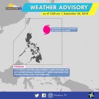
Now categorized as a Typhoon, Paeng was last spotted at 1,100 kilometers east of Tuguegarao City, Cagayan. It has maximum sustained winds of 170 kilometers per hour (kph) near the center and gustiness of up to 210 kph, moving at 20 kph. Although landfall is less likely to happen, the typhoon is expected to move west-northwest towards the Batanes-Babuyan Group of Island where Tropical Cyclone Warning Signals may be hoisted between Thursday and Friday.
Due to its proximity, the typhoon no direct effect on any part of the country yet. Today, partly cloudy to cloudy skies will prevail in the entire country but isolated rain showers are still possible.