Just three days after the World Meteorological Organization (WMO) announced that La Niña had ended, the Philippine Atmospheric, Geophysical and Astronomical Services Administration (PAGASA) announced the onset of the rainy season last June 4, 2021.
From October 2020 to March this year, a weak and moderate La Niña, which refers to the cooling of ocean surface temperatures, prevailed in the country. Coupled with the Northeast Monsoon or Amihan, it was predicted to bring above-normal rain conditions, which were seen in previous typhoons. On November 1 last year, Super Typhoon Rolly, 2020’s strongest tropical cyclone in the world, devastated 8 regions including Bicol. Floods, mudslides and storm surges affected 2 million people. In the same month on the 11th, Typhoon Ulysses struck Central Luzon, causing massive floods and landslides.
Now, the Southwest Monsoon or Habagat—warm and moist air that speeds up cloud formation that causes rainfall—has become the dominant weather system in the country. This is one of the factors that prompted PAGASA to declare the start of the rainy season. In a press statement, PAGASA administrator Dr. Vincent Malano explained, “The passage of Tropical Storm Dante and the occurrence of widespread rainfall in the last five days for areas under Type 1 climate confirm the onset of the rainy season. Intermittent rains associated with the Southwest Monsoon will continue to affect Metro Manila and the western section of the country.” The western parts of Luzon, Mindoro, Negros and Palawan fall under the Type 1 climate category.
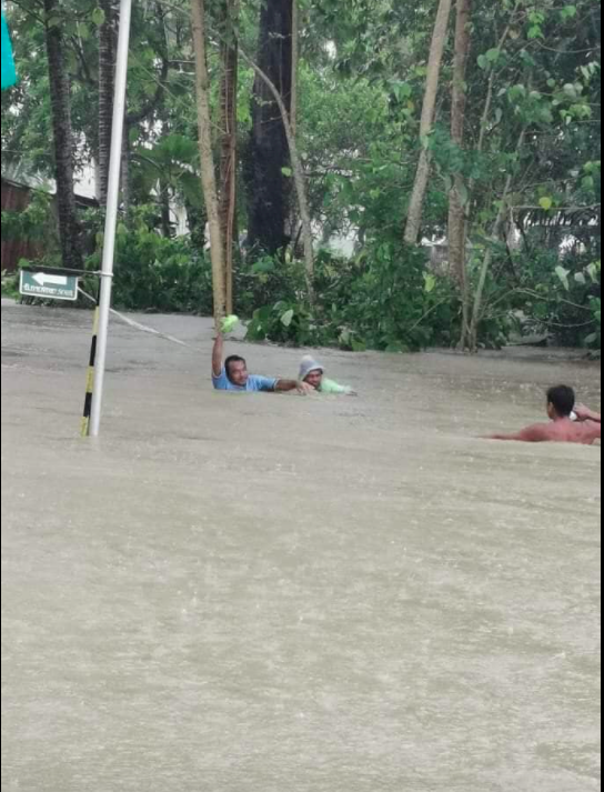 Massive flooding in Romblon due to the torrential rains brought by #DantePH. (Photos from PIA-Romblon)
The End of La Niña Does Not Spell Safety
With La Niña ending last June 1, WMO said that “neutral conditions are likely to dominate the tropical Pacific in the next few months.” PAGASA hydrologist Rosalie Pagulayan further explains, “There’s no La Niña, no El Niño, which means wind conditions have returned to normal. So, we can expect a normal amount of rainfall from June to September in the whole country.”
But as with everything related to the weather, nothing is set in stone. In WMO’s press release, the chance of neutral conditions continuing until July is at 78%. This decreases to 55% by August to October, while conditions are uncertain for the rest of the year.
Despite this high chance of neutral conditions, PAGASA warned that “The probability of near to above-normal rainfall conditions is high in the next two months (June-July.) The public and all concerned agencies are advised to take precautionary measures against the impacts of the rainy season.” Simply said, the end of La Niña does not mean that the country will be safe from tropical cyclone risks. “We can’t discard the possibility of extreme events,” says Pagulayan. “Our mindset should always be disaster preparedness.”
The Philippines is the country most-visited by tropical cyclones in the world. Here, the rainy season is synonymous with typhoons and floods. “This month of June, PAGASA forecasts that we may experience 1 to 3 tropical cyclones. Usually, tropical cyclone occurrences peak from July to September.” Though PAGASA announced there will be monsoon breaks or non-rainy periods which may last for days or weeks, Pagulayan stressed that we are currently in the thick of typhoon season.
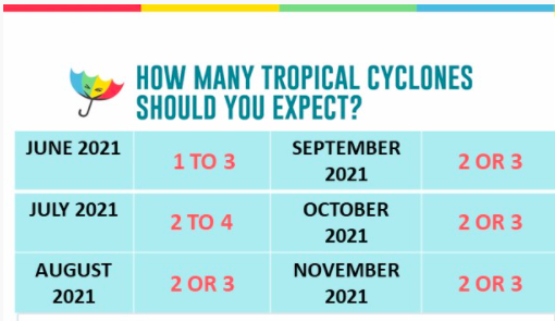 (source: PAGASA)
How Manmade Activities Worsen Natural Disasters
But despite the absence of La Niña, Tropical Storm Dante caused flash floods and landslides in Visayas and Mindanao earlier this month. The National Disaster Risk Reduction and Management Council (NDRRMC) reported 11 deaths and over 122,000 people affected. Damage in agriculture was pegged at over ₱90 million, while infrastructure damage was over ₱130 million. “The amount of rainfall Dante produced was staggering and unexpected,” admitted Pagulayan. “In my opinion, the change in landscape may have been a major contributor.”
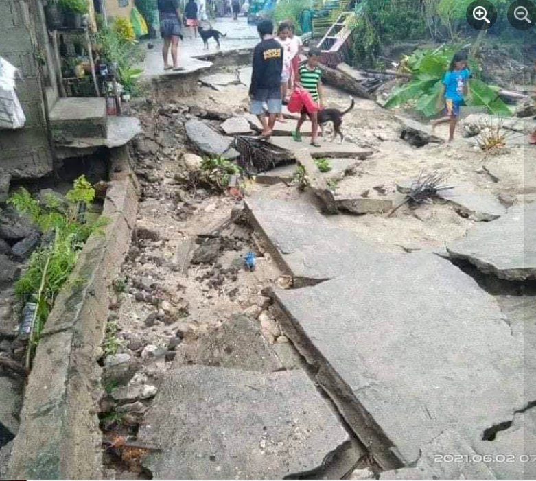 Aftermath of tropical storm #DantePH at Barangay Cabil-isan in Daram, Samar. (Photos courtesy of Slug Rosales)
Pagulayan refers to the altered natural environment brought about by human acts such as deforestation and development projects. In an earlier interview, Dr. Renato Solidum Jr, officer-in-charge of the Philippine Institute of Volcanology and Seismology, and undersecretary for Disaster Risk Reduction and Climate explained how manmade activities can worsen disaster impacts. “Landslides occur in steep places or those with soft ground. Destroying our mountains through deforestation or housing developments leads to faster erosion and lowland flooding. The eroded soil along with improper waste disposal fill up our rivers and drainages, also causing floods.”
WMO echoed this statement by saying that now that La Niña has ended, climate events are now in the hands of human-induced climate change. “La Niña has a temporary global cooling effect, which is typically strongest in the second year of the event. This means that 2021 has got off to a relatively cool start – by recent standards. This should not lull us into a false sense of security that there is a pause in climate change,” said WMO Secretary-General Prof. Petteri Taalas.
Taalas warned that carbon dioxide concentrations in the atmosphere remain high, fueling global warming. In fact, WMO predicted a 90% chance of at least one year between 2021 to 2025 to become the warmest on record. Soaring temperatures mean warmer oceans, which spell disaster. This, Pagulayan confirmed in a previous article. “Warmer oceans result to more evaporation. When there’s more moisture in the atmosphere, this may result in intensified tropical cyclones,” she said. “This means stronger rains, storm surges, and the possibility of tornadoes. Coastal communities will be inundated even those that do not usually experience floods. Heat waves may occur. While some parts of the country may experience droughts, other parts will receive excess rainfall. The greatest impact is on food production.”
Preparedness as a Personal Responsibility
It’s the second year we, Filipinos, find ourselves grappling with both the typhoon season and the COVID-19 pandemic. While this makes the management of evacuation centers challenging, Pagulayan stresses the importance of being pro-active when it comes to preparedness. “Let’s not rely solely on the government for our safety. Let’s ask ourselves what we an contribute.” She gives the following tips:
- Coordinate and work with your community’s disaster manager. Your community’s topography and needs are unique. You, your fellow-residents and barangay leaders can best map out a preparedness plan for your community.
- While staying alert to advisories released by your community’s disaster office, it’s also advisable to read updates from national agencies. Read the reports and listen to expert interviews. The additional knowledge boosts your preparedness by helping you form a bigger picture of possible scenarios.
- If you need to evacuate, always remember to bring a Go Bag. “This includes everything you need for the first 6 hours in the evacuation center,” says Pagulayan. Keeping yourself safe as an individual is a form of community service.

Weather forecasts are essential today as they were centuries ago. Our ancestors used observation methods to predict the weather, such as the loud croaking of frogs and the animals’ frantic scramble for shelter, believed to indicate imminent rain or stormy weather. Rain may also be preceded by a red sunrise, cloud towers on mountains, and a starless sky. The sound and sight of giant waves rolling are signs of a looming storm.
Meanwhile, the change of seasons is seen through the ripening of certain fruits. The proliferation of duhat, kaimito, langka and melon happens during the dry season, while the abundance of durian, guyabano, santol and siniguelas signifies the wet season. These observations are especially useful to farmers, sailors, and fishermen whose livelihoods are weather-based.
Fast forward to modern times, and weather forecasts are now available across all media platforms. Despite their accessibility, many are not aware of how much work is involved in coming up with reliable forecasts. According to PAGASA Weather Forecaster Aldczar Aurelio, the process requires several steps and the use of weather instruments. “We analyze weather maps (current and previous data), interpret the weather data coming from synoptic stations, monitor the images from weather satellites, analyze the outputs of numerical meteorological weather prediction, and discuss with fellow weather forecasters. It’s also important to know weather patterns or the behavior of weather systems for particular months or seasons.”
The Importance of Weather Forecasts
Because of our country’s geographical location, the Philippines is prone to natural disasters including tropical cyclones. According to PAGASA, about 20 tropical cyclones enter the Philippine Area of Responsibility, bringing with them hazards such as floods and destruction.
In October last year, Typhoon Ulysses entered the country during the pandemic, causing 67 deaths and more than P16 billion damage in agriculture and infrastructure. Though typhoons cannot be prevented, impacts can be mitigated through preparedness. According to Aurelio, weather forecasts can help in the following:
- Protecting life and property
- Helping people to dress accordingly and prepare weather essentials such as raincoats, umbrellas and sunscreen
- Serving as guides in power production and consumption. Energy production relies on weather elements such as wind speed, air pressure and air temperature.
- Helping people plan their activities
- Aiding businesses plan for transportation hazards such as thunderstorms, rains, and strong winds
- Helping people prepare for weather-related health issues such as allergies, asthma, and heat stress
- Helping communities plan for severe weather and weather hazards such as lightning, hail, flooding, and landslides
- Guiding the agricultural sector in planning for crop irrigation and protection
- Providing weather information for the tourism industry
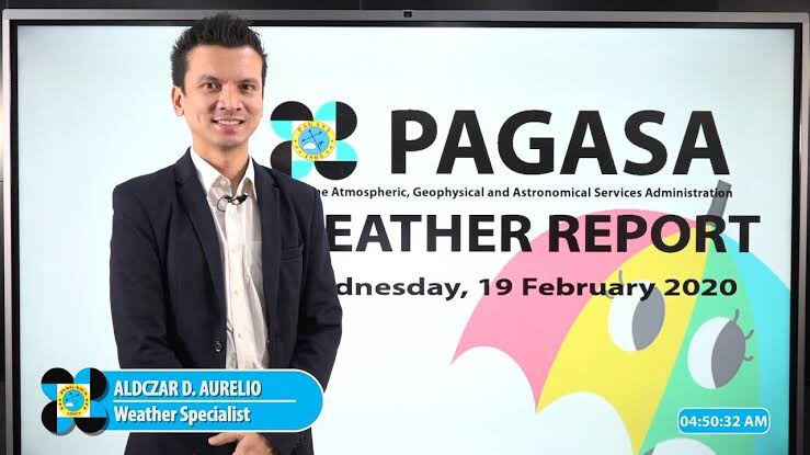 PAGASA Weather Specialist Aldczar Aurelio
Observing Weather on Your Own
Should you find yourself in a situation that hinders you from receiving weather forecasts, Aurelio suggests that observing your surroundings like what our ancestors did.

Cloud formations
Aurelio states that cloud observation is a basic foundation of meteorology. “There are three types of cloud formations. High clouds, middle clouds and low clouds,” he shares. “High clouds are associated with good weather— sunny, clear and fair. It’s ideal for outdoor activities. Middle clouds are associated with fair weather, but also with the brewing of bad weather. Low clouds are associated with bad weather—storms and rain. Cumulonimbus known as thunderstorm clouds are examples of low clouds. These low clouds are common during the rainy season.”
He also added some folk knowledge in predicting the weather, “When you see tower-like clouds, expect rain because those will bring thunderstorms. If you see a field [of clouds] on the base of clouds, it’s possible to experience a tornado.”

Stars
As to the popular belief that starless skies predict rain, Aurelio says that “Clouds that can cause severe thunderstorms cover the whole sky dome. “ But if a few stars are visible, then rain is still possible.
Given the ever-changing weather systems, forecasts are never 100% accurate. But the constant monitoring of weather forecasts and a keen awareness of our surroundings may boost our safety and preparedness. After all, we cannot escape the seasonal changes of our country’s weather even during a pandemic.
Within a month, from October 11 to November 12, a total of 8 tropical cyclones entered the Philippine Area of Responsibility—something that had kept weather forecasters from the Philippine Atmospheric, Geophysical, and Astronomical Services Administration (PAGASA) constantly on their toes. As an attached agency of the Department of Science and Technology (DOST), PAGASA is mandated to “provide protection against natural calamities. and utilize scientific knowledge as an effective instrument to ensure the safety, well-being and economic security of all the people, and for the promotion of national progress.”
Though the PAGASA team comes up with the weather forecasts and tropical cyclone warnings, viewers often see this information relayed by the TV networks’ reporters. This time, Panahon TV trains the spotlight on some of the Watchers of the Atmosphere themselves—the weather specialists that tirelessly work behind the scenes to constantly monitor all weather disturbances that pose a threat to our country.

Name: Chris Perez
Positions: Senior Weather Specialist
Immediate Supervisor, Weather Forecasting and Marine Meteorology Services Sections
Master’s Degree in Climate Change at the Australian National University in Canberra
Workshops Attended: The International Workshop for Weather Presenters in Vietnam (2015), Information and Communications Technology for Meteorological Services in Korea (2006)
How did you end up as a PAGASA weather forecaster?
After passing the Electronics and Communications Engineering Board Examinations in 2000, I worked in the private sector for 2 years. I then worked at PAGASA as a weather facilities technician, calibrating weather instruments. Then I applied for the one-year Meteorologist Training Course, which I passed. I was assigned to the Weather Forecasting Section in 2005.
What are your current duties?
Currently, I am tasked to oversee the day-to-day operations of the Weather Forecasting and Marine Meteorology Services Sections, particularly the formulation and dissemination of forecast products. Occasionally, I act as the agency’s spokesperson during inclement weather conditions.
What is your most memorable typhoon?
Super Typhoon Yolanda in 2013 because it exposed the weaknesses in our country’s disaster preparedness. It was the first time PAGASA issued a forecast while a cyclone was still outside the Philippine Area of Responsibility (PAR). I was part of the team that attended and updated the National Disaster Risk Reduction and Management Council (NDRRMC) prior to Yolanda’s entry to PAR.

Name: Ariel Rojas
Position: Weather Specialist
Master’s Degree in Meteorology at the University of the Philippines
Workshop Attended: Reinforcement of Meteorological Services in Japan (2019)
How did you end up as a PAGASA weather forecaster?
I was born and raised in Bicol where it always rains and tropical cyclones always visit. However, in college, I took up BS Food Technology. When I graduated in 2013, there was a brain drain of weather forecasters, so I applied for graduate school to study Meteorology under a PAGASA scholarship. When UP [University of the Philippines] shifted its academic calendar in 2014, I applied for a voluntary internship in forecasting, where I gained a lot of knowledge. I graduated in June 2017 and started working as a forecaster by November.
What are your current duties?
My main duties include analyzing weather data, maps, and models to formulate weather forecasts, and presenting the forecast product to the public through PAGASA’s online platforms and interviews with media outlets. I also conduct lectures on weather forecasting or other weather-related topics to media practitioners and students.
What is your most memorable typhoon?
I have several. The back-to-back strike of Urduja and Vinta in December 2017 because I’d been working in PAGASA for barely a month then. I cried over the number of deaths from the landslide and mudflow, especially during the passage of Vinta several days before Christmas.
Ambo this 2020 was also very memorable because it was the first typhoon during the pandemic. The forecasters and observers on duty were all holed up in the office to minimize the virus exposure. I was on duty for 9 straight days.
Rolly is also one for the books as it is the first super typhoon I’ve monitored since my employment in PAGASA. It started as a very small typhoon, the smallest I’ve seen on this side of the world. Tracking Rolly was very tricky as its forecast track kept changing due to the high pressure area which weather models weren’t able to properly project. Then it erupted into this year’s strongest cyclone and made landfall in my hometown Bato, Catanduanes, where my father was. It was very personal for me. I was trying to keep myself together while doing weather reports and updates left and right, but deep inside I was worried to death about my father’s situation. We sent him back to the province prior to the lockdown to keep him safe from COVID-19. Our town reported zero casualties and two days after the landfall, a cousin of mine shared a video of my father telling us that he’s okay.

Name: Benison Estareja
Position: Weather Specialist
Master’s Degree in Applied Meteorology and Climate with Management at the University of Reading (United Kingdom)
How did you end up as a PAGASA weather forecaster?
After graduating from the Southern Luzon State University with a degree in Electronics Engineering, I taught in the same school for two years. I was required to take my master’s but at that time, I wasn’t ready to fully commit to teaching. I heard about the Meteorologist Training Course from PAGASA, so I applied. When I got in, I quit my teaching job. The training lasted for eleven months. During that time, I realized that I’ve always been interested in forecasting. I remembered that when I was a kid, I’d see Ernie Baron on television. I told my mom that I wanted to be like him.
What are your current duties?
As one of the weather forecasters, I make PAGASA’s products such as the 5-day Weather Forecast, Asian Forecast, and the Tourist Destination Forecast. We write them and disseminate to PAGASA’s regional divisions and through social media. We also act as weather reporters on our YouTube and Facebook accounts every 5 a.m. and 5 p.m.
What is your most memorable typhoon?
Tropical Storm Mario in 2014 is memorable because it happened during my first week in PAGASA. Back then, I was living in Marikina and I couldn’t go to work because of the floods. It was ironic because the very thing I was supposed to work on was the same reason I couldn’t work. I called my supervisor, who, thankfully, understood why I couldn’t go to the office.
 Estareja at work
 Rojas on his first day of work with other forecasters (2017)
Challenges of Weather Forecasting
The weather forecasts Filipinos see on TV or hear over the radio may be concise and clear, but these are products of a tedious process built on data-gathering and sound decision-making. Rojas explains, “Weather presenting is only the tip of the iceberg. Forecasters analyze weather data, maps, and models to come up with the final forecast and all of these take time. Tropical cyclone events require more time and harder analyses.”
Estareja stresses that weather forecasting doesn’t only involve weather forecasters. “We get observations on different components such as temperature, rainfall, and wind from PAGASA stations scattered throughout the country. We also rely on radar observations. Satellite images from Japan and the U.S. are also very important.” To come up with the best possible forecast model, forecasters also gather data from the Japan Meteorological Agency, the Global Forecast System (GFS) from the United States’ National Weather Service, and the European Centre for Medium-Range Weather Forecast (ECMWF). “All these are bases for a weather forecast,” explains Estareja. “We see how consistent a piece of information is across all the models. From there, we decide on our output.”
Sometimes, forecasters are required to appear on television—a challenge that, Estareja admits, can be quite daunting. “Most of us are graduates of science-related courses with no background on communication. We had to learn those skills on the job.” To support such skills, Ube Media, Inc., which produces Panahon TV, held workshops for the forecasters. “We were taught the proper way of being a TV weather presenter—
from good grooming to being mentally and physically prepared. We even learned voice modulation to give emphasis on the certain points of a report,” says Perez. Estareja shares he has gained confidence from the workshops. “I learned how to move in front of the camera, the proper use of hand gestures, and how to emphasize words and emotions.”
To help PAGASA’s weather forecasts reach the younger set, Estareja has utilized social media with his Weather Wanderer persona. Combining his passions for travel and the weather, Estareja breaks down and simplifies weather forecasts—a move that has earned his Facebook page more than 8,000 followers to date.
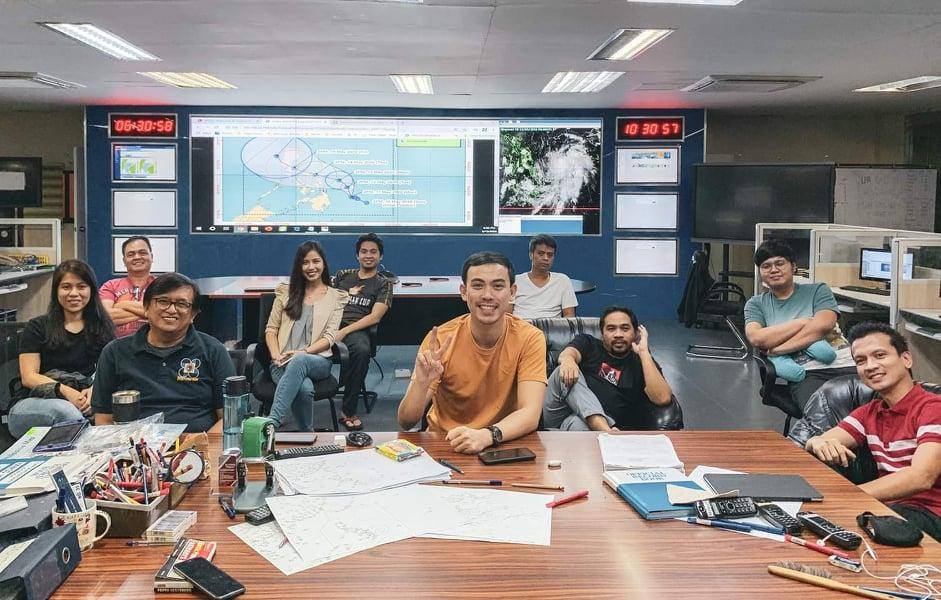 PAGASA’s team of weather forecasters during the country’s first typhoon (Ambo) of the year
Fulfillment from Forecasting
As the most tropical cyclone-visited country in the world, our weather forecasters have their work cut out for them. “We are in the business of saving lives—in the magnitude of thousands and millions all at once during the passing of tropical cyclones,” says Rojas. “It is a very tricky profession given the chaotic nature of weather (which we try so hard to predict) and the physical toll the work inflicts. But it’s a vocation. The fulfillment comes from knowing that thousands of lives are saved.” He says he is comforted when the public understands the magnitude of harm coming their way and is able to prepare for it. “I still have a long way to go but I try my best every single time. It’s not easy but then again, saving lives has never been easy.”
Perez echoes this sentiment. “When during and after a storm, there are no reports of inclement weather-related casualties, when the areas affected are able to recover quickly, when amidst the current pandemic, we still give reliable and timely weather and climate information that can further aid our frontliners in the delivery of the medical products and services for our countrymen—these are just some of the things that give us a sense of fulfillment.”
Estareja, a former teacher, also finds fulfillment in molding the youth. “A lot of them message me, telling me they also want to be PAGASA weather forecasters. It’s heartening to know that they are our future. I encourage them to finish a science-related course and continue improving their craft. Then they can fulfill their goal of working in PAGASA.”
But weather forecasters also have their goals for PAGASA. “I want PAGASA to be the best source of weather information for the Filipinos. I want it to be at par with the other weather agencies in the region. The agency has some of the most dedicated and most competent people in civil service and they need all the support and resources they can get to help the Philippines and the Filipino people weather hydrometeorological hazards,” says Rojas.
Estareja talks about the proliferation of weather forecasts on social media. “On Facebook, you see a screenshot of a satellite image and whoever uploaded it gives his or her own forecast. Other people research on the internet, and give their own forecasts.” This, he says, diverts public attention from PAGASA’s official forecasts. “A wrong interpretation of data can be a matter of life and death. Relying on bloggers or forecaster wannabes can be dangerous. At the end of the day, we want people to look at our forecasts and treat them as if their lives depended on it.”
For Perez, such goals are reachable with PAGASA’s continuous commitment to the Filipino people. “The agency will always be monitoring weather and climate-related events for them at all times, and it will continue to provide timely and reliable weather and climate information they can use for disaster preparedness, mitigation, resiliency and the further advancement of the country’s economy.”
Weather is no longer a mundane topic people use to make small talk. Nowadays, news about the weather makes Filipinos straighten up and listen because of the countless ways it impacts their lives. This is precisely what inspires PAGASA Weather Specialist Ariel Rojas when he delivers the forecast—with his eyes alert and his hand sweeping across the graphics-generated Philippine map.
“I’ve always been curious about the weather. I was born and raised in Bicol where it always rains and tropical cyclones always visit,” he shares. His journey toward weather forecasting began when he took up B.S. Meteorology in UP Diliman’s graduate school under a PAGASA scholarship. In 2017, he began working in PAGASA, and had since been trained here and abroad, allowing him to gain new knowledge and techniques in weather forecasting.
Rojas regularly appears on Panahon TV to deliver the weather forecast, but with Panahon TV’s first free webinar, Intro to Philippine Weather, he’ll get to share more of his knowledge. We sat down with him to delve deeper into his childhood passion.

What are your current duties in PAGASA?
My main duties include analyzing weather data, maps, and models to formulate weather forecasts, and presenting the forecast product to the public through PAGASA’s online platforms and interviews with media outlets. I also conduct lectures on weather forecasting or other weather-related topics to media practitioners and students.
Do you think it’s important for Filipinos to have basic weather knowledge?
Yes, it is! The Philippines is the most tropical cyclone-visited country in the world! That alone should be enough reason. We are also an agricultural nation so many farmers depend on the rain. Our economic, agricultural, and other daily activities are informed by the state of the atmosphere so basic weather knowledge is a must for everyone.
If there’s one thing you’d like every Filipino to know about weather forecasting, what would it be?
That weather presenting is only the tip of the iceberg. Forecasters analyze weather data, maps, and models to come up with the final forecast and all of these take time. Tropical cyclone events require more time and harder analyses.
How do you feel about being part of the Panahon TV webinars?
I always look forward to joining Panahon TV activities because they’re fun and I learn a lot. I feel honored to have been invited to take part in this webinar. I am also trying to further hone my communication skills so this would be a great platform for that.
What do you hope participants will take away from your workshop?
I hope that they will carry with them whatever little nugget of weather knowledge they can take away from the workshop. We basically experience the same weather patterns every year so just knowing when these patterns change can greatly help them in their decision-making, even the most mundane ones like choosing which clothes to wear or when to book an out of town trip.

To join Panahon TV’s free webinar Intro to Philippine Weather with Ariel Rojas on June 2, 2020 at 2:00 p.m., register at https://bit.ly/3d70vTk .

In case some of your wishes have yet to come true, try casting them on some shooting stars this week!
Meteors, also known as “falling stars” or “shooting stars”, are streaks of light caused by tiny bits of dust and rock called meteoroids falling into the Earth’s atmosphere. If any part of the meteoroid survives burning up after hitting the Earth, that remaining bit is called a meteorite.
The belief of wishing upon shooting stars dates back to around AD 127 to 151 when Greek astronomer Ptolemy wrote that occasionally, out of curiosity or even boredom, the gods peer down at the Earth from between the spheres. Stars sometimes slip out of this gap, flashing towards the earth.
SOUTHERN DELTA AQUARIDS METEORS
On its website, PAGASA announced that the Southern Delta Aquarids Meteor Shower will occur from July 28 to 31, and is estimated to peak starting on the late night of July 29 until early July 30.
These meteors will originate from the constellation Aquarius, the Water Bearer.

(photo from PAGASA)
BEST VIEW
Though the bright moon might interfere with the activity, those who are lucky might spot about 15 meteors per hour under good sky conditions.
According to astronomy website sky.org, the best viewing window for the Southern Delta Aquarids meteor shower from any time zone is between 2:00 to 3:00AM.
Before the shower’s peak, find an open sky, away from artificial lights. You may simply look upward at the window or lie down on a reclining chair.
Enjoy this astronomical event and remember to share with us your photos!
REFERENCES:
http://earthsky.org/?p=159138
http://www.pagasa.dost.gov.ph/index.php/astronomy/astronomy-in-the-philippines/28-astronomy/424-sky-this-month
http://starchild.gsfc.nasa.gov/docs/StarChild/questions/question12.html

Formerly Bagyong Chedeng, now a Low Pressure Area, is expected to exit the Philippine Area of Responsibility today before dissipating.
From an almost supertyphoon intensity, Chedeng weakened as it moved closer to the archipelago due to cold air intrusion and strong vertical wind shear, both factors hindering the retention of the cyclone’s strength.
Added to this is land interaction. When Chedeng’s center hit Dinapigue, Isabela, 8 in the morning of April 5, it gradually became a LPA.
Now estimated at 215 kms. northwest of Laoag, Ilocos Norte, the LPA will bring cloudy skies and rains over the regions of Cordillera, Ilocos and Cagayan Valley. Metro Manila, and the remaining parts of the country, on the other hand will experience a fair weathered Monday, apart from isolated rain showers or thunderstorms.
Meanwhile, a new tropical cyclone is spotted outside the PAR. A tropical storm category, this cyclone has an international name of Haishen. PAGASA estimates the cyclone at 2,560 kms. east of Mindanao.
Weather forecaster Glaiza Escullar says this cyclone is too far to affect the country and is actually expected to weaken in the following hours. Therefore, Pinoys do not have to worry about Haishen entering our area of responsibility in the following days.

PAGASA declares the termination of the northeast monsoon season in the Philippines, marking the start of the hot and dry season in the country.
With this development, the ridge of high pressure area and the easterlies will be the dominant weather systems in the coming days.
These systems bring generally good weather and warm days in most areas of the Philippines. However, this does not mean we are free from possible wet days.
Isolated cases of rain showers and thunderstorms may also happen due to the following:
1. Urban Heat Island Effect – wherein the concrete structures and the ground are unable to absorb and trap heat from the sun. The warmer the air over the city,the higher its capacity to hold more moisture.
These factors combine to create convergence and lead to thunderstorm formation in a particular locale, especially over the cities as their surfaces are prone to release large quantities of heat.
2. Wind Convergence – wherein two different air masses meet–winds coming from the northeast and the easterlies.
The convergence of the cold and dry air of the northeast winds, and the warm and humid air of the easterlies generate cloudy skies with light to moderate rain showers or thunderstorms.
On the other hand, seafarers may enjoy calm coastal waters aside from at times moderate waves due to the possible prevalence of the easterlies, particularly over Eastern Luzon and Visayas.
Stay cool this hot season. Take precautionary measures to protect yourself from various heat-related illnesses. Read here: http://www.panahon.tv/blog/2015/03/staying-cool-this-hot-season/
Every March, Women’s Month is celebrated worldwide. This observance is rooted in the different activities of women in the early 20th century, where women’s rights and other social concerns were raised. These include low wages, lack of protection and the unjust working conditions of women workers during that time.
Looking back at the time before the mid-19th Century, education for women was limited as they were taught to mostly focus in religion, singing, dancing and other skills and knowledge that would prepare them in their traditional roles of being wives and mothers.
Back then, teaching was the only acceptable occupation for women. There was a wide gender gap in most professions, especially the male-dominated fields of science, including meteorology.
According to the National Oceanic and Atmospheric Administration (NOAA), more women officially began entering the world of weather forecasting in 1942 because men were needed in the war. When Pearl Harbor was bombed, only two women were working in the observation and forecast staff of the Weather Bureau in the United States.

In 1942, the Weather Bureau issued the following announcement:
OPPORTUNITY FOR WOMEN IN METEOROLOGICAL WORK
“Although there has been much prejudice against and few precedents for employing women generally for professional work in meteorology, perhaps a dozen women have obtained meteorological positions in the last few years, mostly outside the government service. However, since there is at present an acute shortage of both trained meteorologists and men for observers and clerical positions in the Weather Bureau and other government agencies, airlines, etc., women with the proper qualifications (same as for men) are now being welcomed in many places where they were not encouraged even last year. (In England women have already taken over many meteorological posts, we hear.) Therefore, women with training or experience in meteorology or its branches should apply immediately for any of the current or forthcoming U.S. Civil Service examinations in meteorology which are open to them… This will be an opportunity to join the vanguard of the many women who will very likely find careers in meteorology in the not too distant future and at the same time it will be a patriotic choice in case the war should require many women to replace or supplement men as meteorologists.”
Over 900 women became part of the Weather Bureau, mostly in clerical positions or as junior observers. Many of them worked as temporary employees but were changed to permanent status later on.
Here are some of the women in history who excelled in conventionally male disciplines like science and mathematics, leading them to leave their mark in the field of meteorology:
Sarah Frances Whiting (1847-1927, American)
Whiting did not have the chance to obtain formal education but her father, Joel Whiting, tutored her in mathematics and physics. As the first woman to join the New England Meteorological Society, she assembled a meteorological station where she imparted her knowledge by teaching. Her students gathered data for the U.S.Weather Bureau.
She was also known for establishing the first physics laboratory for women and the astronomical observatory in Wellesly. Whiting set up the second undergraduate physics laboratory, and was able to produce the first X-ray photographs in the United States.
Famous for using the spectroscope, a wiring diagram for an apparatus utilized in generating electric sparks, Whiting also wrote several astronomical articles and was able to publish a book entitled “Daytime and Evening Exercises in Astronomy.”

Eleanor Anne Ormerod (1828-1901, English)
Provided by her mother with a general education, Ormerod learned to speak and write in various languages including English, French, Latin, Italian, Spanish, Dutch and Norwegian. She was known for her illustrations that complemented her published works.
Ormerod was awarded by the Royal Horticultural Society for her study of insects, determing which were beneficial for gardeners and which were pests.
She became interested in meteorology when she moved to Torquay with his brother, George Wareing Ormerod, who took meteorological observations and became a Fellow of the Royal Meteorological Society in 1874. Because of him, Ormerod’s curiosity about the weather and its relationship to insects grew.
Ormerod later on became the first woman Fellow of the Royal Meteorological Society. She built her own meteorological station at Isleworth, published manuscripts and assembled decades of observations from other weather stations.

Caterina Scarpellini (1808-1873, Italian)
Scarpellini was the founder of the Meteorological Ozonometric Station in Rome. As a meteorologist in Rome, she preserved records of the weather and ozone conditions, and was able to publish different manuscripts about ozone and coastal squalls.

Eleanor Stabler Brooks (1892-1986, American)
Wife of a founder of the American Meteorological Society, Charles S. Brooks, Eleanor Brooks was also a known meteorologist herself. She worked at the Blue Hill Observatory and became an indexer for the Bulletin of the American Meteorological Society for ten years.
The Brooks couple helped each other in producing a daily weather article for newspapers entitled “Why the Weather?” and was later on published as a book.
Joanne Simpson (1923-2010, American)
Because of her fascination with clouds as she sailed in her small catboat, Simpson became interested in the weather. After her Master’s Degree, she moved on to a Ph.D. program. That time she was told by a faculty member that no woman ever got a Ph.D.in meteorology and if anyone did, she would still end up unemployed.
Instead of losing hope, Simpson completed a course under Herbert Riehl, known as the “father of tropical meteorology”. She focused on tropical cumulous clouds and with her strong perseverance, was able to make Riehl her Ph.D. advisor.
She filmed clouds on long flights and drew maps of cloud formations. Simpson was the first meteorologist to reveal patterns that are now shown by satellites that helped describe the role of clouds in global atmospheric circulation. Simpson pursued her studies and observations, leading her to become the first woman to hold a Ph.D.in meteorology.


Mentioned above are just some of the women who excelled in the history of meteorology. This only proves that women have contributed a remarkable impact in the field of science. What we have today and how we track the atmosphere are fruits of their exceptional ideas, ideas that will come a long way and will lead to future innovations.
Sources:
http://passporttoknowledge.com/storm/who/bios/women1.htm
http://earthobservatory.nasa.gov/Features/Simpson/simpson2.php
http://www.history.noaa.gov/stories_tales/women6.html
https://books.google.com.ph/books?id=nFt6csjzc48C&pg=PA462&lpg=PA462&dq=Sarah+Frances+Whiting+meteorology&source=bl&ots=GyEPnoaBK6&sig=eBpKk3U2SXiFzKkZ6lH3Lp3caJw&hl=en&sa=X&ei=SZn-VMC-MtH48QW8s4GwAw&ved=0CEwQ6AEwDA#v=onepage&q=Sarah%20Frances%20Whiting%20meteorology&f=false

The Philippine Atmospheric Geophysical and Astronomical Services Administration, commonly known as PAGASA, is the country’s official meteorological and hydrological services provider—which means that the bureau is more than just about the weather. Read on to discover what other things PAGASA busies itself with.
PAGASA studies heavenly bodies. Astronomical events such as the blue moon, falling stars, and lunar and solar eclipses, offer us an extravagant show in the sky. To let us know when we can enjoy these heavenly displays, PAGASA has a pool of astronomers that closely monitor such events. The bureau’s astronomy divisions is located at the PAGASA Science Garden in Quezon City and at the University of the Philippines Diliman Observatory, where the public can observe the stars and planets.
PAGASA is the country’s official timekeeper. The Philippine Standard Time (PhST) is also one of PAGASA’s services. For meteorologists, this allows accurate documentation of the atmosphere at certain time frames, which serve as the initial basis of forecasting weather and floods. For seismologists, PhST helps in determining the epicenter of an earthquake. Under Presidential Decree 1149, PAGASA was declared as the official agency to disseminate PhST.
PAGASA takes part in nation-building. By being immersed in climatological studies, PAGASA helps in creating sustainable projects by providing both public and private sectors information that will enhance the country’s capability to adapt to environmental changes. It also conducts regular Information and Education Campaigns (IEC) in Local Government Units and the academe for disaster preparedness.
PAGASA has specific weather forecasts. Aside from the 24-hour public weather forecasts disseminated to the public, PAGASA also caters to specific clients, such as farmers and fishermen. Its Farm Weather Forecast gives details on what temperatures should be expected in upland and lowland farms, as well as the range of relative humidity and leaf wetness which helps in maintaining the quality of crops. Meanwhile, its Shipping Forecast provides information regarding the maritime safety, providing gale warnings that notify fishermen and other maritime services of sea conditions.
PAGASA is everywhere. The weather bureau has 58 synoptic stations, 23 agromet stations, 10 radar station and 7 upper air stations planted throughout the archipelago. Each of these stations has different instruments used to measure temperature, atmospheric pressure, wind speed, wind direction, humidity and the amount of rainfall over the area. All these daily weather observations are then transmitted to PAGASA’s Weather and Flood Forecasting Center in Quezon City.
With all these responsibilities under its belt, PAGASA strives to continue to live up to its acronym—giving hope to the nation in different ways: helping the public prepare for weather changes, assisting the country’s backbone workforce, and telling us when we can lie on our backs and wish on stars that streak across the night sky.