For the past weeks, the water level in Angat Dam, which supplies 97% of Metro Manila’s water needs, has been slowly but continuously decreasing. According to the Climate Outlook Forum of the Philippine Atmospheric, Geophysical and Astronomical Services Administration (PAGASA) last September 23, the dam’s level was at 177.3 meters, 32.67 meters less than its normal water level of 210 meters.
But according to Rosalie Pagulayan of the Hydro-Meteorological Division of PAGASA, historical data in the past 14 years shows that Angat Dam’s water level typically dips during this time.
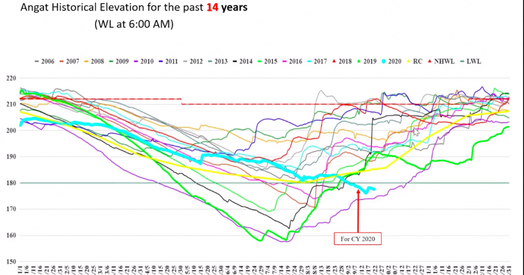 Angat Dam’s current downward trend in light blue (graph from PAGASA)
“Its level continues to decrease, but we expect it to increase during the Northeast Monsoon. Even with no typhoons, we can expect Angat Dam to recover in the last quarter of the year,” says Pagulayan. This is based on the forecast rainfall of PAGASA’s Climatology and Agrometeorology Division, which shows an expected 386 millimeters in October, 294 millimeters in November and 129.5 millimeters in December.
Forecast Rainfall for the remainder of 2020
| October | 386 millimeters |
| November | 295 millimeters |
| December | 129.5 millimeters |
Metro Manila’s Main Water Source
The Angat Reservoir and Dam is located in the Angat Watershed Forest Reserve in Norzagaray, Bulacan. According to Manila Water, the dam supplies the water requirements of Metro Manila, and irrigates about 31,000 hectares of farmlands in Pampanga and Bulacan. It also generates hydroelectric power for the Luzon Grid, and holds water to reduce flooding in downstream towns and villages.
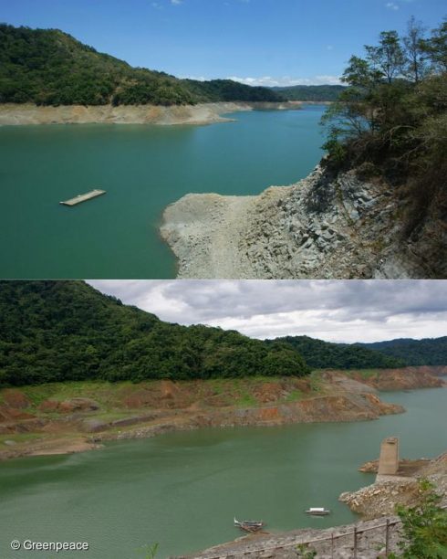 Top photo of Angat Dam taken last April 13, 2010 when water levels hit the critical 180 meters above sea level. Photo at the bottom with the structure completely exposed, was taken last July 16, 201, when levels reached a historical low of 157.55 meters. (Top photo by Joseph Agcaoili /Greenpeace. Bottom photo by Gigie Cruz-Sy /Greenpeace)
The dam usually stores enough water for Metro Manila’s 30-day supply. But El Niño, which refers to the unusual warming the oceans giving way to higher temperatures, can affect dam levels. On July 18, 2010, Angat Dam decreased to its all-time lowest level of 157.55 meters, the difference from its normal level roughly equivalent to the height of an 18-storey building. Because of El Niño, rain was below-normal, drying up the rivers that led to Angat Dam. Irrigation in Bulacan and Pampanga was cut to give way to the water needs of Metro Manila, which still experienced service interruptions. The government distributed relief goods among farmers and their families because they were unable to harvest.
Last year’s El Niño brought the Angat Dam down to 159.43 meters, just 2 meters more than its lowest record in 2010, prompting the National Water Resources Board to further reduce the allocation for Manila Water and Maynilad Water Services. Over 6 million residents of Metro Manila, Rizal and Cavite experienced daily rotational water interruptions from six hours to as much as 21 hours. Because of this, hospital operations and businesses were affected with some restaurants, carwashes and laundry shops closing temporarily.
 Residents waiting by the roadside for fire engines to fill up their water containers in 2019
Why We and our Dams are in Danger
According to the World Population Review, Manila is now the most densely-populated city in the world with over 42,000 residents per square meter. Data from the Philippine Statistical Authority shows that over 21.3 million people live Metro Manila.
Overpopulation created a spike in water demand, especially during the sweltering El Niño season of 2019, one of the reasons a Manila Water representative pointed out as the cause of reduced water levels in dams. But the water crisis is a global one, which the Union of Concerned Scientists in the U.S. also attributes to climate change. Global warming alters the water cycle, affecting the “amount, distribution, timing and quality of available water.” While a warmer climate speeds up the evaporation of water on land and in oceans, it also holds more water that can be released through devastating typhoons, causing massive floods.
The Philippines’ water crisis also extends to limited access to water and sanitation outside the metropolis. The World Health Organization states that out of the 105 million living in the Philippines, around 7 million depend on water sources that are unsafe and unsustainable. In fact, one of the country’s leading causes of death in 2016 was acute diarrhea, causing over 139,000 fatalities.
An unreliable water supply severely affects public health, pushing people to look for other drinking water sources that may be unsafe. Basic hygiene—a must during this pandemic—is also compromised as one needs to thoroughly wash themselves, their clothes and their food to prevent infections from COVID-19 and other illnesses. When water pressure in pipes are low because of scarce supply, elements can contaminate the water once the pressure is restored.
Before Manila Water implemented rotational service interruptions in October last year, Metro Manila residents went on panic mode and stored water ahead of time. The move lowered water pressure, limiting its flow and distribution toward high places. WHO also cautions against the improper storing of water as this can allow mosquitoes to breed, possibly increasing the risk of diseases such as dengue fever.
Solving the Water Crisis
While individuals are responsible for their own health and safety by making sure their drinking water is safe and free from contamination, WHO states that the government also needs to provide long-term solutions. Groundwater and surface water from rivers and lakes will not last long when exacerbated by climate change and a growing population.
“Strategies such as the application of improved rainwater collection systems and state-of the-art desalination technologies coupled with renewable energies can be used in the Philippines,” says Environmental health technical officer in WHO Philippines Engineer Bonifacio Magtibay on the WHO website. “By adopting innovative and long-term solutions, the Philippines can ensure water for all that will protect the peoples’ health and help drive sustainable development forward.”
Pagulayan also reiterates that though PAGASA expects Angat Dam to recover, residents must not be complacent. “We have always called for the responsible use of water. This is a very important commodity because we use it for almost all our activities. Even if we’re not experiencing El Niño or other weather systems, we should always be looking at how we can maximize our resources. Let’s not waste water.”
For more tips on conserving water, watch this.
For more details on the Angat Dam, watch Panahon TV’s report.

In a press release dated January 18, 2017, the World Meteorological Organization (WMO) confirmed that 2016 was the hottest year on record. With a global average temperature of 1.1 degrees Celsius higher than the pre-industrial period, it surpassed the heat recorded in 2015.According to WMO, it was approximately 0.07 degrees Celsius warmer than the previous year.
A strong El Niño event was assumed as one of the main factors that fuelled high temperatures during the early months of 2016. However, high temperatures prevailed even after the El Niño episode.
Climate change is the long-term shift in weather patterns in a region. This includes changes in precipitation, temperatures, sea levels and many more. It is also a phenomenon brought by the increased emission of greenhouse gases in the atmosphere.
According to Dr. Rosa Perez of the Intergovernmental Panel on Climate Change (IPCC), Climate change can be caused either by natural occurrences or human activities. Natural causes include the sun’s activity, volcanic eruptions and other natural events that contribute to the warming of the earth.
But the problem now is that climate change has worsened due to human activities, such as the burning of fossil fuels, clearing of forests, improper waste management and production of industrialized products.

Among the greenhouse gases, carbon dioxide has one of the most ample concentrations in the atmosphere. In September last year, carbon dioxide levels have exceeded the tipping point or the harmful threshold of 440 parts per million (ppm). This figure indicates more catastrophic events like extreme drought, melting of ice, sea level rise and stronger typhoons in the future.
2016 was filled with extreme weather events, leaving socio-economic disruption and losses. The warming of the ocean has contributed to widespread coral bleaching.
Recently, the United Nations reported that three-quarters of the world’s coral reefs are expected to be exposed to terrible heat by 2070. Reefs closer to the equator face annual bleaching that may occur at an earlier frequency, affecting more than 75% of the reefs.
Coral bleaching happens once the micro plants called “zooxanthellae” leave the corals when the water becomes warm because of climate change. This leads to the deprivation of the corals’ food source and color, turning them white or bleached. If the heat persists for a longer period of time, the corals may die. When this happens, it will take decades for reefs to recover or worse, they may not recover at all.
(insert image)
PH ratification of Paris Agreement underway
“Addressing global warming shall be our top priority, but upon a fair and equitable equation. It must not stymie our industrialization.” These were the words uttered by President Rodrigo Duterte during his 1st State of the Nation Address (SONA) in July 2016.
Earlier this year, Duterte announced that he will be signing the Paris Agreement by July 2017. Before the agreement reaches our President, 33 government agencies and private groups have to submit their respective Certificates of Concurrence first. These certificates will serve as a guarantee that the agencies understand, approve and are willing to cooperate in the implementation of the pact.
Sources:
World Meteorological Organization (WMO)
Climate Home
Climate Central
PAGASA
Rappler
Science Daily

New studies from the International Atomic Energy Agency (IAEA) researchers showed that climate change does not only affect the severity or amount of rain but also the precipitation patterns.
According to Al Gore, the founder of the Climate Reality Project, since warmer air holds more moisture, rising global temperatures also contribute to the changes in rain patterns, including rain’s occurrence, duration and distribution. Gore also stated that global water vapor increases by 7% for every degree centigrade of warming.
Climate change can affect two types of rain – stratiform and convective. Convective rain, which occurs more frequently, is sudden, intense and local. Meanwhile, the stratiform type is lighter and can fall over a larger area for a longer time.
Isotopes as clues
In June 2016, hydrology specialist Pradeep Aggarwal and his co-authors announced that the oxygen and hydrogen isotopes in rain samples provided data on the ratio of these two rain types.
Isotopes are atoms of the same element that have different numbers of neutrons that result to different atomic weights. The condensation and evaporation of water affect the ratio of heavy to light isotopes.

Observing and understanding how the water cycle responds to climate change is difficult and critical. These findings could also contribute to a better understanding of how climate change affects rainfall patterns, which could later help in adaptation and precipitation models in the future.
Rainfall and Climate Change
As temperatures rise, air becomes warmer. Hence, more moisture evaporates from land and water into the atmosphere. More moisture in the air means more precipitation and heavy downpour.
The problem is that extra rain is not evenly distributed throughout the globe. Because of the shifting air and ocean currents brought by climate change, some countries may receive more or less precipitation than others. According to the US Environmental Protection Agency (EPA), the world is already getting more rain and snow than it did a century ago.

Looming La Niña
PAGASA and other international meteorological agencies confirmed a 55 to 60% probability of La Niña development in the last quarter of 2016. La Niña is the unusual cooling of ocean temperatures in the Central and Eastern Equatorial Pacific.
Because of this weather phenomenon, more active rainfall activity is expected in Southeast Asia, including the Philippines. PAGASA said that after the sweltering dry months, we are now anticipating slightly cooler and wetter months ahead.
Rising temperatures triggered by climate change and the previous El Niño episode may begin to decelerate due to La Niña. According to the University of New South Wale’s Climate Change Research Center, a rise in global temperatures may still occur, but it won’t be as rapid as what had been observed last year.

Sources:
PAGASA
US Climate Prediction Center
International Atomic Energy Agency
University of New South Wale’s Climate Change Research Center
US Environmental Protection Agency

In line with Tropical Cyclone Week, the Philippine Atmospheric Geophysical and Astronomical Services Administration (PAGASA) conducted a La Niña Forum last June 15, 2016. This year’s theme, Tag- baha at Tag-bagyo, Handa na Tayo!, aims to prepare the public for the impacts of the increasing probability of La Niña.
La Niña is defined by the National Oceanic and Atmospheric Administration (NOAA) as a phenomenon characterized by the unusually low sea surface temperatures or cooling of the ocean in the Equatorial Pacific. As the opposite of El Niño, La Niña will bring more rains, and moderate to strong tropical cyclone activities.
According to the Chief of PAGASA’s Climate Monitoring and Prediction Section (CLIMPS), Mr. Anthony Lucero, El Niño is still in its decaying stage. It continues to weaken and is more likely to return to neutral condition by the end of June or July.
Though El Niño is currently weakening, Lucero explained that most parts of the country may still feel its impact. Many provinces may still experience below-normal rainfall until next month.
Majority of climate models show a possible development of La Niña during the second half of 2016. Despite this forecast, Lucero said there will be less tropical cyclones this year. “Talagang magkukulang tayo ng bagyo ngayon… pero nangyari na ito noon, walang unusual o abnormal dito.” (We will experience less tropical cyclones, but this has already happened before. Nothing unusual or abnormal about it.)
Annually, the average number of tropical cyclones that enter the Philippine Area of Responsibility (PAR) is 19 to 21. We’ve already covered half of 2016, yet there is still no sign of a tropical cyclone. According to PAGASA, 8 to 14 tropical cyclones are expected to enter or develop within the boundary from June to November, and possibly a maximum of 16 until December.
Meanwhile, in a separate interview with PAGASA Weather Forecaster Gener Quitlong, he explained that after a strong El Niño episode, our country is likely to experience less number of tropical cyclones. This happened in 1972-1973, wherein we had only 12 tropical cyclones, and 11 tropical cyclones in 1997-1998.
New PAGASA Services
In preparation for the flood and cyclone season, PAGASA continues to upgrade their services. A book entitled, “Patnubay sa Weder Forkasting” was launched this week. This aims not only to simplify technical terms, but also to familiarize everyone with weather terms in other local languages, such as Ilokano and Bikolano.
The creation of the book was headed by the Komisyon sa Wikang Filipino, in close coordination with the weather bureau. Being the first-ever Filipino weather dictionary, it serves as a response to President Noynoy Aquino’s appeal for a more understandable and simplified way of crafting weather forecasts.
Here are some of the commonly used words included in the dictionary:


PAGASA also introduced an updated version of their mobile application, which includes weather information and flood alerts.
This app is a product of the collaboration between PAGASA and the Japan International Cooperation Agency (JICA). Now available for android phones, it can be downloaded through Google Play.
Meanwhile, reading materials, which include information about La Niña, Rainfall Warning System and the Tropical Cyclone Warning System (formerly known as Public Storm Warning Signal), were also launched at the forum. This is part of the Be Sure Project which was successfully made through the help of the United States Agency for International Development (USAID).

The online community is abuzz after a Miss Earth Philippines contestant shared her insights in the Q & A portion of the beauty pageant.
During the coronation night last June 11, candidates were each given 30 seconds to elaborate on trending topics they had picked from a basket.
Miss Zamboanga, Bellatrix Tran, drew #ElNiñoLaNiña, two weather-related events that are serious global threats.
This was Tan’s answer: “El Niño is what we are facing right now. If we do simple things like planting trees, then we will not experience drought. So if we start now, we will achieve La Niña.” Unfortunately, her last line elicited laughter from the audience and judges.
https://twitter.com/krizzy_kalerqui/status/741797696269225985?ref_src=twsrc%5Etfw
What should have been her answer:
Everyone should read up on El Niño, a climatic condition wherein an unusual increase in sea surface temperature or warming of the ocean is observed. It mostly affects the agricultural sector due to its effects of reduced rainfall and warmer weather.
In the Philippines, PAGASA confirmed the start of the El Niño phenomenon last May 2015. To date, El Niño is at its decaying stage but has left damages worth P7 billion based on the records of the Department of Agriculture from January to May 2016.
Meanwhile, the National Oceanic and Atmospheric Administration (NOAA) defines La Niña as a phenomenon characterized by unusually low sea surface temperatures or the cooling of the ocean in the Equatorial Pacific. Its effects may include moderate to strong monsoon activity, moderate to strong tropical cyclones, above-normal rains or above -normal temperatures. A La Niña episode does not always follow an El Niño, but it may happen especially if the latter is a strong one.
As of posting, there is no confirmed occurrence of La Niña, but there is a 50% chance that it will develop in the coming months, according to PAGASA.
Miss Philippines Earth aims to showcase not just nature’s beauty, but to also raise awareness on social concerns and environmental issues, including weather phenomena.
So remember that whether you’re planning to join a beauty contest or not, remember that it pays to be equipped with knowledge on social issues, especially those that are directly affecting our country.
While El Niño is drawing closer to its end, it may still have an effect in several parts of the country this month. Dry condition may affect the province of Marinduque ,while dry spells are expected in Benguet, Ilocos Norte, Ilocos Sur, La Union, Batanes, Cagayan, Isabela, Nueva Vizcaya, Quirino, Aurora, Batangas, Laguna, Oriental Mindoro, Romblon, Albay, Camarines Sur, Sorsogon, Eastern Samar, Leyte, Northern Samar, Western Samar, Southern Leyte and Davao Oriental.
Meanwhile, droughts continue to threaten Abra, Ifugao, Kalinga Apayao, Mountain Province, Bataan, Bulacan, Nueva Ecija, Pampanga, Tarlac, Zambales, Occidental Mindoro, Palawan and Masbate.
In Visayas, droughts are likely to be experienced in Aklan, Antique, Capiz, Guimaras, Iloilo, Negros Occidental, Negros Oriental, Bohol, Cebu, Siquijor and Biliran. Affected areas in Mindanao include Zamboanga Sibugay, Camiguin, Lanao del Norte, Misamis Occidental, Misamis Oriental, Davao del Sur, South Cotabato, North Cotabato, Sarangani, Surigao del Norte, Sulu and Tawi-Tawi.
El Niño is now on its final stage, and is more likely to return to neutral condition by the end of July. While this may bring good news to our farmers highly affected by extreme drought, meteorological agencies warn the public about the impending occurrence of the La Niña.
The National Oceanic and Atmospheric Administration (NOAA) defines La Niña as a phenomenon characterized by the unusually low sea surface temperatures or cooling of the ocean in the Equatorial Pacific. NOAA added that a La Niña episode does not always follow an El Niño, but it may happen especially if the latter is a strong one.
The chief of PAGASA-Climate Monitoring and Prediction Section (CLIMPS), Mr. Anthony Lucero, said La Niña episode may occur on October to December 2016. As of now, there is a 50% chance that it will develop in the coming months.

According to PAGASA Weather Forecaster Buddy Javier, the La Niña’s effects in the Philippines may include the following:
1. Moderate to strong monsoon activity
The southwest monsoon or habagat is expected to affect the country during the rainy season, which usually sets in by the end of May to early June. If La Niña occurs, the activity of habagat may intensify, bringing more rains in the country.
2. Moderate to strong tropical cyclone activity
La Niña may also influence the intensity and impacts of tropical cyclones or bagyo that will enter the Philippine Area of Responsibility (PAR) in the second half of 2016.
3. Above-normal rainfall / wetter weather condition
The opposite of El Niño, La Niña means more rains. More rains may trigger more flooding and landslides. After months of extremely dry days, we must now prepare for extremely wet days.
4. Near to below-normal air temperatures
By the time La Niña fully develops, the tag-init season may have already ended. Temperatures may return to normal or may be below average.
PAGASA will continuously monitor the weather while advisories will be immediately issued if needed. The public is advised to monitor updates.

By Amor Larrosa and Desserie Dionio, Panahon TV Reporters
Gunshots echoed as protesters hurled stones against the police. Blasts of water cannons were directed toward rallyists, who ran for their lives amidst deafening screams. According to reports, such was the scene that unfolded in Kidapawan in Cotabato that took the media by storm on the first day of April – an incident that would later be tagged by others as “Bigas, Hindi Bala.”
On March 29, 500 El Niño-stricken farmers and agricultural workers staged a rally in front of the National Food Authority (NFA) in Kidapawan City to ask the government for rice rations and aid after the El Niño had dried up their crops, leaving them penniless, in debt and hungry.
The local government agreed to talk to the farmers, but on March 30, their numbers rose to 6,000, allowing them to occupy the highway. A couple of days later, the event led to a violent dispersal, killing two farmers and one civilian, with more than a hundred protesters and members of the police wounded, and 80 farmers missing.
TWO SIDES OF THE COIN
Last April 7, the Senate Committee on Justice and Human Rights held a hearing in Davao City as some of farmers who were still recovering from injuries could not travel to Manila.
During the session, a farmer named Arlyn Oti Aman recalled how she, along with colleagues, were treated violently. “We went here to ask for food, but they looked upon us as like dogs, like animals.”
Meanwhile, the Philippine National Police (PNP) claimed that they have proof that the demonstrators initiated the violence. North Cotabato Chief Police Senior Supt. Alexander Tagum said that maximum tolerance was implemented during the outbreak of violence. He also showed an aerial video of the incident showing that cops were not raising their batons.
There are always two sides to every story, but what’s certain is that one of the factors that sparked the Kidapawan violence is the El Niño. This phenomenon aggravated the Dry Season in Mindanao, threatening food security.
WHAT IS EL NIÑO?
El Niño is characterized by the unusual warming of the ocean or the unusual rise in sea surface temperature (SST). According to the National Oceanic and Atmospheric Administration (NOAA), the term El Niño was originally recognized by fishermen off the coast of South America as the appearance of uncommon warm water in the Pacific Ocean.
“El Niño” is also a Spanish term meaning “Little Boy” or “Christ child” because this phenomenon usually arrives around Christmas.
WARNING
As early as 2014, PAGASA warned the public about the possible threat of El Niño, which was expected to bring below-normal rainfall patterns and higher air temperatures. Though the average number of tropical cyclones could still be normal, PAGASA stated that the El Niño could affect the cyclones’ movement and intensity, causing them to be stronger and more erratic.
EL NIÑO SETS IN
On March 11, 2015, PAGASA confirmed the ongoing El Niño in a press statement.
In the same month, the Dry Spell started to affect farmlands and water sources in Kidapawan City. The veterinary office in the city also reported deaths of hogs and cows because of the severe heat. The city office also received reports that some farm animals had weakened, possibly due to heat stroke.

After enduring the effects of El Niño for months, North Cotabato was placed under a state of calamity on January 2016. Thousands of hectares of farmlands and millions of crops like rice, corn, cacao, and other high-value crops were affected.
MINDANAO’S WEATHER
Provinces that are vulnerable to the effects of El Niño are mostly in Mindanao, mainly because of its location. According to PAGASA-Climate Monitoring and Prediction Section (CLIMPS) Chief Mr. Anthony Lucero, areas which are at the nearest distance from the equator normally experience the highest temperatures and least precipitation.
“Kapag kasi may El Niño, nagkakaroon ng reversal of winds—5 degrees north and 5 degrees south of equator. Humihina ‘yung effect ng Easterlies pagdating sa part na ‘yun. So walang moisture, wala ring ulan,” Lucero said.
This April, North Cotabato remains to be on the list of areas that are more likely to experience drought. Drought is defined by three consecutive months of way-below normal rainfall condition, wherein the average rainfall is reduced by 60%.

WERE WE PREPARED FOR EL NIÑO?
In the Senate Committee hearing, Cotabato Governor Emmylou Taliño Mendoza stressed that the provincial government took El Niño-mitigating measures after being warned by PAGASA.
Meanwhile, the Department of Agriculture (DA) Secretary Proceso Alcala belied reports that farmers in Mindanao have become hungry because of the government’s failure to prepare for El Niño. According to Alcala, when PAGASA declared a mild El Niño, the DA immediately provided P2.666 billion worth of mitigation assistance as early as 2015. He also said that P979.9 million worth of assistance was released from January to March 2016, including the provision of water pumps.
According to Alcala, DA’s projection of palay harvest loss due to El Niño for 2016 to date is 970,000 metric tons; “But the actual loss was 203,000 metric tons, meaning that the government has implemented the necessary interventions.”
From April to July this year, DA targets to distribute a total of 89,260 bags of rice varieties and seeds; 80,000 kilograms of soil ameliorant/zinc sulphate; and 5,000 bags of organic fertilizer for distribution to affected farmers.
As early as January, Pasig City Representative Roman Romulo called for the administration to disclose how it intended to spend the multimillion-peso budget for El Niño mitigation.
Likewise, in his statement during the hearing, Majority Floor Leader Alan Peter Cayetano condemned the administration for its failure to immediately release funds to mitigate the effects of El Niño.
“Enough of excuses and lies: we actually have P45 billion worth of funds in 2016 that may be used for the projects that will curb the impact of this crisis. If the Palace wanted to resolve this, they can… why are there so many farmers who are still starving and facing poverty?” said Cayetano.
EL NIÑO AND CLIMATE CHANGE
In an interview with the World Wide Fund for Nature (WWF), Atty. Gia Ibay said climate change does not cause El Niño, but the frequency of El Niño occurrence may be linked to it.
Lucero affirms this, saying it is a common misconception that El Niño is caused by climate change. He added that though El Niño is a natural occurrence, climate change may worsen its effects.
“Sa nakikita natin in the recent years, dumadami at dumadalas ang pagkakaroon ng disasters dahil sa climate change – kasama dun ‘yung drought. Ang climate change, connected sa pagtaas ng temperatura ng mundo. So kapag nagkaroon ng El Niño, lumalala ang effect. Mas mainit at lalong nagkukulang sa ulan,” Lucero explained.
According to Lucero, the current El Niño is still categorized as “strong” but is expected to weaken in the next few months. Probably by the end of July, our country may experience a “neutral” climatic condition.
AWARENESS + PREPAREDNESS
To date, the PNP has started its own inquiry on the Kidapawan dispersal, but there are calls for the National Bureau of Investigation (NBI) to conduct a parallel probe to ensure an impartial and independent investigation.
Meanwhile, in Senator Loren Legarda’s press release, she said that this incident would not have happened if necessary interventions addressed the impact of El Niño on farmers and communities.
“…the government can no longer deny the link between climate change and development. What we saw is just one of the human faces of climate change and our farmers, who did not cause this phenomenon, is among the direct victims of its impacts,” Legarda stated.
With the increasing frequency of El Niño and extreme weather events, it is evident that we are already facing a serious challenge. We have all been warned about the development of an El Niño phenomenon, but awareness is not enough without preparedness. It is the state’s responsibility to see to it that measures are effectively carried out from planning to implementation, making sure that the very backbone of the country’s food security—the farmers—benefit from them.
Related articles:
Panahon TV Blog: Decrypting the Dry Spell
Panahon TV Blog: El Niño getting stronger, threatens PH until 2016
REFERENCES:
http://davaotoday.com/main/human-rights/we-were-treated-like-animals-woman-tells-senate-hearing-on-kidapawan-carnage/
http://news.pia.gov.ph/article/view/1541460006387/senate-hearing-on-violent-kidapawan-protest-held-in-davao
http://www.da.gov.ph/index.php/media-resources/news-release/2016-news-release/7456-agri-chief-belies-media-reports-that-mindanao-farmers-going-hungry-due-to-el-nino
http://www.gov.ph/2016/04/05/govt-intensifies-efforts-combat-el-nino/
https://www.senate.gov.ph/press_release/2016/0407_escudero2.asp
National Oceanic and Atmospheric Administration (NOAA)
PAGASA-DOST
Greenpeace Philippines
www.mindanews.com
http://www.philstar.com/nation/2016/01/21/1544611/north-cotabato-under-state-calamity-due-el-nino
http://www.senate.gov.ph/press_release/2016/0405_legarda1.asp
PAGASA’s climate outlook shows that most parts of the Philippines will probably experience a Meteorological Drought, which, according to the National Centers for Environmental Information, occurs when dry weather patterns dominate an area. Meanwhile, Agricultural Droughts happen when crops are affected.
Because of the ongoing El Niño, the forecast rainfall for February is below-normal or between 41 to 80 percent. Based on the map below, a large part of Luzon, Visayas and Mindanao will experience less rainfall. These include the Cordillera Administrative Region (CAR), except for Apayao where near-normal rainfall is expected.
In Region I, Ilocos Norte, Ilocos Sur and La Union will receive above-normal rainfall. However, Pangasinan will experience a different scenario with only a 22.9 percent amount precipitation in February, which means drought is more probable in this area.
The good news: most provinces in Region II, Central Luzon, National Capital Region, Region IV-A, MIMAROPA and Bicol Region will also receive below to above-normal rainfall, thanks to the Amihan or the Northeast Monsoon and occasional Tail End of a Cold Front, bringing light to moderate rains.
In Region VI, Negros Island Region, Region VII, Region VIII, Davao Region, SOCCSKSARGEN, CARAGA and ARMM, below-normal rainfall is expected, quantified between 41 to 80 percent. The Zamboanga Peninsula and Northern Mindanao are most likely to experience the effect of El Niño this month because of way-below normal rainfall or below 40 percent amount of rains. Most of these areas consist of agricultural farms, thus making it more prone to Agricultural Drought.
According to PAGASA, A Dry Spell is characterized by three consecutive months of below- normal rainfall conditions, while Droughts are defined as having three consecutive months of way below-normal rainfall conditions. In the latest climate outlook of the weather bureau, 26 provinces (31% percent of the country) are likely to experience droughts.

Lanao Del Norte in Region X reported that there are 1,216 hectares of corn, 976 hectares of high-value crops and 694 hectares of rice affected by the Dry Condition. Meanwhile, 22 municipalities of Bukidnon are also suffering from the effect of El Niño, with 31,750 hectares of corn, 1,705 hectares of cassava and 4.0,317 hectares of rice affected by the Dry Season. Maguindanao in ARMM is now placed under a State of Calamity, where more than 20,000 farmers and 17,000 hectares of rice and corn are affected.
The Department of Agriculture (DA) is focusing on providing mitigation programs especially to areas severely affected by the El Niño. Cloud seeding, the process of scattering silver iodide aerosols or dry ice into clouds containing supercooled water to induce rain, is done to abate water scarcity.
The DA is also awaiting the release of a P900 million budget to fast-track the agency’s interventions.
With the unfavorable effects of El Niño, farmers are assured that they can rely on DA. The agency is accepting concerns and inquiries through its DA El Niño Hotline and PhilRice Text Center.


It crosses borders on social classes, age and gender. When it comes to the dengue fever, no one is safe.
It’s a viral disease that can be spread through the Aedes aegypti mosquito, whose breeding habitat thrives in wet climates like what we we have in our country. This is because these mosquitoes lay their eggs in stagnant water and flooded areas.
According to the World Health Organization (WHO) there is an estimated 390 million dengue infections a year– of which 96 million are clinically manifested. Meanwhile, the Department of Health (DOH) recorded 92,807 dengue cases as of September last year– 23.5% higher than the recorded cases in 2014.
Climate Change and Dengue
Due to the strong El Niño the Philippines is continuously experiencing, DOH expects to have a higher number of dengue cases this year. This is because El Niño can cause stronger typhoons that can lead to flooding, which can contribute to dengue production. Increased stagnant water leads to an increase of dengue-carrying larva. And because more people are storing water to survive the water shortage, this may also be a factor in the spreading of the virus, according to the DOH.
The extreme temperature and drought in some areas are also favorable conditions for the virus. When the weather is cold, mosquitoes hibernate, which may lead to their death. During dry conditions, their eggs can survive for months.
Other factors that cause dengue
According to DOH spokesman Dr. Lyndon Lee Suy, the increase in globalization, urbanization and jet travel make human interaction more frequent. Where there are crowded areas, the practice of storing water may be common because of the stiff competition for water sources because of the El Ñino.
In a highly urbanized area, such as Metro Manila, wet markets abound with questionable hygienic practices. It is because of this that the DOH is strongly urging the people to keep their surroundings clean, and to always cover stored water.
Did you know?
Dengue can be found in tropical and sub-tropical climates worldwide, and mostly in urban and semi-urban areas. These are cities and towns where human structures like houses, commercial buildings, bridges, railways, and bridges can be found. The higher the population, the faster the rate the dengue virus can spread.


Dengue Vaccine
Department of Health Secretary Janette Garin announced last December that the first vaccine against dengue will be available in the country this month. This medicine was tested and approved by the Food and Drug Administration, and was manufactured by French pharmaceutical giant Sanofi Pasteur. The vaccine is suitable for all four types of dengue patients, ranging from 9 to 45 years old.
But you can still prevent dengue through these simple routines:
· Regularly clean your area.
· Use mosquito nets over your bed.
· Wear long sleeves.
· Use mosquito repellant.
· At the onset of any symptom above, immediately consult a doctor.
· Support local fogging in your area.