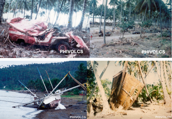
Just after midnight on August 17, 1976, a magnitude 8 earthquake shook the areas around Moro Gulf in Mindanao, including Cotabato City. But the disaster did not stop there; less than 5 minutes later, a tsunami as high as 9 meters roared and swallowed 700 kilometers of coastline. When the sea ebbed to its peaceful state, around 8,000 had died from the combined effects of the earthquake and tsunami, with the latter accounting for 85% of deaths and 95% of those missing and never found. The event, now known as the 1976 Moro Gulf Earthquake, is recognized as the deadliest earthquake that ever hit the country.
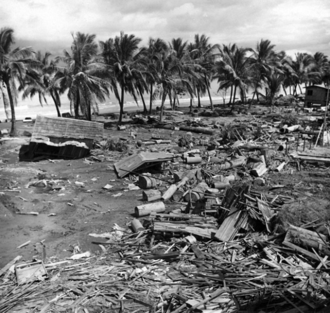 Devastation of the 1976 tsunami at Barangay Tibpuan in Lebak, Mindanao (Photo from Wikimedia Commons)
Almost two decades later on November 15, 1994, Mindoro was rocked by a magnitude 7.1 earthquake. Like what happened in Mindanao, majority of the 78 casualties of the Mindoro earthquake was due to the 8-meter high tsunami that occurred 5 minutes after the quake.
The truth is, though Filipinos are aware of devastating tsunami happening in other countries like Japan and Indonesia, they do not often associate these natural disasters in their homeland. But as past events indicate, deadly tsunami can occur locally. As Undersecretary of the Department of Science and Technology (DOST) for Disaster Risk Reduction-Climate Change Adaptation (DRR-CCA) and Officer-In-Charge of the Philippine Institute of Volcanology and Seismology (PHIVOLCS) put it, “Tsunami are very fast in the Philippines and we need to prepare for them.”
Tsunami 101
In observance of World Tsunami Awareness Day last November 5, PHIVOLCS organized an online press conference to spread the word about tsunami. Mostly generated by under-the-sea earthquakes, tsunami are characterized by a series of waves with heights of more than 5 meters. According to Solidum, such earthquakes can be triggered by underwater landslides, volcanic eruptions, and the more unlikely meteor impacts. These cause the seafloor to lift, causing the water it carries to rise.
There are two types of tsunami—the distant and local. Distant or far-field tsunami is generated outside the Philippines, mainly from countries bordering the Pacific Ocean like Chile, Alaska (U.S.) and Japan. With these events being monitored by The Pacific Tsunami Warning Center (PTWC), the Philippines has 1 to 24 hours of preparation before the tsunami’s arrival, depending on its origin.
But with local tsunami, lead time is cut down to a mere 2 to 10 minutes after the earthquake. “Preparedness is very important because rapid response is needed for locally-generated tsunami. The trenches are where the large earthquakes and tsunami can be generated, and we are only the country wherein trenches can be found on both sides. Hence, both sides of the country need to prepare for tsunami. Aside from that, the eastern side of the country faces the Pacific Ocean or the Pacific Ring of Fire where earthquakes and tsunami can also be generated,” said Solidum.
What PHIVOLCS is doing
Part of the Tsunami Risk Reduction Program of PHIVOLCS are the Tsunami Hazard Mapping and Modeling, and the Tsunami Hazard Risk Assessment, both of which aim to understand tsunami, manage their hazards and risks, and identify priority actions for response and recovery. To detect possible tsunami, PHIVOLCS set up its Monitoring and Detection Networks Development.
Aside from the 107 seismic stations that receive data for earthquakes and tsunami, there are also 29 real-time tide gauges all over the country. Through the hazards and risk-assessment software code REDAS, PHIVOLCS can evaluate potential earthquake hazards, create tsunami simulations, and predicting the number of affected people. “The total population exposed to tsunami would be close to 14 million,” said Solidum. “But they will not be affected at the same time. It would depend on where the tsunami would occur. In NCR, for example, the prone population would be around 2.4 million. And the next highest would be 1.6 million in Region VII, 1.2 million in Region VI— and in Region IXA, around 1 million.”
Meanwhile, HazardHunter Philippines, which is open for public use, can assess hazards depending on the user’s specific location. “HazardHunter can also give you a more detailed tsunami hazards assessment because it can provide you a map showing the different areas that will be affected by different tsunami heights. It is color coded, indicating areas prone to various tsunami heights.” Solidum appealed to the public to take advantage of the “Report a Disaster” website. Here, people can post pictures and videos of current risks and hazards in their areas, and describe disasters impacts, which can help the government’s risk and impact assessments.
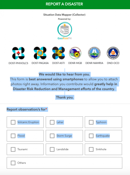 Screencap of “Report a Disaster” website
“In the Philippines, we use a simple tsunami information or warning scheme,” explained Solidum. “We will evacuate once the tsunami information is categorized as a tsunami warning. We expect a destructive tsunami of more than 1 meter and this would need immediate evacuation of coastal areas. Boats at sea are advised to say offshore — in deep waters.”
Shake, drop and roar
Because local tsunami can be very fast, people need to know its natural signs:
Shake – refers to a strong earthquake.
Drop – refers to the sea level receding fast.
Roar – refers to the unusual sound of the returning wave, which indicates a tsunami.
After an earthquake, Solidum recommends for people near the shore to immediately move to elevated ground inland, or take refuge in tall and strong buildings. “If they have not moved at all, once they hear the tsunami and there are unusual sounds, there might not be enough time. They really need to respond immediately,” warned Solidum.
PHIVOLCS also released tsunami safety and preparedness measures on their website:
- Do not stay in low-lying coastal areas after a felt earthquake. Move to higher grounds immediately.
2. If unusual sea conditions like rapid lowering of sea level are observed, immediately move toward high grounds.
3. Never go down the beach to watch for a tsunami. When you see the wave, you are too close to escape it.
4. During the retreat of sea level, interesting sights are often revealed. Fishes may be stranded on dry land thereby attracting people to collect them. Also sandbars and coral flats may be exposed. These scenes tempt people to flock to the shoreline thereby increasing the number of people at risk.
Solidum stressed the importance of community-based preparedness, built on planning and drills to create the following output:
- development of evacuation plans based on the hazard maps
- installation of different types of signage (signage for hazards, signage for the evacuation area, signage for the directions to go to the evacuation area)
- conducting of seminars and lectures
- drills
Tsunami preparedness during COVID-19
The devastation of several typhoons this year, coupled with the country’s location in the Pacific Ring of Fire, are proof that the Philippines is prone to various hazards. Because of the
COVID-19 pandemic, Solidum admitted that PHIVOLCS had to rethink their training methods. “Before, we actually go down to various coastal communities and conduct lectures in the evening, so that people who worked in the daytime can also attend. But the pandemic has enabled more people to listen because of the social media platform and our webinars. We’ve reached more people in terms of information campaign. But we hope that local government disaster managers will do the actual preparedness at the community level.”
Solidum noted that though COVID-19 continues to cause loss of lives and the disruption of public services, mobility and economic development, tsunami can create far more devastating impacts. “We will see the physical impacts through buildings, infrastructures, property, water supply pipes, electrical supply, communication system, roads, bridges, and ports. This is in addition to the physical impact on people because of the collapsing houses or the impact of the large volume of water. We have science, technology, and innovation from DOST that can help in preparedness and disaster risk reduction. We need to use it, but we need to share this information to the communities and the public,” he ended.
Watch the full press conference from PHIVOLCS.
Watch Panahon TV’s primer on tsunami.
Managing the rainy season this year is vastly different from the previous ones as the Coronavirus Disease 2019 (COVID-19) continues to pose threats on the country’s public health, economy, and environment. During this time, tropical cyclones, combined with the enhanced southwest monsoon (habagat), are expected to bring floods, storm surges, destructive winds, and landslides which may hamper efforts in curtailing the spread of the virus. According to the Philippine Atmospheric, Geophysical and Astronomical Services Administration (PAGASA), 6 to 10 cyclones may enter the Philippine Area of Responsibility (PAR) from July to August. Additionally, there is a 50% chance that La Niña may develop in the last quarter of the year, bringing wetter conditions in the eastern section of the country.
 Typhoon Season. Two tropical cyclones have traversed the PAR since the first COVID-19 case in Manila on January 30. Typhoon Ambo, internationally known as Vongfong, made landfall six times on May 14 and 15, while Tropical Depression Butchoy hit the landmass twice on June 11. Both pummeled the coronavirus-stricken Luzon.
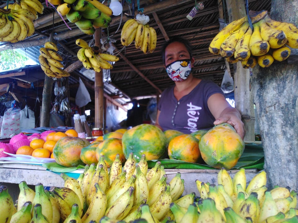
Aylen Labiano, who has been selling agricultural products beside an ecotourism road in Lucena, Quezon for nearly a year now, recounts in Filipino how Bagyong Ambo impacted her livelihood. “The recent cyclone devastated vegetation and banana trees, which prompted suppliers and sellers to raise prices. But people want low-cost food since a lot of them lost their jobs, and the situation has not yet normalized. If typhoons continue to ravage our livelihood, we will not be able to make ends meet.”
 Agricultural Uncertainty. Agricultural loss due to Typhoon Ambo is estimated at Php1.37B.
19-year old Carl Ian Pedregosa from San Francisco, Quezon shares how his family monitored the news to prepare for the typhoon. “But when the rains arrived, we experienced power outage, which lasted for more than a week. Some coconuts, which were supposed to be extracted for oil, also fell during the storm. We fed them to the hogs instead.” Pedregosa also worries about how power interruptions can not only make it difficult for his family to stay updated, but also disrupt his education in the coming school year, especially with academic institutions planning to utilize online learning.
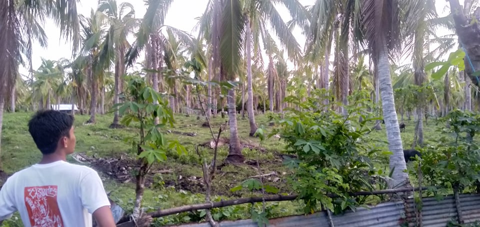 Felled coconut trees in Quezon Province, one of the top agricultural producers of copra in the country.
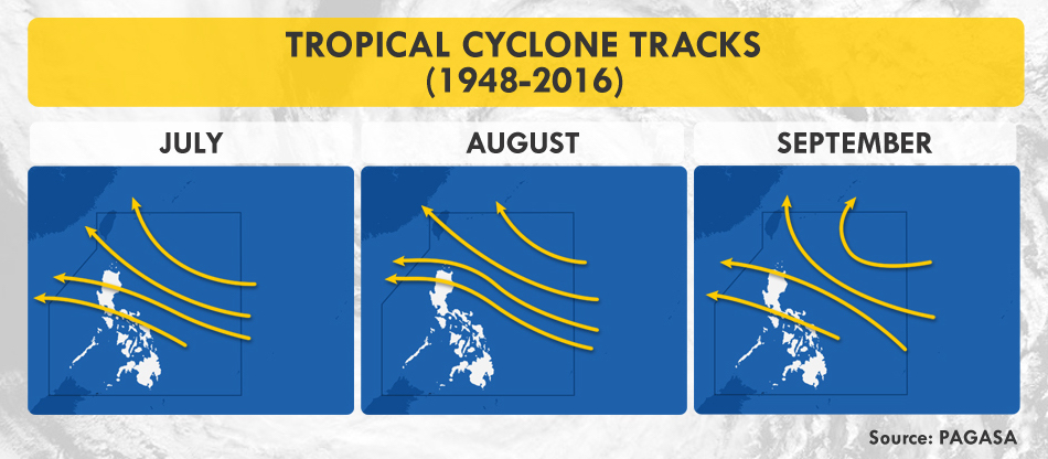
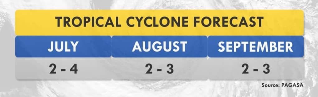 PAGASA Cyclone Forecast
Overwhelming Complications
While studies say that rain may help dilute the virus on contaminated surfaces, it also favors other diseases that may strain our healthcare system.
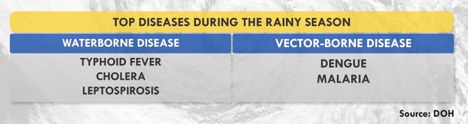 Monsoon Diseases. With the rains comes a downpour of diseases, ranging from the easily curable, such as diarrhea and cough, to the downright deadly, including leptospirosis and typhoid fever. Meanwhile, the World Health Organization (WHO) clarifies that there is still no evidence supporting the possible transmission of COVID-19 through mosquitos and houseflies. To date, no peer-reviewed studies have proven that the ongoing seasonal change has weakened the potency of the virus, and if it can interact with other viruses to develop worse symptoms.
But the real problem lies with how symptoms of monsoon diseases are almost similar to those of COVID-19’s. “Whether people tested positive or negative for COVID-19, we will need to test them for other possible diseases which will make the process longer,” states Dr. Generoso Roberto of the Philippine Society of Public Health Physicians (PSPHP).
The Department of Health (DOH) targets to license 65 COVID-19 testing laboratories by the end of July to test 1.5 to 2% of the population. To date, there are 62 accredited labs with a rated testing capacity of 50,000 daily, prioritizing suspect cases, individuals with travel history, and healthcare workers with possible exposure, whether they are symptomatic or asymptomatic. However, there is still a gap between rated and actual capacity with 12,000 to 16,000 people tested a day due to manpower and supply chain issues— problems that arise globally.
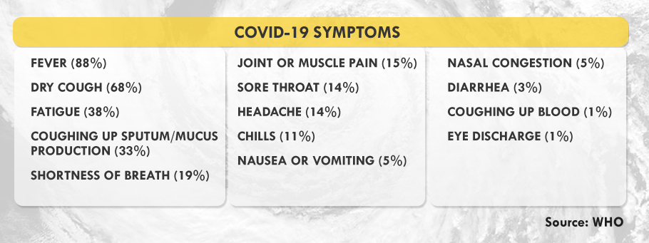 Confirmed Symptoms. The United Kingdom has included anosmia, or loss of taste or smell, as a predictor for COVID-19. Experts say that patients infected with COVID-19 usually transmit the disease before their symptoms manifest, their ability to infect peaking until the third day after symptoms start showing.
“We also need to plan where we’ll be admitting patients diagnosed with other diseases if certain hospitals are designated as COVID-19 treatment sites,” Dr. Roberto explained. Meanwhile, people living in rural areas, especially in remote islands, will face the challenge of transporting patients and doctors to the barrios during the typhoon season. “This means that patients can develop severe symptoms by the time they’re brought to healthcare facilities,” Dr. Roberto explained.
Though virtual healthcare seeks to keep patients at home, the system is not inclusive of, and accessible among the marginalized. According to the Speedtest Global Index, upload and download speeds for mobile and fixed broadband in the country are still below the global average. The Social Weather Stations (SWS) also shows that only 22.4% of Filipino families in the country owns a personal computer at home.
Rising Tide of Vulnerabilities
The country is still on its first wave of COVID-19 cases when the government gradually eased quarantine measures, allowing some businesses to reopen. Though this move aims to save the economy from socioeconomic impacts, such as unemployment and hunger, it may also worsen, not only the health crisis, but also disaster risks.
“We need to do scenario building or disaster imagination so we can prepare for complex emergencies,” says Science and Technology Undersecretary Renato Solidum, Jr. in Filipino. Government and private sectors should have continuity plans for their public service and businesses since the pandemic may coincide with hazards that often transpire in the country, such as earthquakes, tsunamis, and volcanic eruptions.
On March 11, days before the Enhanced Community Quarantine (ECQ) in Luzon, volcanologists placed Mount Kanlaon in Negros Island under Alert Level 1, prohibiting people around its 4-kilometer-radius danger zone for possible sudden phreatic eruptions. A series of volcano-tectonic quakes has been observed since June 21. Meanwhile, Mayon Volcano has been under Alert Level 2 since March 2018.
Urbanized cities are highly exposed both to the pandemic and the negative impacts of natural hazards due to their dense structures and population. According to Solidum, the government’s Balik-Probinsya program may be a good solution to decongest cities as long as comprehensive safety protocols are strictly employed. This program, institutionalized through Executive Order No. 114, seeks to encourage people, especially the informal settlers, to return to their home provinces.
Metro Manila, considered as the seat of government, is no exception to looming catastrophe. Here lies the biggest portion of the West Valley Fault (WVF), an active earthquake generator traversing Bulacan, Quezon City, Marikina, Pasig, Taguig, Muntinlupa, Rizal, Laguna, and Cavite. These areas are part of the Greater Metro Manila Area (GMMA), a megacity with an estimated population of 20 million. About 35% of its populace are informal settlers, many of them living below poverty line.
WVF’s massive earthquakes occur every 400 to 600 years. Its last movement that caused a magnitude 5.7 quake was in 1658 or 362 years ago. According to a joint study by Australia and the Philippines, the fault’s next movement may produce a magnitude 7.2 earthquake, resulting in 34,000 deaths due to collapsed buildings—and an additional 18,000 fire-related fatalities in the metropolis. Furthermore, infrastructures, lifelines, and about 40% of residential buildings are likely to be heavily or partially damaged, causing 2.3 trillion pesos worth of damage. The management of such a huge disaster requires close coordination, which the current pandemic hampers.
If protocols are not properly implemented and followed, evacuation centers during disasters coupled with monsoon diseases may be a breeding ground for more health risks. A person with COVID-19 may infect dozens of people, including Disaster Risk Reduction and Management (DRRM) officers who are on the frontline during rescue and relief operations.
One of which is Alex Pimentel, a DRRM officer in Batangas City, who tested positive for the disease in April. “Parang nandidiri ang ibang tao sa community, lalo na when I tested positive,” he shares. (When I tested positive, people in the community avoided me like the plague.)
DRRM offices help by providing transportation for COVID-19-related patients, manning centers for Persons Under Monitoring (PUM), and disinfecting public spaces, among others. But if a natural disaster strikes, people like Alex will even have a more difficult time doing their duty. “It will be hard for the DRRM frontliners responding with merged Search and Rescue and COVID-19 personal protective equipment. We also worry about funds because we’ve already spent so much during the Taal eruption, assisting 11,000 evacuees, followed by the pandemic response.“
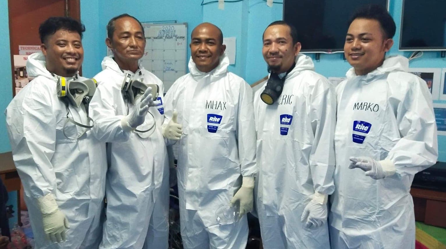 Nasugbu, Batangas LDRRMO
The Need for Disaster Imagination
Solidum explains that disaster imagination means preparing for worst-case scenarios and their possible impacts. “People and the Local Government Units (LGUs) should know the hazards in their areas so they can plan appropriately. What if an earthquake transpires? What are its impacts? Have we identified the vulnerable population? Where are we bringing them?”
A study conducted by the International Organization for Migration (IOM) in 2014 exposed that more than 90% of evacuation sites in Eastern Samar were partially or completely devastated during the onslaught of Typhoon Haiyan, locally known as Yolanda. These were churches, schools, and community centers, which were identified by LGUs as safe.
On June 13, the Office of Civil Defense (OCD) provided LGUs with guidelines so they can meet the health standards of the COVID-19 National Task Force in conducting online Pre-Disaster Risk Assessment. This allows LGUs to prepare their inventory of resources, logistical requirements, relief packs, and evacuation centers. “If we conduct pre-emptive evacuation, we see to it that everybody is protected. We should be observing social distancing and we limit the number of people in the evacuation centers. We also see to it that our responders are protected,“ says OCD’s Operations Service Director Harold Cabreros.
Risk Management during the Pandemic
The Philippine Institute of Volcanology and Seismology (PHIVOLCS), PAGASA, and the Mines and Geosciences Bureau (MGB) have developed Hazard Hunter, a tool that Filipinos can use to assess seismic, volcanic, hydrometeorological, and climatological hazards in their locations. It is free and readily- available online, especially useful for property owners, buyers, land developers, planners, and other stakeholders.
It is also important to know what to do before, during, and after several natural hazards.
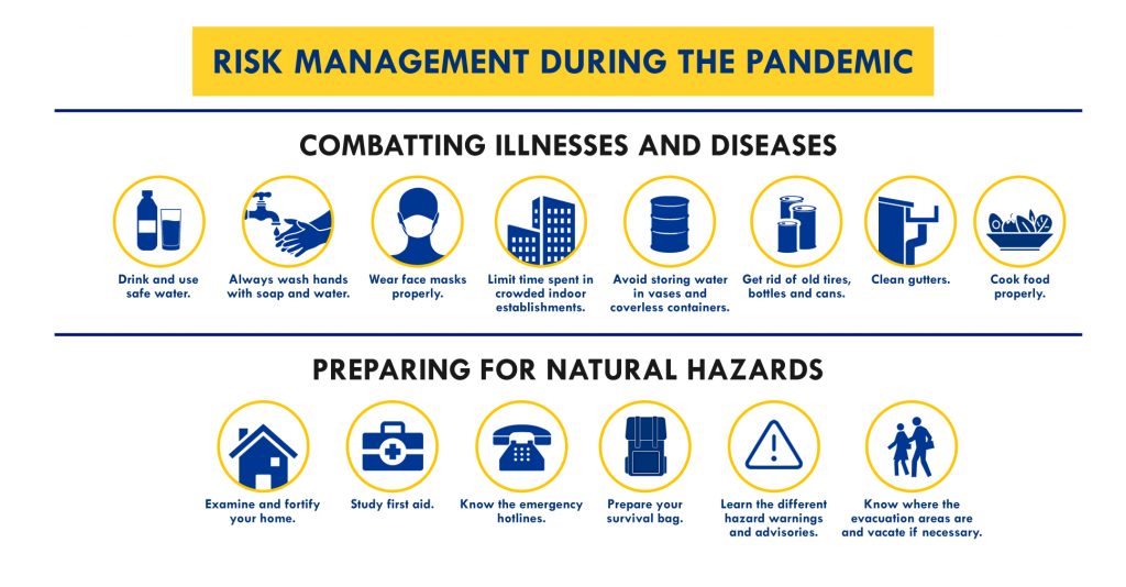 Graphics by Jearom Andre Martinez
This global crisis is not just about adapting to changes, but also preparing for complex emergencies. With inclusive, sustainable solutions, everyone—even the weakest—can be empowered to rise up to the challenges.
Assistance and additional reports from: Fritzjay Labiano, Relly Bernardo (Antipolo PIO), Vic Simoun Montoso, Mark Cashean Timbal (OCD), Lilia Malabuyoc (OCD)
Storm surges only entered the majority’s consciousness when Typhoon Yolanda devastated most of the Visayas, bringing 7-meter-high surges that claimed over 6,000 lives in Leyte and Samar in November 2013. The point cannot be emphasized enough: Storm surges can be fatal and we need to be prepared for them. Here’s a primer on one of the typhoon’s deadliest effects.
Top 5 Things You Need to Know about Storm Surges
1. A storm surge is not a tsunami. While a tsunami is a series of waves due to underwater seismic activities like earthquakes, a storm surge is the abnormal rise of seawater due to the low atmospheric pressure and strong winds brought about by a severe storm or typhoon. It may inundate low-lying coastal areas, resulting damage to properties, infrastructure and agriculture.
2. Storm surges can get pretty high. According to PAGASA, storm surges in our country may rise from an average of four to seven meters, which is equivalent to a 2-storey house, and may still intensify in the presence of high tide. Storm waves move as fast as seven meters per second, as fast as a golf ball driven off the tee, carrying small and large debris, which make them even more dangerous. When storm waves finally reach the ground, its speed becomes a little slower due to trees and other land structures.
3. Storm surges are deadlier in some areas than others. Studies say that storm surges may transpire in any seaboard affected by a severe storm, but the most devastating ones usually occur in our country’s southern and eastern seaboards. Eastern sections are typically flat and typhoon-frequented, making them prone to the surges.
4. Storm surges reoccur, especially in an archipelagic country like the Philippines. Eastern Visayas has been experiencing catastrophic storm surges for over a hundred years. On October 12, 1897 An Australian newspaper reported about a storm passing over Tacloban, the capital city of Leyte, claiming 7,000 lives. According to the Department of Science and Technology (DOST), the 1897 storm surge reached up to 7 meters, destroying churches and communities. In 1912, the front page of an American broadsheet featured a typhoon that injured and killed 15,000 people in Tacloban and Capiz. The DOST approximated the surge at four to nine meters tall.
5. More and more Filipinos face the risk of storm surges. The World Bank estimates more than 60% of our population live in coastal zones. In fact, the United Nations emphasized the swelling population of people residing in cyclone prone areas from 71.8 million in 1970 to 120.7 million in 2012. According to the National Geographic, the poor populace of the country has gradually moved to coastal islands, making a lot more people prone to the surges.
Now we know what storm surges are, how can we protect ourselves from them?
PREVENTIVE MEASURES AND SAFETY TIPS
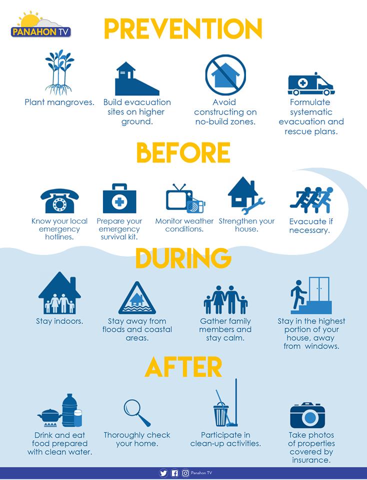
Plant trees. Plant mangroves and coconut trees along the shorelines, which may help shield the community from the waves brought by storm surges.
Avoid constructing on no-build zones. Know where the safe zones are by getting a hazard map from your barangay officers. A 40-kilometer buffer zone from the shore is advised in storm-surge prone areas.
Participate in community drills. Formulate systematic emergency, rehabilitation and relief distribution plans in your community. It is also essential to conduct a quarterly drill involving the children, youth, people with disability and senior citizens.
Plan with your family. Prepare a survival kit and a list of emergency hotlines. Discuss possible evacuation plans with your family and strengthen or fix your house if necessary.
Build evacuation sites on higher ground. Make sure that all evacuation areas are materially safe. Ensure safe routes and build directional signages going to the location.
Monitor weather conditions. Always be updated on news and announcements via radio, television and social media.
Stay Indoors. Stay in the highest portion of the house or building, away from the windows.
Evacuate if advised. Evacuate before the surge transpires, but if some members of the family have not yet arrived, call them or leave a note to inform them of your location. Switch off electricity, the waterline and gas tank. Make sure that all windows, cabinets, doors and gates are closed and locked before leaving.
Stay away from flooded areas and shorelines. Never attempt to pass a swollen river and avoid routes along the sea.
Follow the rules in evacuation sites. Do not litter, vandalize or destroy anything in the area. Observe proper hygiene to avoid illnesses and maintain peace and order in your area.
Here’s what else you need to do in the wake of a storm.
Sources: PAGASA-DOST, PROJECT DINA & Project NOAH