Just after midnight on August 17, 1976, a magnitude 8 earthquake shook the areas around Moro Gulf in Mindanao, including Cotabato City. But the disaster did not stop there; less than 5 minutes later, a tsunami as high as 9 meters roared and swallowed 700 kilometers of coastline. When the sea ebbed to its peaceful state, around 8,000 had died from the combined effects of the earthquake and tsunami, with the latter accounting for 85% of deaths and 95% of those missing and never found. The event, now known as the 1976 Moro Gulf Earthquake, is recognized as the deadliest earthquake that ever hit the country.
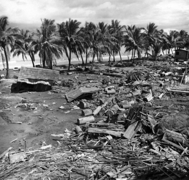 Devastation of the 1976 tsunami at Barangay Tibpuan in Lebak, Mindanao (Photo from Wikimedia Commons)
Almost two decades later on November 15, 1994, Mindoro was rocked by a magnitude 7.1 earthquake. Like what happened in Mindanao, majority of the 78 casualties of the Mindoro earthquake was due to the 8-meter high tsunami that occurred 5 minutes after the quake.
The truth is, though Filipinos are aware of devastating tsunami happening in other countries like Japan and Indonesia, they do not often associate these natural disasters in their homeland. But as past events indicate, deadly tsunami can occur locally. As Undersecretary of the Department of Science and Technology (DOST) for Disaster Risk Reduction-Climate Change Adaptation (DRR-CCA) and Officer-In-Charge of the Philippine Institute of Volcanology and Seismology (PHIVOLCS) put it, “Tsunami are very fast in the Philippines and we need to prepare for them.”
Tsunami 101
In observance of World Tsunami Awareness Day last November 5, PHIVOLCS organized an online press conference to spread the word about tsunami. Mostly generated by under-the-sea earthquakes, tsunami are characterized by a series of waves with heights of more than 5 meters. According to Solidum, such earthquakes can be triggered by underwater landslides, volcanic eruptions, and the more unlikely meteor impacts. These cause the seafloor to lift, causing the water it carries to rise.
There are two types of tsunami—the distant and local. Distant or far-field tsunami is generated outside the Philippines, mainly from countries bordering the Pacific Ocean like Chile, Alaska (U.S.) and Japan. With these events being monitored by The Pacific Tsunami Warning Center (PTWC), the Philippines has 1 to 24 hours of preparation before the tsunami’s arrival, depending on its origin.
But with local tsunami, lead time is cut down to a mere 2 to 10 minutes after the earthquake. “Preparedness is very important because rapid response is needed for locally-generated tsunami. The trenches are where the large earthquakes and tsunami can be generated, and we are only the country wherein trenches can be found on both sides. Hence, both sides of the country need to prepare for tsunami. Aside from that, the eastern side of the country faces the Pacific Ocean or the Pacific Ring of Fire where earthquakes and tsunami can also be generated,” said Solidum.
What PHIVOLCS is doing
Part of the Tsunami Risk Reduction Program of PHIVOLCS are the Tsunami Hazard Mapping and Modeling, and the Tsunami Hazard Risk Assessment, both of which aim to understand tsunami, manage their hazards and risks, and identify priority actions for response and recovery. To detect possible tsunami, PHIVOLCS set up its Monitoring and Detection Networks Development.
Aside from the 107 seismic stations that receive data for earthquakes and tsunami, there are also 29 real-time tide gauges all over the country. Through the hazards and risk-assessment software code REDAS, PHIVOLCS can evaluate potential earthquake hazards, create tsunami simulations, and predicting the number of affected people. “The total population exposed to tsunami would be close to 14 million,” said Solidum. “But they will not be affected at the same time. It would depend on where the tsunami would occur. In NCR, for example, the prone population would be around 2.4 million. And the next highest would be 1.6 million in Region VII, 1.2 million in Region VI— and in Region IXA, around 1 million.”
Meanwhile, HazardHunter Philippines, which is open for public use, can assess hazards depending on the user’s specific location. “HazardHunter can also give you a more detailed tsunami hazards assessment because it can provide you a map showing the different areas that will be affected by different tsunami heights. It is color coded, indicating areas prone to various tsunami heights.” Solidum appealed to the public to take advantage of the “Report a Disaster” website. Here, people can post pictures and videos of current risks and hazards in their areas, and describe disasters impacts, which can help the government’s risk and impact assessments.
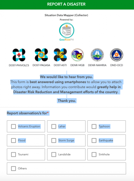 Screencap of “Report a Disaster” website
“In the Philippines, we use a simple tsunami information or warning scheme,” explained Solidum. “We will evacuate once the tsunami information is categorized as a tsunami warning. We expect a destructive tsunami of more than 1 meter and this would need immediate evacuation of coastal areas. Boats at sea are advised to say offshore — in deep waters.”
Shake, drop and roar
Because local tsunami can be very fast, people need to know its natural signs:
Shake – refers to a strong earthquake.
Drop – refers to the sea level receding fast.
Roar – refers to the unusual sound of the returning wave, which indicates a tsunami.
After an earthquake, Solidum recommends for people near the shore to immediately move to elevated ground inland, or take refuge in tall and strong buildings. “If they have not moved at all, once they hear the tsunami and there are unusual sounds, there might not be enough time. They really need to respond immediately,” warned Solidum.
PHIVOLCS also released tsunami safety and preparedness measures on their website:
- Do not stay in low-lying coastal areas after a felt earthquake. Move to higher grounds immediately.
2. If unusual sea conditions like rapid lowering of sea level are observed, immediately move toward high grounds.
3. Never go down the beach to watch for a tsunami. When you see the wave, you are too close to escape it.
4. During the retreat of sea level, interesting sights are often revealed. Fishes may be stranded on dry land thereby attracting people to collect them. Also sandbars and coral flats may be exposed. These scenes tempt people to flock to the shoreline thereby increasing the number of people at risk.
Solidum stressed the importance of community-based preparedness, built on planning and drills to create the following output:
- development of evacuation plans based on the hazard maps
- installation of different types of signage (signage for hazards, signage for the evacuation area, signage for the directions to go to the evacuation area)
- conducting of seminars and lectures
- drills
Tsunami preparedness during COVID-19
The devastation of several typhoons this year, coupled with the country’s location in the Pacific Ring of Fire, are proof that the Philippines is prone to various hazards. Because of the
COVID-19 pandemic, Solidum admitted that PHIVOLCS had to rethink their training methods. “Before, we actually go down to various coastal communities and conduct lectures in the evening, so that people who worked in the daytime can also attend. But the pandemic has enabled more people to listen because of the social media platform and our webinars. We’ve reached more people in terms of information campaign. But we hope that local government disaster managers will do the actual preparedness at the community level.”
Solidum noted that though COVID-19 continues to cause loss of lives and the disruption of public services, mobility and economic development, tsunami can create far more devastating impacts. “We will see the physical impacts through buildings, infrastructures, property, water supply pipes, electrical supply, communication system, roads, bridges, and ports. This is in addition to the physical impact on people because of the collapsing houses or the impact of the large volume of water. We have science, technology, and innovation from DOST that can help in preparedness and disaster risk reduction. We need to use it, but we need to share this information to the communities and the public,” he ended.
Watch the full press conference from PHIVOLCS.
Watch Panahon TV’s primer on tsunami.
In 2004, one of the deadliest tsunamis in world history hit the Indian Ocean.
It was a Sunday morning, right after Christmas Day, when a magnitude 9.1 underwater earthquake jolted the Sumatra Coast of Indonesia. The quake spawned tsunamis as high as 30 meters that swept through the shores of countries around the Indian Ocean, such as India, Indonesia, Sri Lanka and Thailand. The huge waves killed over 200,000 people.

This devastating event proves that tsunamis must not be taken lightly. To create awareness about their risks and preventive measures, the United Nations declared November 5 as World Tsunami Awareness Day.
WHAT IS A TSUNAMI?
Tsunami is a Japanese word from “tsu” which means harbor and “nami” which translates to wave. According to the Philippine Institute of Volcanology and Seismology (Phivolcs), a tsunami is a series of waves commonly generated by under-the-sea earthquakes, whose heights can be greater than 5 meters or 16.4 feet.

Tsunamis may occur when an earthquake is shallow-seated and strong enough to displace parts of the seabed and disturb the mass of water over it. They are erroneously called tidal waves and sometimes mistakenly associated with storm surges. Natural signs of approaching tsunami include: a felt earthquake, an unusual sea level change (sudden sea water retreat or rise), and a rumbling sound of approaching waves.

WARNING SIGNALS
In the Philippines, the 2004 Asian Tsunami greatly impacted the development of early warning signals in coastal communities. In 2012, the Cost-Effective Local Tsunami Early Warning System for Selected High-Risk Coastal Communities of the Philippines was first established in Albay and Pangasinan. The technology is basically made up of a platform with a 15-meter high pole. Two types of sensors are attached to this pole: one that notes the rise and fall of the sea level, and the PHIVOLCS-designed wet and dry sensors. The wet sensor detects post-earthquake receding water which may signal an impending tsunami, while the latter determines if water has already hit the pole.
Information generated by the system reaches local government units (LGU) in near real-time. In cases when an earthquake is strong enough to cause a tsunami, the LGU can sound off the warning siren to warn those living in coastal areas and give them enough time to prepare and flee their homes.
Apart from locally generated tsunamis, distant or far field tsunamis are also being monitored. This happens when an underwater earthquake occurs outside the Philippines or in the Pacific Ocean. Depending on the location, a distant tsunami has a longer lead time as compared to locally generated ones which can only take 2 to 20 minutes before the waves reach the shores of affected areas.
MOST-PRONE AREAS
The Philippines is located within the Pacific Ring of Fire, an area in the Pacific border where seismic activities occur, and is also surrounded by bodies of water. This makes us prone to tsunamis.

In December 2007, the Tsunami Hazard Maps were produced under the Department of Science and Technology- Grant-In-Aid Program (DOST-GIA) identifying the following areas that are most vulnerable to tsunamis:
LUZON
Region I- Ilocos Norte, Ilocos Sur, La Union, Pangasinan
Region II- Batanes, Cagayan, Isabela
Region III – Aurora, Bataan, Zambales
Region IV-A – Batangas, Cavite, Quezon
Region IV-B – Mindoro Island, Palawan
Region V – Albay, Camarines Norte, Camarines Sur, Catanduanes, Sorsogon
VISAYAS
Region VI – Aklan, Antique, Guimaras, Iloilo, Negros Occidental
Region VII – Bohol, Negros Oriental, Siquijor
Region VIII – Eastern Samar, Northern Samar, Leyte Island
MINDANAO
Region IX – Zamboanga City, Zamboanga del Norte, Zamboanga del Sur, Zamboanga Sibugay
Region X – Camiguin, Lanao del Norte
Region XI – Davao del Sur, Davao Oriental
Region XII – Sarangani, South Cotabato, Sultan Kudarat
Region XIII – Surigao del Norte, Surigao del Sur
ARMM – Basilan, Lanao del Sur, Maguindanao, Sulu, Tawi-Tawi
SAFETY MEASURES
Because tsunamis can occur anytime of the day, international humanitarian organization Red Cross laid out safety measures before, during and after a tsunami.
Before
– Discuss with your family what to do during a tsunami. This helps reduce fear, particularly among younger children.
– Check your workplace and your children’s schools and daycare centers to learn if they are in a tsunami hazard area or inundation zone. Learn about their evacuation plans, especially the designated spots where you can pick up your children.
– Plan evacuation routes from your home, school, workplace and other places you could be where tsunamis present a risk.
– If possible, try to pick evacuation areas 100 feet above sea level or 2 miles inland.
– If you cannot get that high or far, go as high or far as you can. You should be able to reach the highest ground possible on foot within 15 minutes.
– Practice your evacuation routes. Familiarity may save your life. Be able to follow your escape route at night and during inclement weather.
During
– Drop, cover, and hold on to protect yourself from the earthquake.
– When the shaking stops, gather members of your household and review your evacuation plan. A tsunami may be coming within minutes.
– Follow instructions issued by local authorities. Recommended evacuation routes may be different from the one you planned, or you may be advised to climb higher.
– Use a battery-powered radio to get updated emergency information.
– If you hear an official tsunami warning or detect signs of a tsunami, evacuate at once. A tsunami warning is issued when authorities are certain that a tsunami threat exists, and there may be little time to get out.
– Take your emergency preparedness kit. Having supplies will make you more comfortable during the evacuation.
– If you evacuate, take your animals with you. If it is not safe for you, it is not safe for them.
– Get to higher ground as far inland as possible. Watching a tsunami from the beach or cliffs could put you in grave danger.
– Avoid fallen power lines and stay away from buildings and bridges from which heavy objects might fall during an aftershock.
– Stay away until local officials tell you it is safe. A tsunami is a series of waves that may continue for hours. Do not assume that after one wave, the danger is over. The next wave may be larger than the first one.
After
– Let friends and family know you’re safe.
– If you have evacuated, return only when authorities say it is safe to do so.
– Continue listening to local news for updated information and instructions.
– If people around you are injured, practice CHECK, CALL, CARE. Check the scene to be sure it’s safe for you to approach; call for help; and if you are trained, provide first aid to those in need until emergency responders arrive.

Although earthquakes remain unpredictable, tsunamis can now be better foreseen through the use of technology. But this doesn’t give us an excuse to forego preparation. Remember that being prepared for disasters spells the difference between life and death.
REFERENCES:
http://www.dost.gov.ph/knowledge-resources/news/35-2012-news/213-dost-s-tsunami-warning-system-makes-coastal-communities-safer
http://www.phivolcs.dost.gov.ph/index.php?option=com_content&view=article&id=77&Itemid=129
http://www.phivolcs.dost.gov.ph/index.php?option=com_content&view=article&id=312&Itemid=500027
http://www.redcross.org/get-help/how-to-prepare-for-emergencies/types-of-emergencies/tsunami#Fact-vs-Fiction
http://www.sms-tsunami-warning.com/pages/tsunami-sumatra-2004
Earthquake Survival quite literally begins in your own home. To ensure safety against tremors, it’s important to assess your living space to know what types of repair and reinforcement it needs to be quake-resilient.
You can begin your home inspection by examining two major factors: its content and structure.
Securing House Contents
It is important to identify the items that can possibly move, break or fall when a quake jolts your house.

Things to remember:
1. Secure hanging fixtures on the wall and ceiling.
2. Strap down hazardous electrical components.
3. To prevent tipping, heavy and tall objects such as appliances and cabinets must be anchored or braced using a flexible fastener like a nylon strap and a hook.
4. Place the fragile, large and weighty objects on the lower shelves of cabinets.
5. Lock the cabinets if possible.
6. Rearrange large things including framed pictures and mirrors away from seats and beds to prevent injury to occupants when ground shaking occurs.
7. Ensure elastic connector on gas stoves or appliances.
8. Check the accessibility of fire exits.
9. Know when and how to shut off utility lines.
Checking Home Integrity
According to the Metro Manila Earthquake Reduction Study (MMEIRS), 38.3% of residential buildings in Mega Manila might be damaged when the Valley Fault System moves. 339,800 of them will be partly disrupted while 168,300 will be heavily dented. Unlike other hazards, quakes can transpire anytime without warning, bringing secondary dangers such as fire, liquefaction and ground rupture among others.
This study led PHIVOLCS in coming up with a checklist that homeowners can use in assessing how their Concrete Hollow Block (CHB) house will fare in the event of a strong quake. This checklist is applicable to 1- and 2-storey houses, and a must for houses built before 1992 when the earthquake resistance standards were introduced to the Building Code.

Evaluation will be based from the tally of scores from the 12-point checklist:
0 – 7: Assessment is disturbing and needs consultation with experts as soon as possible.
8 – 10: House requires strengthening and expert consultation.
11 – 12: Seems safe but needs confirmation from experts.
PHIVOLCS recommends consulting with a licensed architect or civil engineer and a licensed contractor for official assessments. Aside from further renovation, checking your foundation for cracks must be done whenever there are interferences— natural or manmade— that happened in your area.
Building a Quake Resilient House
1. Have a licensed civil engineer or architect supervise the building of your house to ensure compliance to Building and Structural Codes.
2. Construct a regular-shaped house on a rock or stiff soil. Avoid building structures on muddy and reclaimed lands.
3. Use 6-inch thick concrete hollow blocks.
4. Vertical bars should be 100 mms. in diameter and must only have a 40-cm gap in between.
5. Horizontal bars must be 10 mms. thick and spaced between 3 layers of CHB.
6. Walls more than 3 meters wide have to be reinforced.
7. May need to add more foundation.
8. Use light materials on gable walls. Gable wall is the triangular area that connects the roof and the wall. Or better yet, build a flat roof house.

http://goo.gl/ddkxm2
Exactly four years ago, the people of Northeast Japan experienced the darkest and longest six minutes of their lives as a 9.0 magnitude earthquake shook their homes, setting off a chain of catastrophic events that killed 15,703 people and destroyed $300 billion worth of properties.
Let us remember the key events that unfolded on those fateful days, which began on March 11, 2011:
March 11, Friday, 2:46 PM One of the most powerful earthquakes shook Northeast Japan, prompting the Pacific Tsunami Warning Center to issue a tsunami warning from Japan to the U.S. west coast. The tsunami alert included more than 50 countries, including the Philippines.
Just within an hour after the quake, a tsunami with an estimated height of 30 feet pounded over Japan’s coastal areas. Residential establishments, commercial buildings, and even cars and trains were washed away. Vital infrastructures, such as bridges, roads, and communication towers were also destroyed. Dead people were scattered on the streets.
8:15 PM The tsunami that ensued after the quake posed a threat to 54 nuclear power plants across Japan, urging the Japanese Government to declare an emergency situation for the power plants near Sendai, 180 miles from Tokyo.
10:29 PM The cooling system of the Fukisihima nuclear plant ceased operating, spreading fear of radiation leaks. Thousands of people living within the mile-and-a-half radius of the plant were ordered to evacuate.
March 12, Saturday, 2:06 AM The radiation level in the Fukishima nuclear plant began to rise. In less than an hour, the government confirmed a radiation leak. An explosion occurred in a building housing one of the plant’s reactors.
March 13, Sunday, Energy rationing had to be implemented due to the shutting down of nuclear power stations. Millions of residents were without power and water.

http://goo.gl/ddkxm2
March 14, Monday, A second explosion occurred at the Fukishima nuclear power plant.
In a report dated February 10, 2015, CNN.com reported 15,890 confirmed deaths due to the earthquake and its related incidents.
In another report dated March 9, 2015, USA Today stated that radiation levels remain as much as 10 times above normal, resulting to nearly a quarter-million displaced Japanese. Hundreds of square miles forest, farmlands and settlement remain uninhabitable.
Recovery Efforts
The wise Confucius once said that “It does not matter how slowly you go as long as you do not stop”, a saying that’s synonymous to Japan’s current efforts.

http://goo.gl/ddkxm2
Despite the slow pace of recovery, Japan continues to strive harder, seen with the construction of 70 new sea walls (90-meters wide, 15-meters high) that started in Kesennuma in the Miyagi Prefecture. This was authorized by the central government to protect the northeastern coastline.
From 40%, the operation of fish processing businesses in five (5) hardest-hit prefectures has doubled to 80%.
Considerable progress has also been reported in areas affected by radiation. Clean-up efforts have reduced the levels of radioactivity around the Fukushima nuclear power plant. Hospitals, nursery homes and some vital institutions are either finished or nearing completion according to Japanese Red Cross.
The 2011 Great East Japan Earthquake reminded us that even a highly developed country such as Japan, with all its advanced technology, was still no match against nature’s fury.
Nevertheless, four years after the disaster, the Japanese people’s discipline and tenacity prevail as they continue to recover and rebuild their communities.
The northeast monsoon is still the dominant weather system inside the PH boundary.
Today, the islands of Batanes, Calayan and Babuyan will have partly cloudy skies with light precipitation. Meanwhile the rest of the country including Metro Manila will have favorable weather conditions, however PAGASA suggests continuous monitoring as isolated rains and thunderstorms are expected to happen within the day.
The state weather bureau is also monitoring the progress of El Nino. According to PAGASA Meteorologist Buddy Javier, the National Oceanic and Atmospheric Administration has a reported weak El Nino. However, the full details regarding the matter will be discussed today at the conference to be held at PAGASA.

March 11, 2011: The Great East Japan Quake and Tsunami
Exactly four years ago, the people of Northeast Japan experienced the darkest and longest six minutes of their lives as a 9.0 magnitude earthquake shook their homes, setting off a chain of catastrophic events that killed 15,703 people and destroyed $300 billion worth of properties.
Let us remember the key events that unfolded on those fateful days, which began on March 11, 2011.

Because life is unpredictable, getting caught in challenging situations is a definite possibility.
One easy way of being prepared is leveling up your EDC or “Everyday Carry,” a collection of small items or gadgets found in your everyday bag, which you can bring wherever you go to ensure your safety and survival. EDC may be customized, depending on your personal needs and budget, but there are basic items that should always be part of it.
Umbrella
No matter what the season—wet or dry—bringing an umbrella is always a wise decision. It protects you, not only from unpredictable rains, but also from the harsh rays of the sun. According to the DOH or Department of Health, overexposure to UV (ultraviolet) rays may lead to skin cancer.
Flashlight
Darkness is crime and accident’s best friend. The easy solution to power failures and navigating your way around light-deprived areas is a handy, light-weight flashlight. Some flashlights double as keychains, which you can easily hook into your bag’s zipper. If your flashlight is battery-operated, invest in rechargable batteries; they are environment-friendly and come out cheaper in the long run. The Philippine Red Cross recommends using flashlights with LED or Light Emitting Diode bulbs, which use less power, and do not burn out.
Whistle
Some flashlights are equipped with built-in whistles, which can be used to call attention when you need assistance. Shouting for help takes a toll on your energy reserves and vocal cords.
First Aid Kit
Aside from the usual wound-tending agents such as alcohol, gauze pads, adhesive tape, cotton and piovine-iodine solutions, it’s best to carry medication for common illnesses such as cough, colds, headaches or stomach pains. If you have specific illnesses that require maintenance drugs, keep these meds with you at all times.
Pen and Paper
Taking down notes is one of the simplest things we can do to get important information whether it’s a name, phone number or an address. These can also be used for leaving messages. Here’s an additional tip: You can wrap your pen with thread or duct tape which can also come in handy during emergencies.
Small Scissors or Survival Knife
You can use this to cut ropes, cloth and other light materials. It can also be an effective tool for self-defense. Just make sure that it’s kept in a well-padded container inside your bag to avoid injury.
Fire starters
Since the beginning of time, fire has always been necessary for survival, used for cooking, producing heat, and light. The PRC suggests carrying at least three different items that produce fire: lighter, matches and a magnesium striker. Lighters can turn out to be defective and may run out of fuel. Meanwhile, matches can be difficult to use in windy weather.
Safety pins
These light-weight items can be used to repair or adjust clothes or gear. A safety pin can also be useful in putting keys together, replacing your zipper puller or be an alternative fishing hook.
Crackers/Candies
Food is very important especially when you travel for long hours. Keeping crackers or candies in your bag is one of the easiest ways to satisfy your hunger or diminish dizziness.
Water
Water does not only serve as a thirst-quencher to keep your body hydrated but it can also be used in cleaning wounds.
What’s your EDC? Post it in our comments section and let’s talk about it.
Sources: Department of Health, Philippine Red Cross
Related links: Emergency Checklist, Emergency Hotlines
Amor Larrosa is a weather reporter of Panahon.TV, aired daily at 5:00AM on the People’s Television (PTV). She goes by the title of Weather Lover and believes that “Ang taong handa at mahinahon, kayang lagpasan ang hamon ng panahon.” Follow her on Twitter.
For up-to-the-minute weather updates, follow Panahon TV on Facebook and Twitter.