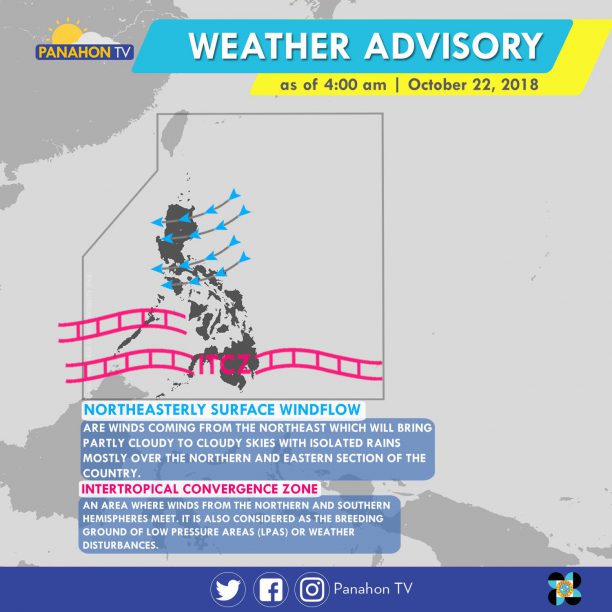
The Northeasterly Surface Windflow continues to affect Luzon, bringing cloudy skies with scattered rain showers and thunderstorms in Quezon, Bicol Region and the rest of MIMAROPA. Meanwhile, cloudy skies with scattered rain showers and thunderstorms are expected in Mindanao and Palawan caused by the Intertropical Convergence Zone (ITCZ), or the imaginary where winds from Northern and Southern Hemisphere meet. Metro Manila and the rest of the country will have partly cloudy to cloudy skies with isolated rain showers.
According to PAGASA Weather Forecaster Meno Mendoza, a Tropical Storm with international name “Yutu” was spotted outside the Philippine Area of Responsibility (PAR) 3,375 km east of Mindanao. It is expected to move northward, and will not enter PAR. He also added that cold air brought by the Amihan or Northeast Monsoon will be felt in the last week of October.
No gale warning is issued today.
As of 3:00 a.m., Severe Tropical Storm Trami was last spotted 1,580 kilometers east of Central Luzon (outside PAR). With maximum sustained winds of 100 kph (kilometers per hour) and gustiness of up to 120 kph, it moves west-northwest at 20 kph. Later this afternoon, it is expected to enter the Philippine Area of Responsibility (PAR).
Meanwhile, the Intertropical Convergence Zone (ITCZ) still affects Southern Luzon, Visayas and Mindanao. It brings cloudy skies with scattered rain showers and thunderstorms in Visayas, Mindanao and Palawan. Meanwhile, partly cloudy to cloudy skies with isolated rain showers are expected in Metro Manila and the rest of Luzon.
According to PAGASA Weather Forecaster Meno Mendoza, the Severe Tropical Storm is expected to enter PAR later this afternoon, making it the country’s 16thTropical Cyclone of the year. Once this happens, it will be named Typhoon Paeng. If it remains its track, it will affect the northern and eastern sections of Northern Luzon.
No gale warning was issued today.
Tropical Storm Egay has maintained its strength while moving closer towards Northern Luzon. At 7 AM today, the center of TS Egay was located at 340 kilometers east of Baler, Aurora with maximum sustained winds of 85 kph near the center and gustiness of 100 kph as it continues to move west northwest at 10 kph.
State Meteorologist Buddy Javier said that TS Egay is expected to intensify, but will not reach typhoon category. The said weather disturbance is forecast to exit the Philippine Area of Responsibility (PAR) on Thursday, July 9, 2015.
18 Areas now under Public Storm Warning Signals

Areas under signal no. 2 will experience stormy weather with 24 hours lead time. Rains and gusty winds are expected over the Cordillera Administrative Region, Ilocos provinces, Nueva Vizcaya, Nueva Ecija and Cagayan, including Babuyan and Calayan Group of Islands.
Metro Manila, CALABARZON, MIMAROPA, and Bicol Region will have cloudy skies with moderate to occasionally heavy rains and thunderstorms. Residents are advised on the possibilities of landslides and flashfloods. Light to moderate rain showers and thunderstorms will be experienced over Visayas, Zamboanga Peninsula and the rest of Luzon. Fair weather will prevail over the rest of Mindanao, apart from isolated rains and thunderstorms.
Meanwhile, Tropical Storm Chan-Hom is expected to enter PAR on Wednesday July 8, 2015. Javier said, Chan-Hom is forecast not to make any landfall; however it will enhance the southwest monsoon that will bring rain showers mostly in the western section of the country.

The Ridge of High Pressure Area continues to affect Luzon. This weather system is associated with fair weather conditions and high temperatures.
Today, the Philippines will experience partly cloudy to cloudy skies with isolated rain showers or thunderstorms mostly in the afternoon or evening.
Temperatures may reach up to 35 degrees Celsius with the heat index forecast showing 40.2 degrees Celsius in Metro Manila.

To counter the heat while looking your best, wearing light-weight and light colored clothing is recommended. Sunglasses don’t only look trendy; they also protect your eyes from the glare. Umbrellas with bright colors help shade you from the sun’s rays while giving off happy summer vibes.
In other news, PAGASA releases the revised classification of tropical cyclones effective May 01, 2015.

Accordingly, the public storm warning signal system of the agency was also modified.


The tropical storm with international name “Noul” continues to intensify as it slowly approaches the boundary. At 4:00 AM today, it was estimated at 1,495 kilometers east of Mindanao, packing winds of 85 kilometers per hour and gustiness of up to 100 kilometers per hour. Moving west-northwest at 9 kilometers per hour, it will possibly enter the Philippine Area of Responsibility (PAR) by Thursday.
PAGASA Weather Forecaster Glaiza Escullar said Noul is expected to move closer to the eastern section of Luzon on Saturday morning, bringing rains and occasional gusty winds over the Bicol Region. Meanwhile in the afternoon, stormy weather will then occur in Marinduque, Rizal, Laguna and Quezon Province. Metro Manila, Bulacan, Cavite, Batangas and Mindoro will have cloudy skies with rain showers and isolated thunderstorms.
By Sunday, Metro Manila, CALABARZON, Camarines Provinces, Central Luzon and the provinces of Quirino, Nueva Vizcaya and Pangasinan will experience stormy weather as Noul (Dodong) is expected to cross the Luzon area. PAGASA’s weekly weather outlook also shows that rains with occasional gusty winds will occur over the Bicol Region,and Northern and Central Luzon while MIMAROPA will have cloudy skies with light to moderate rains and isolated thunderstorms. The rest of the country will experience generally fair weather aside from the chances of isolated rain showers or thunderstorms mostly in the afternoon or evening.
However, Escullar clarified that this is just an outlook so changes may still occur. Noul could still recurve northward and change course in the next hours. All are advised to monitor updates from the weather bureau.
As of now, the said tropical cyclone does not have any effect yet on the country. Easterlies will prevail, bringing warm and humid weather in most parts of the country. Most parts of the archipelago will experience partly cloudy to cloudy skies with isolated rain showers or thunderstorms.

Tropical Storm Bavi is expected to enter the Philippine Area of Responsibility (PAR) Tuesday morning and will then be named Betty, State Meteorologist Manny Mendoza said.
Estimated at 2,100 kms east of the Bicol Region this morning, Bavi packs maximum sustained winds of 75 kph and gustiness of up to 90 kph. The cyclone moves in a west southwest direction at 35 kph.
Mendoza states that the storm has a higher chance of weakening into tropical depression category before dissipating in the following days.

Meanwhile, the ridge of high pressure area affects Northern Luzon, bringing a warm weather condition today.
Based on PAGASA’s latest weather forecast, the whole archipelago will experience partly cloudy to cloudy skies with possible isolated cases of rain showers or thunderstorms.

Moving in a west northwest direction at 25 kilometers per hour, a tropical storm with international name “Bavi” is now being monitored by PAGASA. According to Weather Forecaster Gener Quitlong, as of 8:00AM today, it was located at approximately 3,870 kilometers east of Mindanao.
“Bavi” is still too far to affect the country but if it maintains its speed and direction, it is expected to enter our boundary by Tuesday evening or Wednesday morning next week. All are advised to monitor updates and further development.

Meanwhile, compared to yesterday, the northeast monsoon or amihan has slightly weakened. It will affect Northern and Central Luzon, bringing cloudy skies with light rains over Cagayan Valley, the Cordillera Administrative Region and the province of Aurora. Metro Manila and the rest of the country will have generally fair weather aside from possible isolated rain showers or thunderstorms mostly in the afternoon or evening.

As amihan weakens, coastal waters throughout the archipelago will have slight to moderate conditions. Though gale warning was already lifted, all fishing boats and other small sea craft are still advised to be cautious in venturing out into the sea.
The presence of the prevailing amihan also affected the temperatures in Luzon but these were not as low as the previous records. Here are the lowest temperatures recorded in the Philippines yesterday, March 12, 2015:

Tropical storm Amang made its first landfall at 3:00 PM yesterday. At 7:00 AM today, it was estimated at 60 kilometers north northeast of Sorsogon City or 25 kilometers southwest of Virac, Catanduanes packing winds of 85 kilometers per hour and gustiness of up to 100 kilometers per hour. At a speed of 15 kilometers per hour, it moves in a northwest direction.
Public Storm Warning Signals are still up overs some areas of Luzon and Visayas.
Residents in low-lying and mountainous areas under the storm signals are alerted against possible flashfloods and landslides. Occurrence of ocean waves that may reach 6.5 meters are still possible within the 350 kilometer-diameter of Amang.

Bicol Region and the provinces of Samar, Quezon and Aurora will experience stormy weather. Metro Manila, the rest of CALABARZON and the provinces of Ifugao, Nueva Vizcaya, Bulacan, Quirino, Nueva Ecija, Oriental Mindoro, Marinduque at Romblon will have rains with gusty winds. Western Visayas and the province of Leyte will be cloudy with light to moderate rains.
The rest of Visayas and Mindanao will have partly cloudy to cloudy skies with a chance of thunderstorms while the rest of Luzon will be cloudy with light rains brought by the northeast monsoon or amihan.
Meanwhile, sea travel for fishing boats and other small seacraft is still risky on the seaboards of Luzon, Visayas and the eastern seaboard of Mindanao.
Papal Visit Day 4 Weather Forecast
At 10:00 AM today, the center of tropical storm “Amang” was estimated at 560 kilometers east of Borongan City, Eastern Samar with maximum sustained winds of 75 kilometers per hour and gustiness of up to 90 kilometers per hour. If Amang continues to move westward at 15 kilometers per hour, it is expected to make landfall over Northern Samar tomorrow evening.
As Amang moves closer to Visayas, some areas were put under Public Storm Warning Signal Number 1.

Amang is expected to bring estimated rainfall ranging from 7.5 to 20 millimeters per hour (heavy to intense) within its 300-kilometer diameter. Those who are residing in low-lying and mountainous areas under these storm signals are alerted against possible flash floods and landslides. Occurrence of ocean waves that may reach up to 6.5 meters are also possible.
PAGASA Weather Forecaster Aldczar Aurelio explained that the presence of two high pressure areas are influencing the movement of the tropical storm. However, there is still a chance for it to re-curve only if the high pressure area in the upper right will give way. As of now, Amang has a slim chance of intensifying into a typhoon. Continuous monitoring will be done in the following hours.
For today, occasional rains with gusty winds will be experienced over Bicol Region and Eastern Visayas. Cloudy skies with light to moderate rains are expected over Central Visayas and CARAGA. The rest of Visayas and Mindanao will be partly cloudy to cloudy with isolated rains and possible thunderstorms.
Meanwhile due to the northeast monsoon or amihan, Cagayan Valley and Cordillera will have cloudy skies with light rains. Metro Manila and the rest of Luzon will be partly cloudy to cloudy with isolated light rains.
Due to the winds associated with the prevailing amihan and Amang, sea travel remains risky over the seaboards of Northern and Central Luzon, and the eastern seaboards of Southern Luzon, Visayas and Mindanao.

Weather outlook for Papal Visit Days 3 and 4
Today is the 2nd day of Pope Francis in the Philippines. Based on his itinerary, tomorrow, January 17, he will travel from Manila to Tacloban to meet with Yolanda survivors. According to PAGASA Weather Forecaster Aldczar Aurelio, Tacloban will experience occasional rains with gusty winds.
Meanwhile, Pope Francis is expected to return back to Manila on January 18 to meet the youth and conduct a holy mass in Quirino Grandstand. Aurelio said we are expecting cloudy skies with light to moderate rains by Sunday.