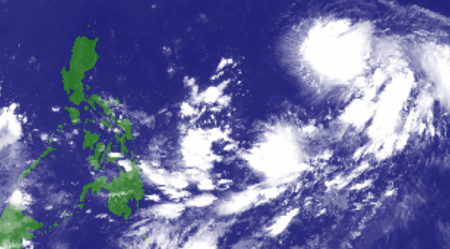
As of 3:00 a.m. today, a Tropical Depression was spotted at 2,015 kilometers east of Southern Luzon. According to PAGASA Weather Forecaster Loriedin Dela Cruz, though the Tropical Depression is not expected to make landfall, it may enter the Philippine Area of Responsibility (PAR) tomorrow afternoon (September 23). Once it becomes a Tropical Storm, it will be called by its local name, “Paeng”.
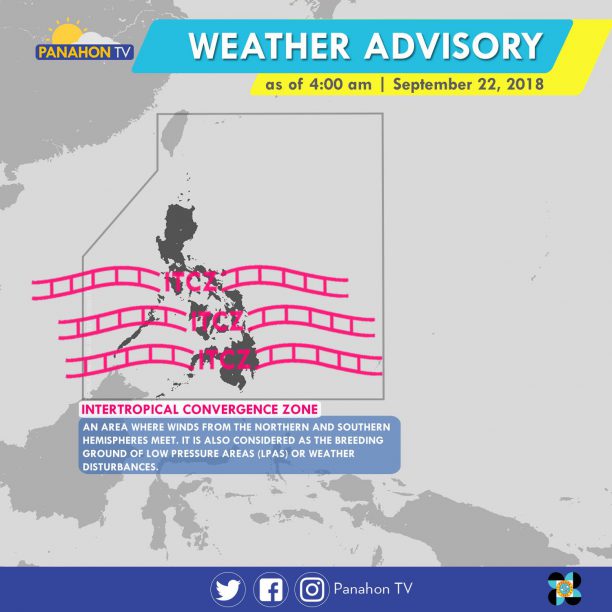
Meanwhile, the Intertropical Convergence Zone (ITCZ) continues to affect Southern Luzon, Visayas and Mindanao. This weather system brings cloudy skies with scattered rain showers and thunderstorms in MIMAROPA, Visayas, Zamboanga Peninsula, Northern Mindanao and CARAGA.
Partly cloudy to cloudy skies with isolated rain showers will be experienced in Metro Manila and the rest of the country.
A Tropical Depression is brewing outside the Philippine Area of Responsibility (PAR).
According to PAGASA weather forecaster Sheilla Reyes, two Low Pressure Areas (LPA) are still being monitored. The one inside PAR, spotted at 420 kilometers (km) east of Hinatuan, Surigao del Sur, is expected to dissipate. However, the other LPA outside PAR may intensify into a Tropical Depression. Reyes said that the LPA was spotted at 1,975 km. east of Mindanao. Based on PAGASA’s analysis, it may develop into a Tropical Depression tomorrow and will be named ‘Basyang’, the country’s second tropical cyclone this 2018. It is forecast to enter PAR on Sunday or Monday.

On Monday evening or early Tuesday, it may hit Northern Mindanao and the southern part of Visayas before heading toward Palawan on Wednesday, February 14. PAGASA is not ruling out the possibility of the cyclone intensifying into a Tropical Storm (a cyclone with winds between 62 to 88 kilometers per hour) before landfall.
Although two weather disturbances surround the country, the Northeast Monsoon remains the dominant weather system. It will bring cloudy skies with scattered rains in the Cagayan Valley Region and Cordillera Administrative Region, while causing partly cloudy to cloudy skies with isolated rains in Ilocos Region. In the rest of the country including Metro Manila, partly cloudy to cloudy skies, or generally fair weather with isolated rain showers will be experienced.
With the surge of Amihan, gale warning is still in effect in the northern and eastern seaboards of Northern Luzon. These include coasts of Batanes, the Babuyan Group of Islands, Ilocos Norte, Cagayan and Isabela. Fishing boats and other small seacraft are prohibited from venturing, while larger sea vessels are alerted against rough to very rough seas.
In a weather bulletin issued at 11:00 AM today, PAGASA announced that Tropical Depression “Urduja” has further weakened after crossing Palawan. It has made its sixth landfall in Taytay, Palawan earlier this morning. Prior to this, it traversed other portions of Southern Luzon and Visayas. Below is the chronology of landfall activities:
– San Policarpio, Eastern Samar
December 16, 2017 (1:30 PM)
– Mobo, Masbate
December 17, 2017 (10:00 AM)
– Sibuyan Island, Romblon
December 17, 2017 (12:00 PM)
– Malay, Aklan
December 17, 2107 (6:00 PM)
– Cuyo Island, Palawan
December 17, 2017 (11:00 PM)
The center or the Tropical Depression was last spotted at 90 kilometers (km) north-northwest of Puerto Princesa City, Palawan with maximum winds of up to 45 kph and gustiness of up to 60 kph. Moving west at 18 kph, it is expected to exit the Philippine Area of Responsibility (PAR) tomorrow morning or afternoon.
Signal Number 1 remains hoisted in Palawan, where winds of 30 to 60 kph are expected in the next 36 hours. Residents are advised to prepare for rains with gusty winds and are alerted against flash floods and landslides.
Meanwhile, due to the Tail-End of a cold front, CALABARZON (Cavite, Laguna, Batangas, Rizal and Quezon), Bicol Region and the provinces of Aurora, Mindoro, Marinduque and Romblon will experience cloudy skies with scattered rain showers and thunderstorms.
The Northeast Monsoon, locally known as Hanging Amihan, also prevails and will continue to bring cooler weather in Metro Manila and the rest of Luzon. However, along with the cold weather are cloudy skies with scattered rains. Visayas and Mindanao can expect partly cloudy to cloudy skies with isolated rain showers or thunderstorms.
Gale warning is up in the seaboards of Northern and Central Luzon, which include Batanes, Calayan, Babuyan, Cagayan, Ilocos province, Isabela, La Union, Pangasinan, Aurora, Zambales and Bataan. The same warning is in effect in the western and eastern seaboards of Southern Luzon and the eastern seaboard of Visayas. These include Palawan, Occidental Mindoro, western coast of Batangas and of Cavite, the northern and eastern coasts of Camarines provinces, Catanduanes, as well as the eastern coasts of Albay, Sorsogon, Quezon, Polillo Island, Northern Samar and Eastern Samar. Fishing boats and other small seacraft are prohibited from sailing due to rough to very rough sea conditions.
Meanwhile, the Tropical Depression outside the PAR has weakened into a Low Pressure Area (LPA) and was last located at 1,500 km east of Mindanao. PAGASA Weather Forecaster Robert “Obet” Badrina said it may still re-intensify into a cyclone and could still enter the PAR within the week. The weather bureau reminds the public, including disaster risk reduction and management offices, to keep monitoring updates.


The Low Pressure Area (LPA) southeast of Puerto Princesa City, Palawan has developed into a Tropical Depression and was given the local name #TinoPH.

At 10:00 AM today, the Tropical Depression was located at 245 kilometers east-southeast of Puerto Princesa City, Palawan. It has maximum winds of 55 kilometers per hour (kph) with gustiness of 80 kph, moving in a west-northwest direction at a speed of 28 kph. It is expected to exit the Philippine Area of Responsibility tomorrow morning.

This weather disturbance is expected to make landfall in Southern Palawan this afternoon, between 4:00 PM to 6:00 PM. Tropical Cyclone Warning Signal Number 1 was hoisted in the said province.

Meanwhile, residents of MIMAROPA (Mindoro, Marinduque, Romblon and Palawan), the Bicol Region, Eastern Visayas, Caraga and Panay Island are alerted against possible flash floods and landslides. Metro Manila, CALABARZON (Cavite, Laguna, Batangas, Rizal and Quezon), and the province of Aurora will experience cloudy skies with light to moderate rains and isolated thunderstorms.
Sea travel is risky in the seaboards of Palawan due to moderate to rough seas brought by Tropical Depression #TinoPH.
Tropical Depression “Maring” dumped rainS all over Luzon on Tuesday. This caused flooding in major roads, stranding commuters, and prompted suspension classes and work in government offices and courts.

Photo by: Edgardo Olavidez Jr.

Photo by: Paul Arada

Photo by: Las Piñas Underground

Photo by: Norabell Yapana Lim

Photo by: RAHA Volunteers Fire Department

Photo by: Emerson Resurrection

Photo by: Vhanny Violanta

Photo by: April Diane Manguit Restrivera

Photo by: Marquis Villanuev

Photo by: PJ Malolos Cabrera

Location: Sto. Tomas, Batangas at 11:30pm Sept. 11

Photo Credit: Francisco Macabuhay Delgado
8am
As we expect Tropical Depression (TD) Nona to exit the Philippine Area of Responsibility (PAR) this weekend, TD Onyok crossed the PAR line yesterday afternoon. According to PAGASA Weather Forecaster Buddy Javier, it is forecast to make its landfall tomorrow afternoon or in the evening in the Caraga region. And as of 4:00 AM today, Onyok was last located at 700 kms. east-northeast of Mati City, Davao Oriental, with maximum sustained winds of 55 kph. It moves westward at 15 kph.

Meanwhile, Nona remains stationary at its location of 60 kms. east of Iba, Zambales. Javier adds that it may continuously weaken into a Low Pressure Area (LPA) in the next 24 hours. Public Storm Warning Signal number 1 is still raised over Pangasinan and Zambales.

With the two (2) tropical cyclones inside our boundary, rains with gusty winds prevail in the areas with Public Storm Warning Signal Number 1. Meanwhile, moderate to occasionally heavy rains and isolated thunderstorms are expected over Cagayn Valley, Cordillera, and the rest of Central Luzon and Ilocos Region, possibly triggering flash floods and landslides. Light to moderate rains are at expected over Metro Manila, the rest of Luzon, Caraga and Davao Region. Fair weather conditions will be experienced in the rest of the archipelago.

Gale warning was raised in the seaboards of Northern Luzon, and the western and eastern seaboards of Central and Southern Luzon. Because of the rough to very rough sea conditions, fisher folk and those with small seacraft are advised to avoid venturing into the said seaboards.

The Ridge of High Pressure Area continues to affect Luzon. This weather system is associated with fair weather conditions and high temperatures.
Today, the Philippines will experience partly cloudy to cloudy skies with isolated rain showers or thunderstorms mostly in the afternoon or evening.
Temperatures may reach up to 35 degrees Celsius with the heat index forecast showing 40.2 degrees Celsius in Metro Manila.

To counter the heat while looking your best, wearing light-weight and light colored clothing is recommended. Sunglasses don’t only look trendy; they also protect your eyes from the glare. Umbrellas with bright colors help shade you from the sun’s rays while giving off happy summer vibes.
In other news, PAGASA releases the revised classification of tropical cyclones effective May 01, 2015.

Accordingly, the public storm warning signal system of the agency was also modified.

By: Jesy Basco

Tropical Storm Chedeng has weakened into a low pressure area (LPA). The state weather bureau PAGASA has issued its final severe weather bulletin at 5 pm today, stating the LPA was located 60 kilometers southeast of Laoag City or in the vicinity of Kabugao, Apayao. According to PAGASA Weather Forecaster Gener Quitlong, the said weather disturbance is forecast to exit the landmass of Ilocos Norte tomorrow early morning and exit PAR by Tuesday. The LPA has a slim chance to intensify into tropical cyclone, Quitlong added.
All Public Storm Warning Signals are now lifted.
Due to its extended cloud bonds, light to moderate rains are expected in the Northern and Central Luzon including Cagayan Valley, Cordillera and Ilocos.
Small sea vessels are still alerted against moderate to rough seas over the seaboards of Northern Luzon, including the coastal areas of Batanes, Calayan, Babuyan, Ilocos Norte, Cagayan, Isabela, Ilocos Sur, La Union and Pangasinan.
Meanwhile, Metro Manila and the rest of the country will experience generally good weather aside from partly cloudy to cloudy skies with isolated rain showers and thunderstorms.
Another tropical cyclone
Another tropical cyclone is being monitored by PAGASA. Located at 2,700 kilometers east of Mindanao, tropical depression “Haishen” (international name) has a maximum sustained winds of 55 kph.
Quitlong said, TD “Haishen” is forecast to dissipate within 24 to 48 hours and brings no threat to any part of the country.
UPDATED AS OF 8:56AM (PST) — Originally 10 kph shy of being a Super Typhoon by PAGASA standards, Chedeng further weakened to tropical depression category this morning.
From the original 215 kph wind strength, it now packs only 55 kph near the center, allowing PAGASA to lower Public Storm Warning Signals (PSWS) except in the provinces of Isabela, Aurora, Quirino and Polillo Island, which are still under PSWS #1 today. These areas will have occasional rains with gusty winds within at least 36 hours.

Aside from being downgraded into a tropical depression, Chedeng also remained stationary. In fact, PAGASA states it is expected to remain almost stationary in the next 6 hours.
State Meteorologist Samuel Duran says as of 8 o’clock this morning, Chedeng has already made landfall in the vicinity of Dinapigue, Isable. With unfavorable conditions, now including land interaction, Chedeng has a high chance of weakening into a Low Pressure Area instead of hitting the land.
The constant factors of its continued weakening and becoming almost stationary include two High Pressure Areas north and west of the country, as well as a strong vertical wind shear. These made the cyclone unable to retain and gain moisture to sustain its strength and continue its projected track.
With this, the threat of storm surge is removed. However, gale warning is up over the northern seaboards of Luzon. and the eastern seaboards of Northern and Southern Luzon as Chedeng will still generate rough to very rough sea conditions. Fisherfolk, especially in small seacraft, are then advised not to venture out due to risky sea travel especially.
EASTER SUNDAY WEATHER
Today, areas under PSWS #1 will experience occasional rains and gusty winds due to Chedeng. The Bicol Region and Samar provinces can expect a rainy Sunday as Metro Manila and the remaining parts of the country may experience a fair weather condition.
Everyone is advised to bring umbrellas for sun protection and possible thunderstorms later in the day. Also, continue monitoring weather updates thru Panahon TV social media accounts.
