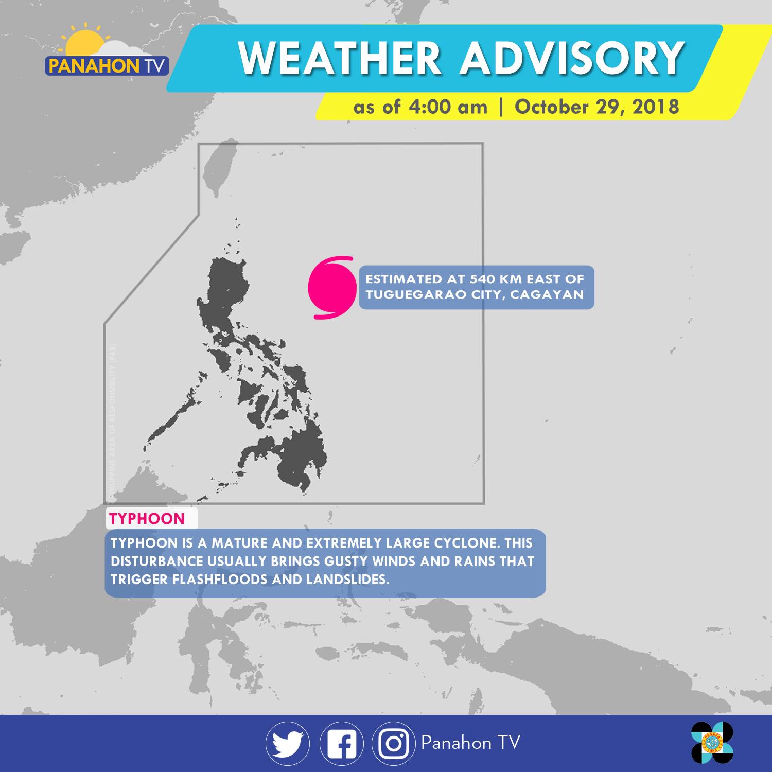
As of 5:00 a.m., Typhoon Rosita was spotted 540 kilometers (km) east of Tuguegarao City, Cagayan. It has maximum sustained winds of 170 kilometers per hour (kph) and gustiness of up to 210 kph. The Typhoon has slightly weakened as it moves westward at 15 kph. It will bring stormy weather or heavy rains with strong winds in Cagayan, Isabela, Quirino, Aurora and Polilio Island. Meanwhile, rains with gusty winds are expected in the Cordillera Administrative Region, Ilocos Region, the rest of Cagayan Valley and Central Luzon, and the provinces of Rizal and Camarines Norte. Due to its trough or extension, Metro Manila, the rest of CALABARZON and of Bicol Region will have cloudy skies with scattered rain showers and thunderstorms. Meanwhile, partly cloudy to cloudy skies with isolated rain showers will prevail in the rest of the country.
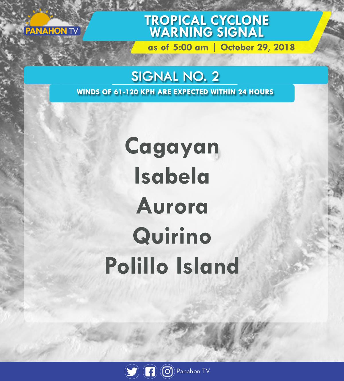
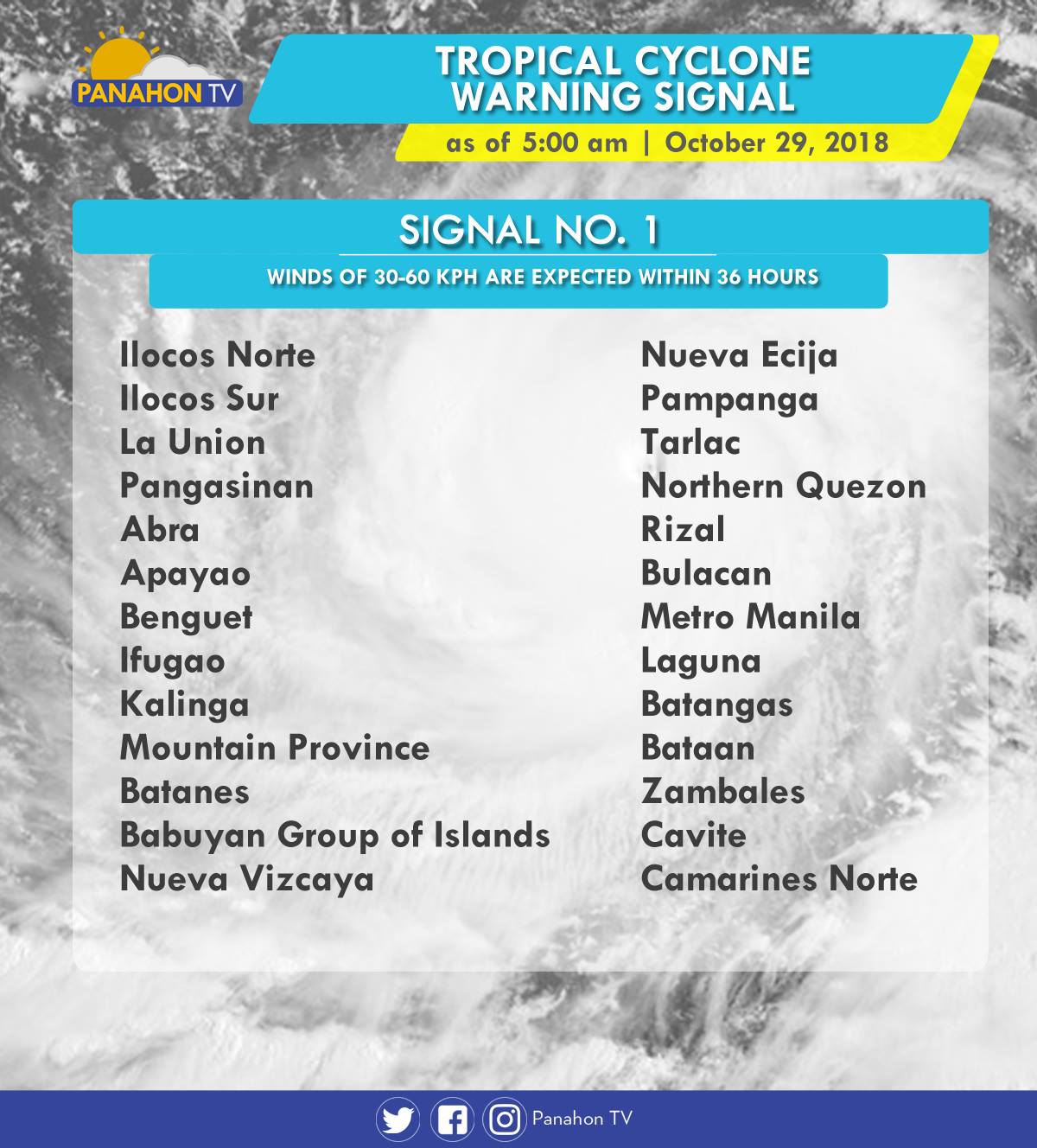
As Typhoon Rosita approaches the eastern section of Northern Luzon, Tropical Cyclone Warning Signals (TCWS) are raised by PAGASA in the following areas in preparation for incoming Typhoon.
In an Interview with PAGASA Weather Forecaster Ezra Bulquerin, he mentioned that the Typhoon may slightly weaken as it traverses the landmass of Northern Luzon. Although some parts of the country are already experiencing stormy weather, the Typhoon is expected to hit the landmass of Isabela-Cagayan later this evening. He also added that the Northeast Monsoon will not strengthen the Typhoon, but will only steer it toward Northern Luzon.
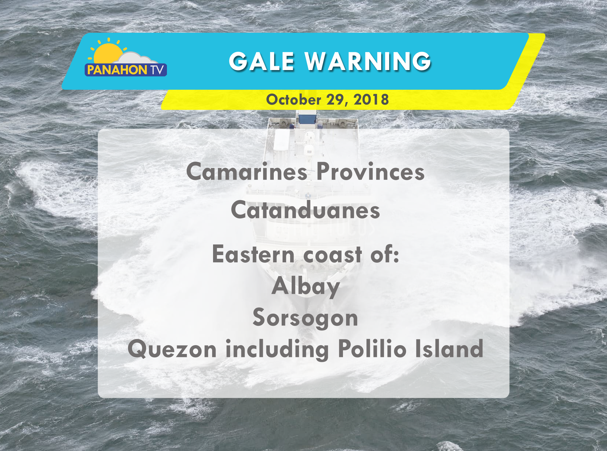
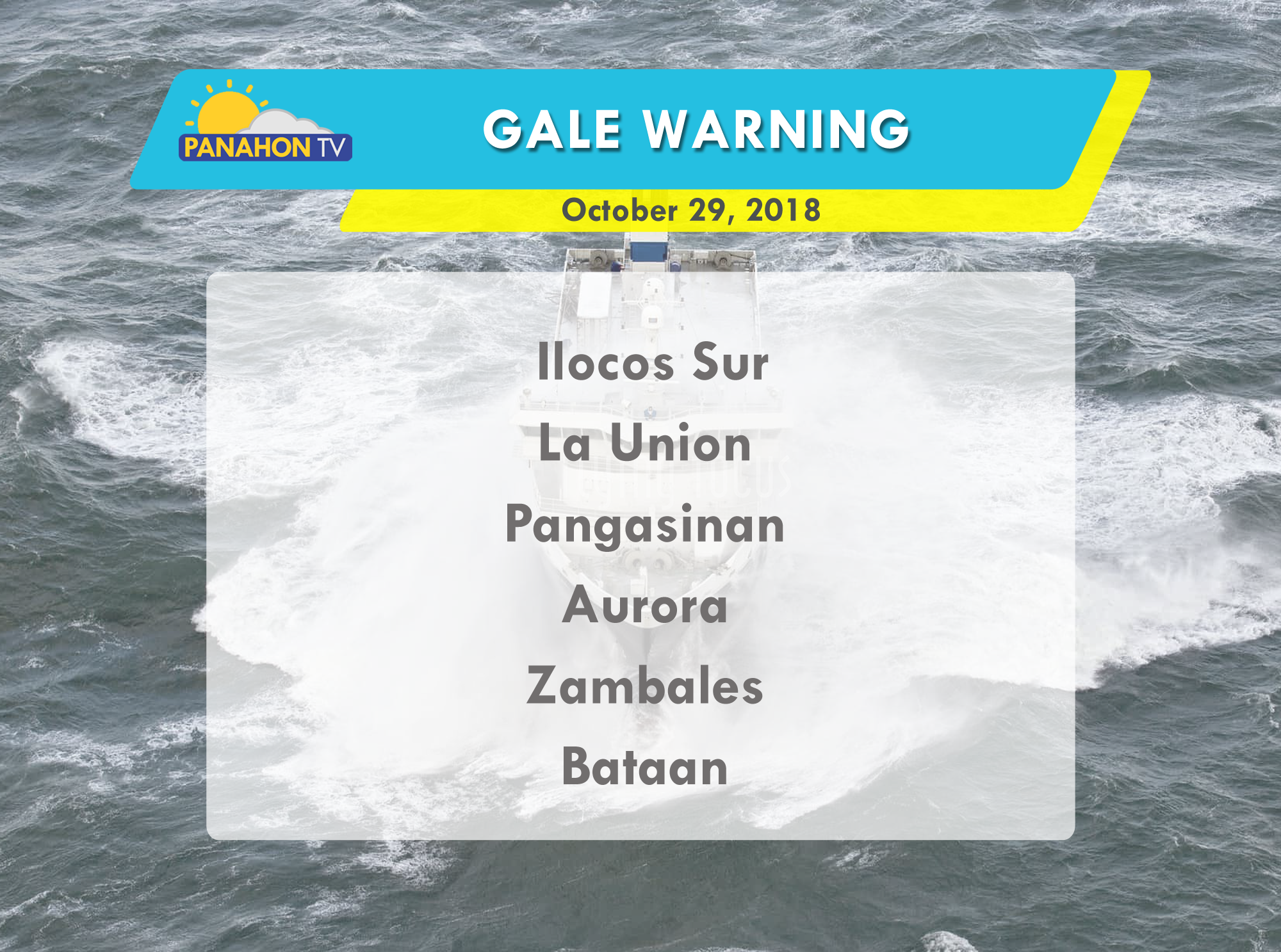
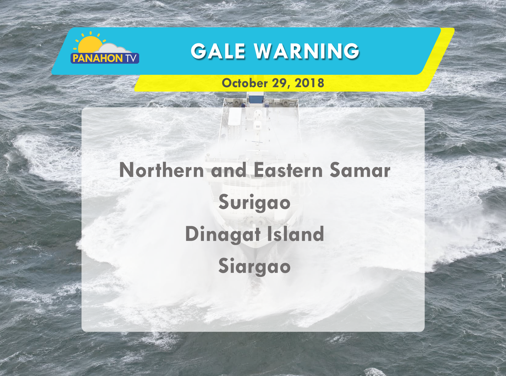
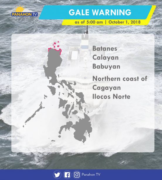
Due to strong waves brought by the Typhoon, gale warning is issued in the following areas:

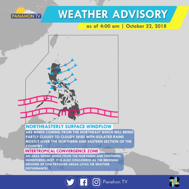
The Northeasterly Surface Windflow continues to affect Luzon, bringing cloudy skies with scattered rain showers and thunderstorms in Quezon, Bicol Region and the rest of MIMAROPA. Meanwhile, cloudy skies with scattered rain showers and thunderstorms are expected in Mindanao and Palawan caused by the Intertropical Convergence Zone (ITCZ), or the imaginary where winds from Northern and Southern Hemisphere meet. Metro Manila and the rest of the country will have partly cloudy to cloudy skies with isolated rain showers.
According to PAGASA Weather Forecaster Meno Mendoza, a Tropical Storm with international name “Yutu” was spotted outside the Philippine Area of Responsibility (PAR) 3,375 km east of Mindanao. It is expected to move northward, and will not enter PAR. He also added that cold air brought by the Amihan or Northeast Monsoon will be felt in the last week of October.
No gale warning is issued today.
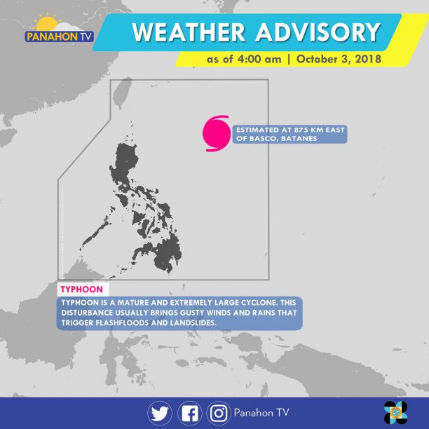
At 3:00 a.m. today, Typhoon #QueeniePH was spotted 875 kilometers east of Basco, Batanes. Moving northwest at 20 kilometers per hour (kph), it has maximum sustained winds of 200 kph and gustiness of up to 245 kph. Due to the trough of Typhoon Queenie, cloudy skies with scattered rain showers and thunderstorms are expected in Central Luzon, Eastern Visayas, Northern Mindanao, and Caraga. Meanwhile, partly cloudy to cloudy skies with isolated rain showers will prevail in Metro Manila and the rest of the country.
According to PAGASA Weather Forecaster Chris Perez, although Typhoon Queenie is not expected to make its landfall, it will still bring rains in due to its trough. If its speed remains constant, it is expected to exit the Philippine Area of Responsibility by Friday.
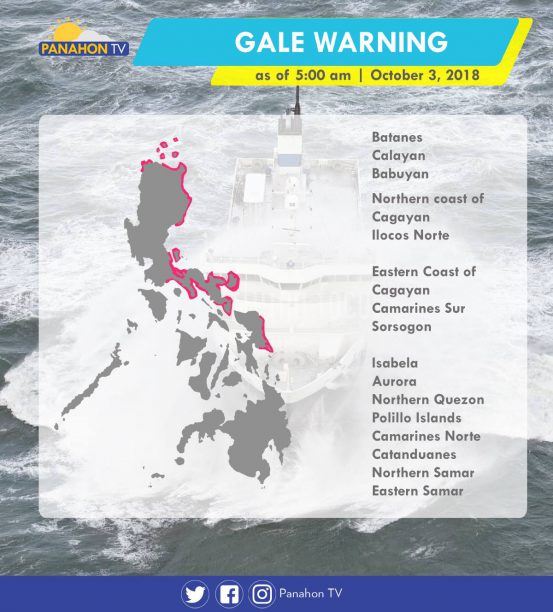
Meanwhile, gale warning is still issued in the following areas.
As of 3:00 a.m., Typhoon Kong-Rey was last spotted 1,565 kilometers (km) east of Southern Luzon. It has maximum sustained winds of up to 130 kilometers per hour (kph) and gustiness of up to 160 kph, moving west-northwest at 15 kph. Due to the trough of the Typhoon, cloudy skies with scattered rain showers and thunderstorms are expected in Bicol Region and Eastern Visayas. Meanwhile, partly cloudy to cloudy skies with isolated rain showers will prevail in Metro Manila and the rest of the country.
According to PAGASA Weather Forecaster Ariel Rojas, the Typhoon Kong-Rey will enter the Philippine Area of Responsibility (PAR), making it the 17th Tropical Cyclone to enter PAR this year.
Gale warning is issued in the following areas:
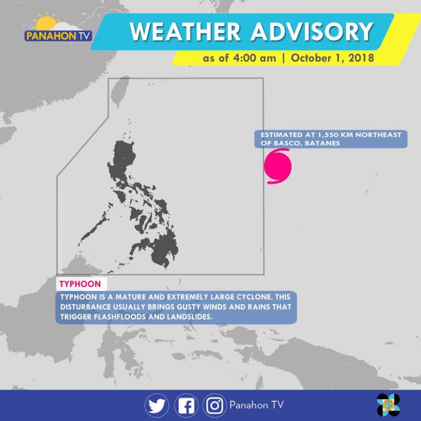
As of 3:00 a.m., Tropical Storm Kong-Rey was last spotted 1,550 km (kilometers) east of Visayas. It has maximum sustained winds of up to 80 kilometers per hour (kph) and gustiness of up to 95 kph. It is moving west-northwest at 25 kph.
Due to the trough of Tropical Storm Kong-rey, cloudy skies with scattered rain showers and thunderstorms are expected in Eastern Visayas, while partly cloudy to cloudy skies with isolated rain showers will prevail in Metro Manila and the rest of the country.
In an interview with PAGASA Weather Forecaster Meno Mendoza, the Tropical Storm is expected to enter the Philippine Area of Responsibility (PAR) by Tuesday. He also added that if the Tropical Cyclone maintains its course, it will have same track as Typhoon Paeng’s.
Gale warning was issued in the northern and eastern seaboards of Northern Luzon and the eastern seaboard of Central Luzon.
Northern Luzon should brace for rains induced by Typhoon Paeng.
At 3:00 a.m., the eye of the typhoon was spotted 740 kilometers east of Basco, Batanes. It has slightly intensified with maximum sustained winds of 200 kilometers per hour (kph), gustiness of up to 240 kph, moving west-northwest at 10 kph. According to PAGASA Weather Forecaster Ariel Rojas, light to moderate rains will prevail in Northern Luzon starting Friday. Tropical Cyclone Warning Signals may also be hoisted. The typhoon is expected to exit the Philippine Area of Responsibility on Saturday.
Today, the trough or extension of the typhoon will bring cloudy skies with scattered rain showers in Western Visayas, Zamboanga Peninsula, ARMM and Soccsksargen. Elsewhere, partly cloudy to cloudy skies prevail, but isolated rain showers are still possible due to localized thunderstorms.
PAGASA raised a gale warning off the northern seaboards of Northern Luzon and eastern seaboards of Luzon. Fisherfolk and those with small seacraft are advised not to venture out, while larger vessels are advised to take precautionary measures against rough to very rough sea conditions.
As of 3:00 a.m., Severe Tropical Storm Trami was last spotted 1,580 kilometers east of Central Luzon (outside PAR). With maximum sustained winds of 100 kph (kilometers per hour) and gustiness of up to 120 kph, it moves west-northwest at 20 kph. Later this afternoon, it is expected to enter the Philippine Area of Responsibility (PAR).
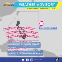
Meanwhile, the Intertropical Convergence Zone (ITCZ) still affects Southern Luzon, Visayas and Mindanao. It brings cloudy skies with scattered rain showers and thunderstorms in Visayas, Mindanao and Palawan. Meanwhile, partly cloudy to cloudy skies with isolated rain showers are expected in Metro Manila and the rest of Luzon.
According to PAGASA Weather Forecaster Meno Mendoza, the Severe Tropical Storm is expected to enter PAR later this afternoon, making it the country’s 16thTropical Cyclone of the year. Once this happens, it will be named Typhoon Paeng. If it remains its track, it will affect the northern and eastern sections of Northern Luzon.
No gale warning was issued today.
A new weather disturbance was spotted outside the Philippine Area of Responsibility (PAR).
According to PAGASA Weather Forecaster Meno Mendoza, though the Low Pressure Area (LPA), located east of Visayas, has a slim chance of developing into a Tropical Cyclone, it will still induce rains.
Due to the trough or extension of the LPA, Bicol Region and Eastern Visayas will have cloudy skies with scattered rain showers and thunderstorms that can trigger flash floods or landslides. With the presence of the Northeast Monsoon, cloudy skies with scattered rains will be experienced in Cagayan Valley Region, Cordillera Administrative Region and the provinces of Aurora and Quezon. In the rest of Luzon, including Metro Manila, generally fair weather will prevail except for chances of isolated rains. The remaining parts of the country can also enjoy fair weather conditions but with chances of localized thunderstorms.
Gale warning is still in effect in the northern seaboards of Northern Luzon, the western seaboards of Central and Southern Luzon, and the eastern seaboard of Central and Southern Luzon. These include coasts of Batanes, Calayan, Babuyan, Cagayan, Ilocos Norte, Ilocos Sur, La Union, Pangasinan and Isabela, Zambales, Bataan, Palawan, Aurora, Camarines Provinces, Catanduanes, and the eastern coast of Quezon including Polillo Island. Fishing boats and other small seacraft are prohibited from venturing while larger sea vessels are alerted against rough to very rough seas.
The Low Pressure Area (LPA) east of Mindanao has dissipated, leaving two weather systems dominant.
Today, Cagayan Valley, Cordillera, Aurora and Quezon will experience cloudy skies with scattered rains. In Visayas, Bicol Region, Caraga, Northern Mindanao and Zamboanga Peninsula, cloudy skies with scattered rains showers and thunderstorms will prevail, making floods or landslides possible. In Metro Manila, Ilocos Region and Central Luzon, partly cloudy to cloudy skies with isolated rains will be experienced. In rest of the country, partly cloudy to cloudy skies will be experienced only with isolated rain showers.
With the surge of Amihan, gale warning is hoisted off the seaboards of Northern Luzon, down to the western and eastern seaboards of Central and Southern Luzon. These include Batanes, Calayan, Babuyan, Cagayan, Ilocos Norte, Ilocos Sur, La Union, Pangasinan, Isabela, Zambales, Bataan, Palawan, Aurora, Camarines Provinces, Catanduanes and the eastern coast of Quezon including Polillo Island. Due to rough to very rough sea condition, fishing boats and small sea craft are prohibited from venturing, while larger vessels are alerted against big waves.